FAA INFORMATION EFFECTIVE 09 JULY 2026
Location
| FAA Identifier: | C80 |
| Lat/Long: | 36-09-43.6000N 120-17-41.4000W
36-09.726667N 120-17.690000W
36.1621111,-120.2948333
(estimated) |
| Elevation: | 624.8 ft. / 190 m (estimated) |
| Variation: | 15E (1995) |
| From city: | 3 miles E of COALINGA, CA |
| Time zone: | UTC -7 (UTC -8 during Standard Time) |
| Zip code: | 93210 |
Airport Operations
| Airport use: | Open to the public |
| Activation date: | 10/1996 |
| Control tower: | no |
| ARTCC: | OAKLAND CENTER |
| FSS: | RANCHO MURIETA FLIGHT SERVICE STATION |
| NOTAMs facility: | RIU (NOTAM-D service available) |
| Attendance: | IREG |
| Wind indicator: | lighted |
| Segmented circle: | yes |
| Lights: | REIL RWYS 12 & 30; MIRL RWY 12/30; PERIMETER LGTS H1 ON DUSK-0000; AFTER 0000 ACTVT - CTAF. PAPI RWYS 12 & 30 OPR CONSLY. |
| Beacon: | white-green (lighted land airport)
DUSK-DAWN. |
Airport Communications
| CTAF/UNICOM: | 122.7 |
| WX AWOS-3: | 119.275 (559-935-5960) |
| WX AWOS-3 at NLC (19 nm NE): | 121.575 (559-998-2336) |
- APCH/DEP CTLSVC PRVDD BY OAKLAND ARTCC (ZOA) ON 128.7/307.0 (PRIEST RCAG).
Nearby radio navigation aids
| VOR radial/distance | | VOR name | | Freq | | Var |
|---|
| PRBr013/33.5 | | PASO ROBLES VORTAC | | 114.30 | | 16E |
| AVEr318/34.5 | | AVENAL VOR/DME | | 117.10 | | 16E |
| NDB name | | Hdg/Dist | | Freq | | Var | | ID |
|---|
| SALYER FARMS | | 263/37.5 | | 205 | | 16E | | COR | -.-. --- .-. |
Airport Services
Runway Information
Runway 12/30
| Dimensions: | 5000 x 100 ft. / 1524 x 30 m |
| Surface: | asphalt, in fair condition |
| Weight bearing capacity: | |
| Runway edge lights: | medium intensity |
| RUNWAY 12 | | RUNWAY 30 |
| Latitude: | 36-10.062167N | | 36-09.524582N |
| Longitude: | 120-18.014008W | | 120-17.243900W |
| Elevation: | 624.8 ft. | | 601.8 ft. |
| Traffic pattern: | left | | right |
| Runway heading: | 116 magnetic, 131 true | | 296 magnetic, 311 true |
| Markings: | nonprecision, in fair condition | | nonprecision, in fair condition |
| Visual slope indicator: | 2-light PAPI on left (3.00 degrees glide path) | | 2-light PAPI on left (3.00 degrees glide path)
RWY 30 VGSI OTS. |
| Runway end identifier lights: | yes | | yes |
| Touchdown point: | yes, no lights | | yes, no lights |
Runway 1/19
| Dimensions: | 2471 x 60 ft. / 753 x 18 m |
| Surface: | asphalt/gravel/L
RWY SFC FAILED WITH POTHOLES AND BRUSH. |
| Weight bearing capacity: | |
| Operational restrictions: | RWY CLSD. |
| RUNWAY 1 | | RUNWAY 19 |
| Latitude: | 36-09.394800N | | 36-09.793513N |
| Longitude: | 120-17.862395W | | 120-17.760432W |
| Elevation: | 606.9 ft. | | 608.0 ft. |
| Traffic pattern: | left | | right |
| Runway heading: | 357 magnetic, 012 true | | 177 magnetic, 192 true |
| Markings: | basic, in poor condition | | basic, in poor condition |
| Touchdown point: | yes, no lights | | yes, no lights |
Helipad H1
| Dimensions: | 50 x 50 ft. / 15 x 15 m |
| Surface: | asphalt, in good condition |
| Runway edge lights: | PERI |
| Latitude: | 36-09.733667N | | |
| Longitude: | 120-17.686333W | | |
| Elevation: | 606.0 ft. | | |
| Traffic pattern: | left | | left |
| Markings: | basic, in good condition | | |
Airport Ownership and Management from official FAA records
| Ownership: | Publicly-owned |
| Owner: | CITY OF COALINGA
CITY HALL 155 W DURIAN
COALINGA, CA 93210
Phone 559-935-1533 |
| Manager: | MERCEDES GARCIA
THE CITY OF COALINGA, 155 W DURIAN
COALINGA, CA 93210-1911
Phone 559-246-6243
MGARCIA@COALINGA.COM |
Additional Remarks
| - | FOR CD CTC OAKLAND ARTCC AT 510-745-3380. |
| - | AWOS OTS. |
Instrument Procedures
NOTE: All procedures below are presented as PDF files. If you need a reader for these files, you should download the free Adobe Reader.NOT FOR NAVIGATION. Please procure official charts for flight.
FAA instrument procedures published for use from 09 July 2026 at 0901Z to 06 August 2026 at 0900Z.
IAPs - Instrument Approach Procedures |
|---|
| RNAV (GPS) RWY 30 | |
download (216KB) |
| NOTE: Special Alternate Minimums apply | |
download (137KB) |
|
|---|
| AVENAL ONE (OBSTACLE) | |
download (270KB) |
| NOTE: Special Take-Off Minimums/Departure Procedures apply | |
download (352KB) |
Other nearby airports with instrument procedures:
KNLC - Lemoore Naval Air Station (Reeves Field) (19 nm NE)
KPRB - Paso Robles Municipal Airport (34 nm SW)
KHJO - Hanford Municipal Airport (34 nm E)
KKIC - Mesa Del Rey Airport (40 nm W)
KFCH - Fresno Chandler Executive Airport (41 nm NE)
|
|

Road maps at:
MapQuest
Bing
Google
| Aerial photo |
|---|
WARNING: Photo may not be current or correct

Do you have a better or more recent aerial photo of New Coalinga Municipal Airport that you would like to share? If so, please send us your photo.
|
| Sectional chart |
|---|
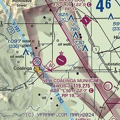
|
| Airport distance calculator |
|---|
|
|
| Sunrise and sunset |
|---|
|
Times for 30-Jul-2026
| | Local
(UTC-7) | | Zulu
(UTC) |
|---|
| Morning civil twilight | | 05:39 | | 12:39 |
| Sunrise | | 06:08 | | 13:08 |
| Sunset | | 20:08 | | 03:08 |
| Evening civil twilight | | 20:36 | | 03:36 |
|
| Current date and time |
|---|
| Zulu (UTC) | 30-Jul-2026 22:11:59 |
|---|
| Local (UTC-7) | 30-Jul-2026 15:11:59 |
|---|
|
| METAR |
|---|
KNLC
19nm NE | 302156Z 34006KT 10SM CLR 39/07 A2986 RMK AO2 SLP108 RH/14 T03890067
|
KPRB
34nm SW | 302153Z AUTO 30009KT 10SM CLR 38/02 A2994 RMK AO2 SLP128 T03830017
|
KHJO
34nm E | 302153Z AUTO VRB03KT 10SM SCT110 38/07 A2986 RMK AO2 SLP111 T03780072
|
|
| TAF |
|---|
KNLC
19nm NE | 301400Z 3015/3115 30007KT 9999 SKC QNH2987INS FM301800 34009KT 9999 SKC QNH2981INS TX39/3023Z TN17/3113Z FS30067
|
|
| NOTAMs |
|---|
NOTAMs are issued by the DoD/FAA and will open in a separate window not controlled by AirNav.
|
|

