FAA INFORMATION EFFECTIVE 09 JULY 2026
Location
| FAA Identifier: | C83 |
| Lat/Long: | 37-49-42.4000N 121-37-33.0000W
37-49.706667N 121-37.550000W
37.8284444,-121.6258333
(estimated) |
| Elevation: | 78.5 ft. / 23.9 m (surveyed) |
| Variation: | 15E (1995) |
| From city: | 2 miles S of BYRON, CA |
| Time zone: | UTC -7 (UTC -8 during Standard Time) |
| Zip code: | 94514 |
Airport Operations
| Airport use: | Open to the public |
| Activation date: | 11/1994 |
| Control tower: | no |
| ARTCC: | OAKLAND CENTER |
| FSS: | OAKLAND FLIGHT SERVICE STATION |
| NOTAMs facility: | OAK (NOTAM-D service available) |
| Attendance: | 0700-1400 |
| Segmented circle: | yes |
| Lights: | PCL AVBL SS-SR. ACTVT REIL RWY 30; MIRL RWY 12/30 & 05/23 - CTAF. |
| Beacon: | white-green (lighted land airport)
Operates sunset to sunrise. |
Airport Communications
| CTAF/UNICOM: | 123.05 |
| WX AWOS-3: | 123.775 (925-634-0906) |
| NORCAL APPROACH: | 123.85 |
| NORCAL DEPARTURE: | 123.85 |
| WX AWOS-3 at TCY (12 nm SE): | 118.375 (209-831-4335) |
| WX ASOS at LVK (12 nm SW): | PHONE 925-606-5412 |
| WX ASOS at SCK (19 nm E): | PHONE 209-625-0001 |
Nearby radio navigation aids
| VOR radial/distance | | VOR name | | Freq | | Var |
|---|
| CCRr106/23.7 | | CONCORD VOR/DME | | 117.00 | | 17E |
| OAKr061/29.0 | | OAKLAND VOR/DME | | 116.80 | | 17E |
| SJCr013/31.2 | | SAN JOSE VOR/DME | | 114.10 | | 16E |
| LINr226/32.9 | | LINDEN VOR/DME | | 114.80 | | 17E |
| MODr274/33.9 | | MODESTO VOR/DME | | 114.60 | | 17E |
| SACr168/37.1 | | SACRAMENTO VORTAC | | 115.20 | | 17E |
| SFOr054/37.7 | | SAN FRANCISCO VOR/DME | | 115.80 | | 17E |
Airport Services
| Fuel available: | 100LL
100LL:FUEL AVBL 24 HRS BY CREDIT CARD. |
| Parking: | tiedowns |
Runway Information
Runway 12/30
| Dimensions: | 4500 x 100 ft. / 1372 x 30 m |
| Surface: | asphalt, in good condition |
| Weight bearing capacity: | |
| Runway edge lights: | medium intensity |
| RUNWAY 12 | | RUNWAY 30 |
| Latitude: | 37-50.141590N | | 37-49.614882N |
| Longitude: | 121-37.892008W | | 121-37.234142W |
| Elevation: | 64.1 ft. | | 48.4 ft. |
| Traffic pattern: | left | | right |
| Runway heading: | 120 magnetic, 135 true | | 300 magnetic, 315 true |
| Markings: | nonprecision, in good condition | | nonprecision, in good condition |
| Visual slope indicator: | | | 2-light PAPI on left (3.50 degrees glide path) |
| Runway end identifier lights: | | | yes |
| Touchdown point: | yes, no lights | | yes, no lights |
| Obstructions: | 61 ft. pole, 1591 ft. from runway, 261 ft. right of centerline, 22:1 slope to clear | | 65 ft. hill, 3218 ft. from runway, 729 ft. left of centerline, 46:1 slope to clear |
Runway 5/23
| Dimensions: | 3000 x 75 ft. / 914 x 23 m |
| Surface: | asphalt, in good condition |
| Weight bearing capacity: | |
| Runway edge lights: | medium intensity |
| RUNWAY 5 | | RUNWAY 23 |
| Latitude: | 37-49.339182N | | 37-49.562193N |
| Longitude: | 121-37.806992W | | 121-37.250970W |
| Elevation: | 78.5 ft. | | 48.6 ft. |
| Traffic pattern: | right | | left |
| Runway heading: | 048 magnetic, 063 true | | 228 magnetic, 243 true |
| Markings: | basic, in good condition | | basic, in good condition |
| Visual slope indicator: | | | 2-light PAPI on left (3.50 degrees glide path) |
| Touchdown point: | yes, no lights | | yes, no lights |
Airport Ownership and Management from official FAA records
| Ownership: | Publicly-owned |
| Owner: | CONTRA COSTA COUNTY
181 JOHN GLENN DR, SUITE 100
CONCORD, CA 94520
Phone 925-608-8000 |
| Manager: | GREG BAER
181 JOHN GLENN DR, SUITE 100
CONCORD, CA 94250
Phone 925-608-8000
DIRECTOR OF ARPTS CONTRA COSTA COUNTY. |
Additional Remarks
| A52-05 | WIND TURBINES |
| - | ULTRALIGHT & SAILPLANE ACTIVITY ON & INVOF ARPT. |
| - | PRCHT ACT AT NW END OF ARPT. |
| - | RISING TERRAIN WITH NUMEROUS WINDMILLS ON RIDGES WEST OF ARPT. |
| - | HANGAR APRON & TIEDOWN APRON 12500 LBS MAX. |
| - | RY 30 CALM WIND RY. |
| - | 200' TOWER 5600 FEET FROM RUNWAY 05. |
| - | 100' TOWER 5100 FEET FROM RUNWAY 23. |
| - | POWER PLANT 2.7 MILES SE OF AIRPORT PRODUCING THERMAL PLUMES; AVOID OVERLFIGHT BELOW 1,500 FT AGL. |
| - | FOR CD CTC NORCAL APCH AT 916-361-0516. |
| - | FREQ UAS DRONE ACT 7.8 NM DIAM ARND FLD UP TO 8000 FT. |
Instrument Procedures
NOTE: All procedures below are presented as PDF files. If you need a reader for these files, you should download the free Adobe Reader.NOT FOR NAVIGATION. Please procure official charts for flight.
FAA instrument procedures published for use from 09 July 2026 at 0901Z to 06 August 2026 at 0900Z.
IAPs - Instrument Approach Procedures |
|---|
| RNAV (GPS) RWY 30 | |
download (240KB) |
| NOTE: Special Alternate Minimums apply | |
download |
| NOTE: Special Take-Off Minimums/Departure Procedures apply | |
download (587KB) |
Other nearby airports with instrument procedures:
KTCY - Tracy Municipal Airport (12 nm SE)
KLVK - Livermore Municipal Airport (12 nm SW)
KSCK - Stockton Metro Airport (19 nm E)
O88 - Rio Vista Municipal Airport (22 nm N)
KCCR - Buchanan Field Airport (23 nm NW)
|
|

Road maps at:
MapQuest
Bing
Google
| Aerial photo |
|---|
WARNING: Photo may not be current or correct
 Photo by David Newcomer
Photo taken 23-Oct-2014
from 3,000 AGL looking northeast.
Photo by David Newcomer
Photo taken 23-Oct-2014
from 3,000 AGL looking northeast.
Do you have a better or more recent aerial photo of Byron Airport that you would like to share? If so, please send us your photo.
|
| Sectional chart |
|---|
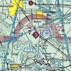
|
CAUTION: Diagram may not be current

| Airport distance calculator |
|---|
|
|
| Sunrise and sunset |
|---|
|
Times for 28-Jul-2026
| | Local
(UTC-7) | | Zulu
(UTC) |
|---|
| Morning civil twilight | | 05:38 | | 12:38 |
| Sunrise | | 06:08 | | 13:08 |
| Sunset | | 20:18 | | 03:18 |
| Evening civil twilight | | 20:48 | | 03:48 |
|
| Current date and time |
|---|
| Zulu (UTC) | 29-Jul-2026 04:02:13 |
|---|
| Local (UTC-7) | 28-Jul-2026 21:02:13 |
|---|
|
| METAR |
|---|
| KC83 | 290355Z AUTO 23019G27KT 10SM CLR 24/11 A2980 RMK AO2
|
KLVK
12nm SW | 290353Z 30007KT 10SM CLR 21/13 A2987 RMK AO2 SLP109 T02060133
|
KTCY
12nm SE | 290355Z AUTO 25014G20KT 10SM CLR 28/07 A2980 RMK A01
|
KSCK
20nm E | 290355Z AUTO 27008KT 10SM CLR 26/12 A2981 RMK AO2 SLP093 T02560122 $
|
|
| TAF |
|---|
KLVK
12nm SW | 281720Z 2818/2918 29011KT P6SM SKC
|
KSCK
20nm E | 281720Z 2818/2918 VRB04KT P6SM SKC FM290100 28011KT P6SM SKC FM290500 30006KT P6SM SKC FM291200 31007KT P6SM SKC
|
|
| NOTAMs |
|---|
NOTAMs are issued by the DoD/FAA and will open in a separate window not controlled by AirNav.
|
|


