FAA INFORMATION EFFECTIVE 04 SEPTEMBER 2025
Location
| FAA Identifier: | CTB |
| Lat/Long: | 48-36-30.0771N 112-22-34.1428W
48-36.501285N 112-22.569047W
48.6083547,-112.3761508
(estimated) |
| Elevation: | 3857.8 ft. / 1175.9 m (surveyed) |
| Variation: | 13E (2015) |
| From city: | 3 miles SW of CUT BANK, MT |
| Time zone: | UTC -6 (UTC -7 during Standard Time) |
| Zip code: | 59427 |
Airport Operations
| Airport use: | Open to the public |
| Activation date: | 09/1941 |
| Control tower: | no |
| ARTCC: | SALT LAKE CITY CENTER |
| FSS: | GREAT FALLS FLIGHT SERVICE STATION |
| NOTAMs facility: | CTB (NOTAM-D service available) |
| Attendance: | 0830-1730 |
| Wind indicator: | lighted |
| Segmented circle: | yes |
| Lights: | ACTVT MIRL RWY 05/23 & 14/32; REIL RWY 32 - CTAF. PAPI RWY 23; VASI RWY 32 OPR CONSLY. |
| Beacon: | white-green (lighted land airport)
Operates sunset to sunrise. |
| International operations: | international airport of entry |
Airport Communications
| CTAF/UNICOM: | 123.0 |
| WX ASOS: | 119.025 (406-873-2939) |
- APCH/DEP CTL SVC PRVDD BY SALT LAKE CITY ARTCC ( ZLC) ON FREQS 133.4/285.4 (GREAT FALLS RCAG).
Nearby radio navigation aids
| VOR radial/distance | | VOR name | | Freq | | Var |
|---|
| CTBr316/2.9 | | CUT BANK VOR/DME | | 113.35 | | 17E |
Airport Services
| Fuel available: | 100LL JET-A JET-A+ |
| Parking: | hangars and tiedowns |
| Airframe service: | NONE |
| Powerplant service: | NONE |
| Bottled oxygen: | NONE |
| Bulk oxygen: | NONE |
Runway Information
Runway 5/23
| Dimensions: | 5300 x 75 ft. / 1615 x 23 m |
| Surface: | asphalt, in excellent condition |
| Weight bearing capacity: | | PCN 10 /F/D/Y/U | | Single wheel: | 27.5 | | Double wheel: | 37.5 |
|
| Runway edge lights: | medium intensity |
| RUNWAY 5 | | RUNWAY 23 |
| Latitude: | 48-36.389367N | | 48-36.772483N |
| Longitude: | 112-23.113432W | | 112-21.933098W |
| Elevation: | 3853.8 ft. | | 3840.1 ft. |
| Traffic pattern: | left | | left |
| Runway heading: | 051 magnetic, 064 true | | 231 magnetic, 244 true |
| Markings: | nonprecision, in good condition | | nonprecision, in good condition |
| Visual slope indicator: | | | 2-light PAPI on left (3.00 degrees glide path) |
| Touchdown point: | yes, no lights | | yes, no lights |
Runway 14/32
| Dimensions: | 5300 x 75 ft. / 1615 x 23 m |
| Surface: | asphalt, in excellent condition |
| Weight bearing capacity: | | PCN 10 /F/D/Y/U | | Single wheel: | 27.5 | | Double wheel: | 37.5 |
|
| Runway edge lights: | medium intensity |
| RUNWAY 14 | | RUNWAY 32 |
| Latitude: | 48-36.807007N | | 48-36.036280N |
| Longitude: | 112-22.921487W | | 112-22.308172W |
| Elevation: | 3857.8 ft. | | 3841.6 ft. |
| Traffic pattern: | left | | left |
| Runway heading: | 139 magnetic, 152 true | | 319 magnetic, 332 true |
| Markings: | nonprecision, in good condition | | nonprecision, in good condition |
| Visual slope indicator: | | | 4-box VASI on left (3.00 degrees glide path) |
| Runway end identifier lights: | | | yes |
| Touchdown point: | yes, no lights | | yes, no lights |
Airport Ownership and Management from official FAA records
| Ownership: | Publicly-owned |
| Owner: | CITY OF CUT BANK AND GLACIER COUNTY
P.O. BOX 130
CUT BANK, MT 59427
Phone 406-873-8683 |
| Manager: | TOM REDFIELD
P.O. BOX 130
CUT BANK, MT 59427
Phone 406-873-8683 |
Additional Remarks
| - | FOR FUEL AFT HRS CALL 406-873-8683 OR 406-849-4245 CELL. |
| - | 24 HOUR CUSTOMS AVBL ON CALL-OUT 406-335-9610 EXT. 314. |
| - | FOR CD IF UNA TO CTC ON FSS FREQ, CTC SALT LAKE ARTCC AT 801-320-2568. |
| - | COLD TEMPERATURE AIRPORT. ALTITUDE CORRECTION REQUIRED AT OR BELOW -28C. |
| - | (CONTACT TITLE) EMAIL: CBAA_MT@YAHOO.COM |
Instrument Procedures
NOTE: All procedures below are presented as PDF files. If you need a reader for these files, you should download the free Adobe Reader.NOT FOR NAVIGATION. Please procure official charts for flight.
FAA instrument procedures published for use from 04 September 2025 at 0901Z to 02 October 2025 at 0900z.
IAPs - Instrument Approach Procedures |
|---|
| RNAV (GPS) RWY 05 | |
download (218KB) |
| RNAV (GPS) RWY 14 | |
download (216KB) |
| RNAV (GPS) RWY 23 | |
download (218KB) |
| RNAV (GPS) RWY 32 | |
download (216KB) |
| VOR RWY 32 | |
download (185KB) |
| NOTE: Special Alternate Minimums apply | |
download (59KB) |
Departure Procedures |
|---|
| MRIAS THREE (RNAV) | |
download (166KB) |
| NOTE: Special Take-Off Minimums/Departure Procedures apply | |
download |
Other nearby airports with instrument procedures:
KSBX - Shelby Airport (20 nm E)
S01 - Conrad Airport (31 nm SE)
KCII - Choteau Airport (48 nm S)
KGPI - Glacier Park International Airport (77 nm W)
KGTF - Great Falls International Airport (79 nm SE)
|
|

Road maps at:
MapQuest
Bing
Google
| Aerial photo |
|---|
WARNING: Photo may not be current or correct

Do you have a better or more recent aerial photo of Cut Bank International Airport that you would like to share? If so, please send us your photo.
|
| Sectional chart |
|---|
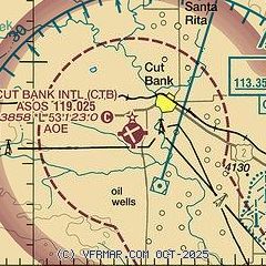
|
| Airport distance calculator |
|---|
|
|
| Sunrise and sunset |
|---|
|
Times for 08-Sep-2025
| | Local
(UTC-6) | | Zulu
(UTC) |
|---|
| Morning civil twilight | | 06:25 | | 12:25 |
| Sunrise | | 06:57 | | 12:57 |
| Sunset | | 19:57 | | 01:57 |
| Evening civil twilight | | 20:29 | | 02:29 |
|
| Current date and time |
|---|
| Zulu (UTC) | 09-Sep-2025 00:10:50 |
|---|
| Local (UTC-6) | 08-Sep-2025 18:10:50 |
|---|
|
| METAR |
|---|
| KCTB | 082356Z AUTO 28009KT 10SM CLR 26/03 A2998 RMK AO2 SLP125 T02610033 10261 20206 56008
|
|
| TAF |
|---|
| KCTB | 081720Z 0818/0918 30009G16KT P6SM SCT080 BKN120 TEMPO 0819/0823 VRB15G25KT 6SM -SHRA BKN080 FM090300 VRB06KT P6SM FEW200
|
|
| NOTAMs |
|---|
NOTAMs are issued by the DoD/FAA and will open in a separate window not controlled by AirNav.
|
|

