FAA INFORMATION EFFECTIVE 27 NOVEMBER 2025
Location
| FAA Identifier: | CTK |
| Lat/Long: | 40-34-08.7000N 090-04-29.4000W
40-34.145000N 090-04.490000W
40.5690833,-90.0748333
(estimated) |
| Elevation: | 683.9 ft. / 208.5 m (surveyed) |
| Variation: | 02W (2025) |
| From city: | 2 miles NW of CANTON, IL |
| Time zone: | UTC -6 (UTC -5 during Daylight Saving Time) |
| Zip code: | 61520 |
Airport Operations
| Airport use: | Open to the public |
| Control tower: | no |
| ARTCC: | KANSAS CITY CENTER |
| FSS: | KANKAKEE FLIGHT SERVICE STATION |
| NOTAMs facility: | IKK (NOTAM-D service available) |
| Attendance: | 0700-DUSK |
| Pattern altitude: | 1483.9 ft. MSL |
| Wind indicator: | lighted |
| Segmented circle: | yes |
| Lights: | ACTVT MIRL RYS 09/27 & 18/36 & REIL RY 36 & TWY LGTS - 7 CLICKS ON CTAF. |
Airport Communications
| CTAF/UNICOM: | 122.8 |
| SAINT LOUIS APPROACH: | 125.8 |
| SAINT LOUIS DEPARTURE: | 125.8 |
| WX ASOS at PIA (18 nm E): | PHONE 309-322-3740 |
Nearby radio navigation aids
| VOR radial/distance | | VOR name | | Freq | | Var |
|---|
| PIAr239/14.5 | | PEORIA VORTAC | | 115.20 | | 04E |
| BRLr098/39.8 | | BURLINGTON VOR/DME | | 115.55 | | 05E |
| NDB name | | Hdg/Dist | | Freq | | Var | | ID |
|---|
| MACOMB | | 081/22.4 | | 251 | | 01E | | JZY | .--- --.. -.-- |
Airport Services
| Fuel available: | 100LL
100LL:SELF-SERV FUELING |
| Parking: | tiedowns |
| Airframe service: | MAJOR |
| Powerplant service: | MAJOR |
| Bottled oxygen: | NONE |
| Bulk oxygen: | NONE |
Runway Information
Runway 18/36
| Dimensions: | 3899 x 75 ft. / 1188 x 23 m |
| Surface: | asphalt, in good condition |
| Weight bearing capacity: | |
| Runway edge lights: | medium intensity |
| RUNWAY 18 | | RUNWAY 36 |
| Latitude: | 40-34.384482N | | 40-33.742578N |
| Longitude: | 090-04.432303W | | 090-04.449693W |
| Elevation: | 681.9 ft. | | 670.3 ft. |
| Traffic pattern: | left | | left |
| Runway heading: | 183 magnetic, 181 true | | 003 magnetic, 001 true |
| Markings: | nonprecision, in fair condition | | nonprecision, in fair condition |
| Runway end identifier lights: | no | | yes |
| Touchdown point: | yes, no lights | | yes, no lights |
Runway 9/27
| Dimensions: | 3294 x 60 ft. / 1004 x 18 m |
| Surface: | asphalt, in good condition |
| Weight bearing capacity: | |
| Runway edge lights: | medium intensity |
| RUNWAY 9 | | RUNWAY 27 |
| Latitude: | 40-34.238992N | | 40-34.242897N |
| Longitude: | 090-04.904380W | | 090-04.192912W |
| Elevation: | 683.8 ft. | | 681.8 ft. |
| Traffic pattern: | left | | left |
| Runway heading: | 091 magnetic, 089 true | | 271 magnetic, 269 true |
| Markings: | basic, in fair condition | | basic, in fair condition |
| Runway end identifier lights: | no | | no |
| Touchdown point: | yes, no lights | | yes, no lights |
| Obstructions: | none | | 53 ft. trees, 953 ft. from runway, 92 ft. left of centerline, 14:1 slope to clear |
Airport Ownership and Management from official FAA records
| Ownership: | Publicly-owned |
| Owner: | CANTON PARK DISTRICT
250 S AVE D
CANTON, IL 61520
Phone 309-647-1345 |
| Manager: | BRENT WHEELER
250 S AVE D
CANTON, IL 61520
Phone 309-647-1345
EMAIL ADDRESS: CPD_JOHNSON@SBCGLOBAL.NET (ALL LOWER CASE) |
Additional Remarks
| - | AWOS (DIGIWX) DECOMISSIONED |
| - | FOR CD CTC ST LOUIS APCH AT 314-890-1017. |
| - | AIRPORT BEACON NOT INSTALLED |
Instrument Procedures
NOTE: All procedures below are presented as PDF files. If you need a reader for these files, you should download the free Adobe Reader.NOT FOR NAVIGATION. Please procure official charts for flight.
FAA instrument procedures published for use from 27 November 2025 at 0901Z to 25 December 2025 at 0900Z.
IAPs - Instrument Approach Procedures |
|---|
| RNAV (GPS) RWY 18 | |
download (219KB) |
| RNAV (GPS) RWY 36 | |
download (241KB) |
| VOR-A | |
download (185KB) |
| NOTE: Special Take-Off Minimums/Departure Procedures apply | |
download (489KB) |
Other nearby airports with instrument procedures:
KPIA - General Downing - Peoria International Airport (18 nm E)
C15 - Pekin Municipal Airport (19 nm E)
3MY - Mount Hawley Auxiliary Airport (25 nm NE)
KMQB - Macomb Municipal Airport (26 nm W)
KGBG - Harrel W Timmons Galesburg Regional Airport (27 nm NW)
|
|

Road maps at:
MapQuest
Bing
Google
| Aerial photo |
|---|
WARNING: Photo may not be current or correct
 Photo courtesy PZNAM
Photo taken 22-Jul-2007
Photo courtesy PZNAM
Photo taken 22-Jul-2007
Do you have a better or more recent aerial photo of Ingersoll Airport that you would like to share? If so, please send us your photo.
|
| Sectional chart |
|---|
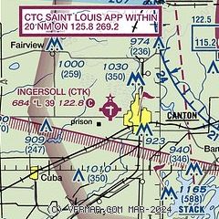
|
| Airport distance calculator |
|---|
|
|
| Sunrise and sunset |
|---|
|
Times for 12-Dec-2025
| | Local
(UTC-6) | | Zulu
(UTC) |
|---|
| Morning civil twilight | | 06:45 | | 12:45 |
| Sunrise | | 07:16 | | 13:16 |
| Sunset | | 16:33 | | 22:33 |
| Evening civil twilight | | 17:03 | | 23:03 |
|
| Current date and time |
|---|
| Zulu (UTC) | 12-Dec-2025 17:58:14 |
|---|
| Local (UTC-6) | 12-Dec-2025 11:58:14 |
|---|
|
| METAR |
|---|
KPIA
19nm E | 121754Z 32004KT 8SM FEW012 OVC020 M01/M04 A3014 RMK AO2 SLP214 T10111039 11011 21033 50000
|
KMQB
26nm W | 121735Z AUTO 32005KT 4SM BR SCT006 OVC015 M02/M03 A3018 RMK AO2 T10201032
|
KGBG
27nm NW | 121735Z AUTO 30004KT 5SM BR SCT008 OVC018 M03/M03 A3016 RMK AO2 T10311031
|
|
| TAF |
|---|
KPIA
19nm E | 121403Z 1214/1312 05005KT 5SM BR SCT008 OVC024 FM121800 31007KT P6SM SCT008 OVC012 FM130900 32009KT P6SM SCT020 BKN200
|
|
| NOTAMs |
|---|
NOTAMs are issued by the DoD/FAA and will open in a separate window not controlled by AirNav.
|
|

