FAA INFORMATION EFFECTIVE 25 DECEMBER 2025
Location
| FAA Identifier: | CVH |
| Lat/Long: | 36-53-36.0510N 121-24-36.9850W
36-53.600850N 121-24.616417W
36.8933475,-121.4102736
(estimated) |
| Elevation: | 230.6 ft. / 70.3 m (surveyed) |
| Variation: | 15E (1995) |
| From city: | 3 miles N of HOLLISTER, CA |
| Time zone: | UTC -8 (UTC -7 during Daylight Saving Time) |
| Zip code: | 95023 |
Airport Operations
| Airport use: | Open to the public |
| Activation date: | 04/1943 |
| Control tower: | no |
| ARTCC: | OAKLAND CENTER |
| FSS: | OAKLAND FLIGHT SERVICE STATION |
| NOTAMs facility: | OAK (NOTAM-D service available) |
| Attendance: | 0800-1700
AMGR AT ARPT MON-FRI 0800-1500. |
| Pattern altitude: | 1030.6 ft. MSL
TPA FOR HELICOPTERS 500 FT AGL. |
| Wind indicator: | lighted |
| Segmented circle: | yes |
| Lights: | ACTVT REIL RWY 24, 13, & 31; VASI RWY 24; PAPI RWY 13 & 31; MIRL RWY 06/24 & 13/31 - CTAF. |
| Beacon: | white-green (lighted land airport)
Operates sunset to sunrise. |
Airport Communications
| CTAF/UNICOM: | 123.0 |
| WX AWOS-3: | 120.425 (831-636-4394) |
| NORCAL APPROACH: | 124.525 |
| NORCAL DEPARTURE: | 124.525 |
| WX AWOS-3P at E16 (14 nm NW): | 118.350 (408-918-7724) |
| WX ASOS at SNS (17 nm SW): | PHONE 831-422-2830 |
| WX ASOS at WVI (18 nm W): | 132.275 (831-724-8794) |
Nearby radio navigation aids
| VOR radial/distance | | VOR name | | Freq | | Var |
|---|
| SNSr017/16.6 | | SALINAS VORTAC | | 117.30 | | 17E |
| PXNr273/32.2 | | PANOCHE VORTAC | | 112.60 | | 16E |
| SJCr122/38.6 | | SAN JOSE VOR/DME | | 114.10 | | 16E |
Airport Services
| Fuel available: | 100LL JET-A
100LL:FUEL AVBL 24 HRS CREDIT CARD LOCK SYSTEM. |
| Parking: | tiedowns |
| Airframe service: | MAJOR |
| Powerplant service: | MAJOR |
| Bottled oxygen: | NONE |
| Bulk oxygen: | NONE |
Runway Information
Runway 13/31
| Dimensions: | 6350 x 100 ft. / 1935 x 30 m |
| Surface: | asphalt, in good condition |
| Weight bearing capacity: | | Single wheel: | 30.0 | | Double wheel: | 45.0 |
|
| Runway edge lights: | medium intensity |
| RUNWAY 13 | | RUNWAY 31 |
| Latitude: | 36-54.080233N | | 36-53.256912N |
| Longitude: | 121-25.077358W | | 121-24.273095W |
| Elevation: | 203.2 ft. | | 230.6 ft. |
| Traffic pattern: | left | | left |
| Runway heading: | 127 magnetic, 142 true | | 307 magnetic, 322 true |
| Markings: | nonprecision, in good condition | | nonprecision, in fair condition |
| Visual slope indicator: | 2-light PAPI on left (3.00 degrees glide path) | | 2-light PAPI on left (3.00 degrees glide path) |
| Runway end identifier lights: | yes | | yes |
| Touchdown point: | yes, no lights | | yes, no lights |
Runway 6/24
| Dimensions: | 3149 x 100 ft. / 960 x 30 m |
| Surface: | asphalt, in good condition |
| Weight bearing capacity: | | Single wheel: | 30.0 | | Double wheel: | 45.0 |
|
| Runway edge lights: | medium intensity |
| RUNWAY 6 | | RUNWAY 24 |
| Latitude: | 36-53.383495N | | 36-53.545027N |
| Longitude: | 121-24.804840W | | 121-24.190927W |
| Elevation: | 224.1 ft. | | 222.9 ft. |
| Traffic pattern: | left | | left |
| Runway heading: | 057 magnetic, 072 true | | 237 magnetic, 252 true |
| Markings: | basic, in good condition | | basic, in good condition |
| Visual slope indicator: | | | 2-box VASI on left (3.75 degrees glide path) |
| Runway end identifier lights: | | | yes |
| Touchdown point: | yes, no lights | | yes, no lights |
| Obstructions: | 65 ft. hill, 1700 ft. from runway, 100 ft. right of centerline, 23:1 slope to clear | | 15 ft. road, 510 ft. from runway, 20:1 slope to clear |
Airport Ownership and Management from official FAA records
| Ownership: | Publicly-owned |
| Owner: | CITY OF HOLLISTER
375 5TH ST.
HOLLISTER, CA 95023
Phone 831-636-4365 |
| Manager: | JEFF CRECHRIOU
60 AIRPORT DRIVE
HOLLISTER, CA 95023
Phone 831-636-4365
FAX (831)636-4366. |
Additional Remarks
| - | MODEL ACFT CLUB CONDUCTING FLT OPNS 3 MILES WNW OF ARPT HEADING OF 290 DEGREES FM ARPT SURFACE TO 500' AGL. |
| - | CAUTION - WATCH FOR FIRE FIGHTING ACFT MAY THRU OCT. |
| - | GLIDER ACTIVITY ON AND INVOF ARPT. |
| - | RECOMMEND PILOTS TO BEGIN RY 31 TAKEOFF ROLL AT OR BEYOND THE THLD (PAST TAXIWAY B). |
| - | FOR CD CTC NORCAL APCH AT 916-361-3748. |
Instrument Procedures
NOTE: All procedures below are presented as PDF files. If you need a reader for these files, you should download the free Adobe Reader.NOT FOR NAVIGATION. Please procure official charts for flight.
FAA instrument procedures published for use from 25 December 2025 at 0901z to 22 January 2026 at 0900z.
IAPs - Instrument Approach Procedures |
|---|
| RNAV (GPS) RWY 13 | |
download (237KB) |
| RNAV (GPS) RWY 31 | |
download (231KB) |
| NOTE: Special Alternate Minimums apply | |
download (139KB) |
| NOTE: Special Take-Off Minimums/Departure Procedures apply | |
download (128KB) |
Other nearby airports with instrument procedures:
E16 - San Martin Airport (14 nm NW)
KSNS - Salinas Municipal Airport (17 nm SW)
KWVI - Watsonville Municipal Airport (18 nm W)
KOAR - Marina Municipal Airport (21 nm SW)
KMRY - Monterey Regional Airport (28 nm SW)
|
|

Road maps at:
MapQuest
Bing
Google
| Aerial photo |
|---|
WARNING: Photo may not be current or correct
 Photo courtesy of www.focalflight.com
Photo taken 10-Apr-2015
looking east.
Photo courtesy of www.focalflight.com
Photo taken 10-Apr-2015
looking east.
Do you have a better or more recent aerial photo of Hollister Municipal Airport that you would like to share? If so, please send us your photo.
|
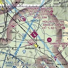
| Sectional chart |
|---|
|
| Airport distance calculator |
|---|
|
|
| Sunrise and sunset |
|---|
|
Times for 11-Jan-2026
| | Local
(UTC-8) | | Zulu
(UTC) |
|---|
| Morning civil twilight | | 06:51 | | 14:51 |
| Sunrise | | 07:20 | | 15:20 |
| Sunset | | 17:08 | | 01:08 |
| Evening civil twilight | | 17:36 | | 01:36 |
|
| Current date and time |
|---|
| Zulu (UTC) | 11-Jan-2026 20:30:26 |
|---|
| Local (UTC-8) | 11-Jan-2026 12:30:26 |
|---|
|
| METAR |
|---|
| KCVH | 112015Z AUTO 00000KT 10SM CLR 13/04 A3035 RMK A01
|
KE16
14nm NW | 111955Z AUTO 34008KT 10SM CLR 14/02 A3037 RMK AO2
|
KSNS
16nm SW | 111953Z 12006KT 10SM CLR 15/02 A3034 RMK AO2 SLP282 T01500017
|
KWVI
18nm W | 111953Z AUTO 12004KT 10SM CLR 17/03 A3034 RMK AO2 SLP273 T01720033
|
|
| TAF |
|---|
KSNS
16nm SW | 111728Z 1118/1218 12010KT P6SM SCT250 FM112300 VRB05KT P6SM SCT250 FM120500 11007KT P6SM SCT250
|
|
| NOTAMs |
|---|
NOTAMs are issued by the DoD/FAA and will open in a separate window not controlled by AirNav.
|
|


