FAA INFORMATION EFFECTIVE 10 JULY 2025
Location
| FAA Identifier: | DAN |
| Lat/Long: | 36-34-20.9000N 079-20-10.5000W
36-34.348333N 079-20.175000W
36.5724722,-79.3362500
(estimated) |
| Elevation: | 571.1 ft. / 174.1 m (surveyed) |
| Variation: | 09W (2010) |
| From city: | 3 miles E of DANVILLE, VA |
| Time zone: | UTC -4 (UTC -5 during Standard Time) |
| Zip code: | 24586 |
Airport Operations
| Airport use: | Open to the public |
| Activation date: | 10/1937 |
| Control tower: | no |
| ARTCC: | WASHINGTON CENTER |
| FSS: | LEESBURG FLIGHT SERVICE STATION |
| NOTAMs facility: | DAN (NOTAM-D service available) |
| Attendance: | MON-FRI 0700-1900, ALL SAT-SUN 0700-1900
ARPT UNATTND CHRISTMAS DAY |
| Pattern altitude: | TPA 800 FT AGL LGT ACFT; 1500 FT AGL TURBINE ACFT. |
| Wind indicator: | lighted |
| Segmented circle: | yes |
| Lights: | ACTVT HIRL RY 02/20, MIRL RY 13/31, REIL RYS 13, 31, & 20, MALSR RY 02, VASI RY 13, & PAPIS RYS 02, 20, & 31 - CTAF. |
| Beacon: | white-green (lighted land airport)
Operates sunset to sunrise. |
Airport Communications
| CTAF/UNICOM: | 123.05 |
| WX ASOS: | 128.125 (434-799-1701) |
- APCH/DEP SVC PRVDD BY WASHINGTON ARTCC ON FREQS 124.05/352.0 (SOUTH BOSTON RCAG).
Nearby radio navigation aids
| VOR radial/distance | | VOR name | | Freq | | Var |
|---|
| SBVr253/16.7 | | SOUTH BOSTON VORTAC | | 110.40 | | 05W |
| NDB name | | Hdg/Dist | | Freq | | Var | | ID |
|---|
| SLAMMER | | 068/23.5 | | 423 | | 07W | | SIF | ... .. ..-. |
| HUNTSBORO | | 304/38.3 | | 271 | | 09W | | HXO | .... -..- --- |
Airport Services
| Fuel available: | 100LL JET-A+ |
| Parking: | hangars and tiedowns |
| Airframe service: | MAJOR |
| Powerplant service: | MAJOR |
| Bottled oxygen: | NONE |
| Bulk oxygen: | NONE |
Runway Information
Runway 2/20
| Dimensions: | 5900 x 100 ft. / 1798 x 30 m |
| Surface: | asphalt/grooved, in good condition |
| Weight bearing capacity: | | Single wheel: | 90.0 | | Double wheel: | 130.0 |
|
| Runway edge lights: | high intensity |
| RUNWAY 2 | | RUNWAY 20 |
| Latitude: | 36-33.775873N | | 36-34.708968N |
| Longitude: | 079-20.488862W | | 079-20.150287W |
| Elevation: | 535.6 ft. | | 564.6 ft. |
| Traffic pattern: | left | | left |
| Runway heading: | 025 magnetic, 016 true | | 205 magnetic, 196 true |
| Displaced threshold: | no | | 300 ft. |
| Declared distances: | TORA:5600 TODA:5900 ASDA:5600 LDA:5600 | | TORA:5900 TODA:5900 ASDA:5900 LDA:5600 |
| Markings: | precision, in good condition | | nonprecision, in good condition |
| Visual slope indicator: | 4-light PAPI on left (3.00 degrees glide path) | | 4-light PAPI on left (3.00 degrees glide path) |
| Approach lights: | MALSR: 1,400 foot medium intensity approach lighting system with runway alignment indicator lights | | |
| Runway end identifier lights: | | | yes |
| Touchdown point: | yes, no lights | | yes, no lights |
| Instrument approach: | ILS | | |
| Obstructions: | 53 ft. tree, 2255 ft. from runway, 750 ft. left of centerline, 38:1 slope to clear | | 129 ft. tree, 4436 ft. from runway, 552 ft. right of centerline, 32:1 slope to clear
SLP TO DTHR 39:1. |
Runway 13/31
| Dimensions: | 3910 x 100 ft. / 1192 x 30 m |
| Surface: | asphalt, in good condition |
| Weight bearing capacity: | | Single wheel: | 90.0 | | Double wheel: | 130.0 |
|
| Runway edge lights: | medium intensity |
| RUNWAY 13 | | RUNWAY 31 |
| Latitude: | 36-34.691188N | | 36-34.325965N |
| Longitude: | 079-20.284113W | | 079-19.625885W |
| Elevation: | 571.1 ft. | | 527.8 ft. |
| Traffic pattern: | left | | left |
| Runway heading: | 134 magnetic, 125 true | | 314 magnetic, 305 true |
| Markings: | basic, in good condition | | nonprecision, in good condition |
| Visual slope indicator: | 2-box VASI on left (3.00 degrees glide path) | | 2-light PAPI on left (4.00 degrees glide path) |
| Runway end identifier lights: | yes | | yes |
| Touchdown point: | yes, no lights | | yes, no lights |
| Obstructions: | 120 ft. tree, 2708 ft. from runway, 429 ft. left of centerline, 20:1 slope to clear | | 19 ft. trees, 464 ft. from runway, 61 ft. left of centerline, 13:1 slope to clear |
Airport Ownership and Management from official FAA records
| Ownership: | Publicly-owned |
| Owner: | CITY OF DANVILLE
PO BOX 3300
DANVILLE, VA 24543
Phone 434-799-5110 |
| Manager: | MARC ADELMAN
424 AIRPORT DRIVE
DANVILLE, VA 24540
Phone 434-799-5110 |
Additional Remarks
| - | BIRDS & DEER ON & INVOF ARPT. |
| - | RY 02 IS DESIGNATED CALM WIND RY. |
| - | CTC ARPT ADMIN PRIOR TO CONDUCTING SPECIALIZED AERO ACTIVITIES 434-799-5110. |
| - | TREES PENETRATING 7:1 TRANSITIONAL SURFACE, RY 31 BOTH SIDES, FIRST 1000 FT. |
| - | FOR CD IF UNA TO CTC ON FSS FREQ, CTC WASHINGTON ARTCC AT 703-771-3587. |
Instrument Procedures
NOTE: All procedures below are presented as PDF files. If you need a reader for these files, you should download the free Adobe Reader.NOT FOR NAVIGATION. Please procure official charts for flight.
FAA instrument procedures published for use from 10 July 2025 at 0901Z to 07 August 2025 at 0900z.
IAPs - Instrument Approach Procedures |
|---|
| ILS OR LOC RWY 02 | |
download (223KB) |
| RNAV (GPS) RWY 02 | |
download (218KB) |
| RNAV (GPS) RWY 20 | |
download (234KB) |
| RNAV (GPS) RWY 31 | |
download (188KB) |
| NOTE: Special Alternate Minimums apply | |
download (147KB) |
| NOTE: Special Take-Off Minimums/Departure Procedures apply | |
download (219KB) |
Other nearby airports with instrument procedures:
KTDF - Raleigh Regional Airport at Person County (24 nm SE)
W78 - William M Tuck Airport (25 nm E)
KSIF - Rockingham County NC Shiloh Airport (26 nm W)
KBUY - Burlington/Alamance Regional Airport (32 nm S)
KMTV - Blue Ridge Airport (33 nm W)
|
|

Road maps at:
MapQuest
Bing
Google
| Aerial photo |
|---|
WARNING: Photo may not be current or correct
 Photo courtesy of AirNav, LLC
Photo taken 03-Nov-2013
looking northwest.
Photo courtesy of AirNav, LLC
Photo taken 03-Nov-2013
looking northwest.
Do you have a better or more recent aerial photo of Danville Regional Airport that you would like to share? If so, please send us your photo.
|
| Sectional chart |
|---|
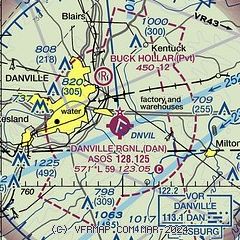
|
| Airport distance calculator |
|---|
|
|
| Sunrise and sunset |
|---|
|
Times for 12-Jul-2025
| | Local
(UTC-4) | | Zulu
(UTC) |
|---|
| Morning civil twilight | | 05:40 | | 09:40 |
| Sunrise | | 06:10 | | 10:10 |
| Sunset | | 20:36 | | 00:36 |
| Evening civil twilight | | 21:06 | | 01:06 |
|
| Current date and time |
|---|
| Zulu (UTC) | 12-Jul-2025 10:33:46 |
|---|
| Local (UTC-4) | 12-Jul-2025 06:33:46 |
|---|
|
| METAR |
|---|
| KDAN | 121020Z AUTO 00000KT 1/4SM FG VV001 22/22 A3005 RMK AO2 T02170217
|
|
| TAF |
|---|
| KDAN | 120520Z 1206/1306 00000KT P6SM SKC FM120800 VRB01KT 3SM BR SCT250 FM121200 20005KT P6SM SCT050 FM122300 19003KT 6SM -TSRA BKN040CB FM130200 18001KT P6SM BKN100
|
|
| NOTAMs |
|---|
NOTAMs are issued by the DoD/FAA and will open in a separate window not controlled by AirNav.
|
|


