FAA INFORMATION EFFECTIVE 04 SEPTEMBER 2025
Location
| FAA Identifier: | DHT |
| Lat/Long: | 36-01-20.9000N 102-32-50.6000W
36-01.348333N 102-32.843333W
36.0224722,-102.5473889
(estimated) |
| Elevation: | 3991.1 ft. / 1216.5 m (surveyed) |
| Variation: | 09E (1995) |
| From city: | 3 miles SW of DALHART, TX |
| Time zone: | UTC -5 (UTC -6 during Standard Time) |
| Zip code: | 79022 |
Airport Operations
| Airport use: | Open to the public |
| Activation date: | 07/1943 |
| Control tower: | no |
| ARTCC: | ALBUQUERQUE CENTER |
| FSS: | FORT WORTH FLIGHT SERVICE STATION |
| NOTAMs facility: | DHT (NOTAM-D service available) |
| Attendance: | 0800-1900 |
| Wind indicator: | lighted |
| Segmented circle: | yes |
| Lights: | MIRL RWYS 03/21 & 17/35 PRESET LOW INTST; TO INCR INTST & ACTVT PAPI RWYS 17 & 35 - CTAF. |
| Beacon: | white-green (lighted land airport)
Operates sunset to sunrise. |
Airport Communications
| CTAF/UNICOM: | 122.95 |
| WX ASOS: | 134.075 (806-249-5671) |
- APCH/DEP SVC PRVDD BY ALBUQUERQUE ARTCC (ZAB) ON FREQS 127.85/285.475 (AMARILLO RCAG).
Nearby radio navigation aids
| VOR radial/distance | | VOR name | | Freq | | Var |
|---|
| DHTr170/4.1 | | DALHART VORTAC | | 112.00 | | 12E |
Airport Services
| Fuel available: | 100LL JET-A1
100LL:FOR JET A AFT HRS CALL 806-244-5521 DURG BUS HRS. 100 LL FULL & SELF SERVE. |
| Parking: | hangars and tiedowns |
| Airframe service: | MAJOR |
| Powerplant service: | MAJOR |
| Bottled oxygen: | NONE |
| Bulk oxygen: | NONE |
Runway Information
Runway 17/35
| Dimensions: | 6400 x 75 ft. / 1951 x 23 m |
| Surface: | asphalt, in fair condition |
| Weight bearing capacity: | | Single wheel: | 20.0 | | Double wheel: | 30.0 |
|
| Runway edge lights: | medium intensity |
| RUNWAY 17 | | RUNWAY 35 |
| Latitude: | 36-01.867160N | | 36-00.812482N |
| Longitude: | 102-32.785125W | | 102-32.781797W |
| Elevation: | 3991.0 ft. | | 3986.7 ft. |
| Traffic pattern: | left | | left |
| Runway heading: | 171 magnetic, 180 true | | 351 magnetic, 360 true |
| Markings: | nonprecision, in fair condition | | nonprecision, in fair condition |
| Visual slope indicator: | 4-light PAPI on left (3.00 degrees glide path) | | 4-light PAPI on left (3.00 degrees glide path) |
| Runway end identifier lights: | yes | | yes |
| Touchdown point: | yes, no lights | | yes, no lights |
Runway 3/21
| Dimensions: | 5440 x 75 ft. / 1658 x 23 m |
| Surface: | asphalt, in excellent condition |
| Weight bearing capacity: | |
| Runway edge lights: | medium intensity |
| RUNWAY 3 | | RUNWAY 21 |
| Latitude: | 36-01.041022N | | 36-01.676695N |
| Longitude: | 102-33.302372W | | 102-32.524210W |
| Elevation: | 3983.2 ft. | | 3982.3 ft. |
| Traffic pattern: | left | | left |
| Runway heading: | 036 magnetic, 045 true | | 216 magnetic, 225 true |
| Markings: | nonprecision, in good condition | | nonprecision, in good condition |
| Touchdown point: | yes, no lights | | yes, no lights |
| Obstructions: | 18 ft. tree, 740 ft. from runway, 125 ft. right of centerline, 30:1 slope to clear | | 7 ft. ant, 271 ft. from runway, 227 ft. right of centerline, 10:1 slope to clear |
Airport Ownership and Management from official FAA records
| Ownership: | Publicly-owned |
| Owner: | CITY OF DALHART
PO BOX 2005
DALHART, TX 79022
Phone 806-244-5511 |
| Manager: | JOE LIVINGSTON
PO BOX 2005, 205 ROCK ISLAND AVE.
DALHART, TX 79022
Phone 806-244-5521
ARPT ATTENDANT/FBO. |
Additional Remarks
| - | LARGE FLOCKS OF WATERFOWL INVOF LAKE RITA BLANCA 2 MI EAST SPRING & FALL. |
| - | FOR CD IF UNA TO CTC ON FSS FREQ, CTC ALBUQUERQUE ARTCC AT 505-856-4561. |
Instrument Procedures
NOTE: All procedures below are presented as PDF files. If you need a reader for these files, you should download the free Adobe Reader.NOT FOR NAVIGATION. Please procure official charts for flight.
FAA instrument procedures published for use from 04 September 2025 at 0901Z to 02 October 2025 at 0900z.
IAPs - Instrument Approach Procedures |
|---|
| RNAV (GPS) RWY 17 | |
download (193KB) |
| RNAV (GPS) RWY 35 | |
download (214KB) |
| VOR/DME RWY 35 | |
download (182KB) |
| VOR RWY 17 | |
download (183KB) |
| NOTE: Special Alternate Minimums apply | |
download (29KB) |
| NOTE: Special Take-Off Minimums/Departure Procedures apply | |
download (199KB) |
Other nearby airports with instrument procedures:
KDUX - Moore County Airport (28 nm E)
KCAO - Clayton Municipal Airpark (39 nm NW)
17K - Boise City Airport (45 nm N)
E19 - Gruver Municipal Airport (56 nm E)
KBGD - Hutchinson County Airport (59 nm E)
|
|

Road maps at:
MapQuest
Bing
Google
| Aerial photo |
|---|
WARNING: Photo may not be current or correct
 Photo by Judy Mitchell
Photo taken 25-Oct-2006
Photo by Judy Mitchell
Photo taken 25-Oct-2006
Do you have a better or more recent aerial photo of Dalhart Municipal Airport that you would like to share? If so, please send us your photo.
|
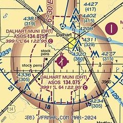
| Sectional chart |
|---|
|
| Airport distance calculator |
|---|
|
|
| Sunrise and sunset |
|---|
|
Times for 24-Sep-2025
| | Local
(UTC-5) | | Zulu
(UTC) |
|---|
| Morning civil twilight | | 07:15 | | 12:15 |
| Sunrise | | 07:41 | | 12:41 |
| Sunset | | 19:44 | | 00:44 |
| Evening civil twilight | | 20:09 | | 01:09 |
|
| Current date and time |
|---|
| Zulu (UTC) | 24-Sep-2025 12:54:10 |
|---|
| Local (UTC-5) | 24-Sep-2025 07:54:10 |
|---|
|
| METAR |
|---|
| KDHT | 241230Z AUTO 35011G20KT 10SM SCT020 13/10 A3028 RMK AO2 T01280100
|
|
| TAF |
|---|
| KDHT | 241126Z 2412/2512 33012KT P6SM BKN020 FM241400 36018G28KT P6SM BKN020 FM241600 36018G28KT P6SM BKN050 FM242200 01010KT P6SM FEW250 FM250200 VRB05KT P6SM SKC
|
|
| NOTAMs |
|---|
NOTAMs are issued by the DoD/FAA and will open in a separate window not controlled by AirNav.
|
|


