FAA INFORMATION EFFECTIVE 22 JANUARY 2026
Location
| FAA Identifier: | DIK |
| Lat/Long: | 46-48-01.7050N 102-48-15.9670W
46-48.028417N 102-48.266117W
46.8004736,-102.8044353
(estimated) |
| Elevation: | 2592.1 ft. / 790.1 m (surveyed) |
| Variation: | 10E (2000) |
| From city: | 5 miles S of DICKINSON, ND |
| Time zone: | UTC -7 (UTC -6 during Daylight Saving Time) |
| Zip code: | 58601 |
Airport Operations
| Airport use: | Open to the public |
| Activation date: | 10/1938 |
| Control tower: | no |
| ARTCC: | MINNEAPOLIS CENTER |
| FSS: | GRAND FORKS FLIGHT SERVICE STATION |
| NOTAMs facility: | DIK (NOTAM-D service available) |
| Attendance: | 0700-1600
FOR SVC AFT HRS CALL 701-264-9966. |
| Pattern altitude: | 3602.1 ft. MSL
TPA SNGL ENG 1010 FT AGL; MULT ENG 1510 FT AGL. |
| Wind indicator: | lighted |
| Segmented circle: | yes |
| Lights: | ACTVT MALSR RWY 32; REIL RWY 14, 07 & 25; PAPI RWY 14 & 32; HIRL RWY 14/32 - CTAF. PAPI RWY 07 & 25 OPR CONSLY SS-SR. MIRL RWY 07/25 PRESET ON LOW INTST DUSK-2200; TO INCR INTST AFT 2200 - CTAF. |
| Beacon: | white-green (lighted land airport)
Operates sunset to sunrise. |
| Fire and rescue: | ARFF index A |
Airport Communications
| CTAF/UNICOM: | 123.0 |
| WX ASOS: | 118.375 (701-227-0280) |
- APCH/DEP SVC PRVDD BY MINNEAPOLIS ARTCC ON FREQS 124.25/236.825 (DICKINSON RCAG).
- COMMUNICATIONS PRVDD BY GRAND FORKS RADIO ON FREQ 122.2 (DICKINSON RCO).
Nearby radio navigation aids
| VOR radial/distance | | VOR name | | Freq | | Var |
|---|
| DIKr186/3.8 | | DICKINSON VORTAC | | 112.90 | | 14E |
Airport Services
| Fuel available: | 100LL JET-A |
| Parking: | hangars and tiedowns |
| Airframe service: | MAJOR |
| Powerplant service: | MAJOR |
| Bottled oxygen: | NONE |
| Bulk oxygen: | NONE |
Runway Information
Runway 14/32
| Dimensions: | 7301 x 150 ft. / 2225 x 46 m |
| Surface: | concrete/grooved, in excellent condition |
| Weight bearing capacity: | | Single wheel: | 60.0 | | Double wheel: | 90.0 | | Double tandem: | 90.0 |
|
| Runway edge lights: | high intensity |
| RUNWAY 14 | | RUNWAY 32 |
| Latitude: | 46-48.669395N | | 46-47.625230N |
| Longitude: | 102-48.775510W | | 102-47.911370W |
| Elevation: | 2581.8 ft. | | 2581.5 ft. |
| Traffic pattern: | left | | left |
| Runway heading: | 140 magnetic, 150 true | | 320 magnetic, 330 true |
| Declared distances: | TORA:7301 TODA:7301 ASDA:7301 LDA:7301 | | TORA:7301 TODA:7301 ASDA:7301 LDA:7301 |
| Markings: | precision, in good condition | | precision, in good condition |
| Visual slope indicator: | 4-light PAPI on left (3.00 degrees glide path) | | 4-light PAPI on left (3.00 degrees glide path) |
| Approach lights: | | | MALSR: 1,400 foot medium intensity approach lighting system with runway alignment indicator lights |
| Runway end identifier lights: | yes | | no |
| Touchdown point: | yes, no lights | | yes, no lights |
| Instrument approach: | | | ILS/DME |
| Obstructions: | 65 ft. pole, 2686 ft. from runway, 676 ft. left of centerline, 38:1 slope to clear | | 37 ft. road, 2344 ft. from runway, 666 ft. right of centerline |
Runway 7/25
| Dimensions: | 4700 x 75 ft. / 1433 x 23 m |
| Surface: | asphalt/grooved, in good condition |
| Weight bearing capacity: | | Single wheel: | 16.0 | | Double wheel: | 20.0 |
|
| Runway edge lights: | medium intensity |
| Operational restrictions: | RWY 07/25 NOT AVBL FOR PART 121/PART 380 OPS WITH SKED PAX CARRYING OPS MORE THAN 9 PAX SEATS AND NON-SKED PAX CARRYING OPS MORE THAN 30 PAX SEATS. |
| RUNWAY 7 | | RUNWAY 25 |
| Latitude: | 46-47.774773N | | 46-47.912573N |
| Longitude: | 102-48.699935W | | 102-47.592285W |
| Elevation: | 2571.7 ft. | | 2592.1 ft. |
| Traffic pattern: | left | | left |
| Runway heading: | 070 magnetic, 080 true | | 250 magnetic, 260 true |
| Declared distances: | TORA:4700 TODA:4700 ASDA:4700 LDA:4700 | | TORA:4700 TODA:4700 ASDA:4700 LDA:4700 |
| Markings: | nonprecision, in fair condition | | nonprecision, in good condition |
| Visual slope indicator: | 4-light PAPI on left (3.00 degrees glide path) | | 4-light PAPI on left (3.00 degrees glide path) |
| Runway end identifier lights: | yes | | yes |
| Touchdown point: | yes, no lights | | yes, no lights |
| Obstructions: | none | | 28 ft. road, 790 ft. from runway, 300 ft. left of centerline, 21:1 slope to clear |
Airport Ownership and Management from official FAA records
| Ownership: | Publicly-owned |
| Owner: | DICKINSON ARPT AUTHORITY
11120 42ND ST SW
DICKINSON, ND 58601-9282
Phone 701-483-1062 |
| Manager: | KELLY BRAUN
11120 42ND ST SW
DICKINSON, ND 58601-9282
Phone 701-483-1062 |
Additional Remarks
| A39-14/32 | PCR VALUE: 440/R/D/W/T |
| A39-07/25 | PCR VALUE: 60/F/D/X/T |
| - | HAYING OPNS ADJ TO ALL SFCS JUN - SEP. |
| - | CROP DUSTING OPNS INVOF ARPT. |
| - | PAEW ON MOVEMENT AREAS DURG WINTER (OCT-APR). |
| - | AIRFIELD SFC CONDS UNMON BTN 2300-0430. |
| - | FOR CD IF UNA TO CTC ON FSS FREQ, CTC MINNEAPOLIS ARTCC AT 651-463-5588. |
| - | CONC APRON FOR HEAVY ACFT PARKING. |
Instrument Procedures
NOTE: All procedures below are presented as PDF files. If you need a reader for these files, you should download the free Adobe Reader.NOT FOR NAVIGATION. Please procure official charts for flight.
FAA instrument procedures published for use from 22 January 2026 at 0901Z to 19 February 2026 at 0900z.
IAPs - Instrument Approach Procedures |
|---|
| ILS OR LOC RWY 32 | |
download (231KB) |
| RNAV (GPS) RWY 07 | |
download (234KB) |
| RNAV (GPS) RWY 14 | |
download (213KB) |
| RNAV (GPS) RWY 25 | |
download (220KB) |
| RNAV (GPS) RWY 32 | |
download (228KB) |
| VOR-A | |
download (191KB) |
| NOTE: Special Alternate Minimums apply | |
download (175KB) |
| NOTE: Special Take-Off Minimums/Departure Procedures apply | |
download (406KB) |
Other nearby airports with instrument procedures:
3P3 - Mott Municipal Airport (33 nm SE)
9Y1 - Dunn County Airport - Weydahl Field (35 nm N)
D57 - Glen Ullin Regional Airport (39 nm E)
KBWW - Bowman Regional Airport (43 nm SW)
KHEI - Hettinger/JB Lindquist Regional Airport (48 nm S)
|
|

Road maps at:
MapQuest
Bing
Google
| Aerial photo |
|---|
WARNING: Photo may not be current or correct
 Photo taken 26-Jan-2007
from FL370
Photo taken 26-Jan-2007
from FL370
Do you have a better or more recent aerial photo of Dickinson/Theodore Roosevelt Regional Airport that you would like to share? If so, please send us your photo.
|
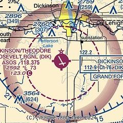
| Sectional chart |
|---|
|
| Airport distance calculator |
|---|
|
|
| Sunrise and sunset |
|---|
|
Times for 07-Feb-2026
| | Local
(UTC-7) | | Zulu
(UTC) |
|---|
| Morning civil twilight | | 06:37 | | 13:37 |
| Sunrise | | 07:09 | | 14:09 |
| Sunset | | 17:02 | | 00:02 |
| Evening civil twilight | | 17:34 | | 00:34 |
|
| Current date and time |
|---|
| Zulu (UTC) | 07-Feb-2026 22:34:26 |
|---|
| Local (UTC-7) | 07-Feb-2026 15:34:26 |
|---|
|
| METAR |
|---|
| KDIK | 072156Z AUTO 28011KT 10SM CLR 08/01 A2985 RMK AO2 PK WND 28026/2058 SLP125 T00780006
|
|
| TAF |
|---|
| KDIK | 071728Z 0718/0818 30014KT P6SM FEW250 FM080400 28009KT P6SM FEW250 FM081700 27015KT P6SM FEW200
|
|
| NOTAMs |
|---|
NOTAMs are issued by the DoD/FAA and will open in a separate window not controlled by AirNav.
|
|


