FAA INFORMATION EFFECTIVE 11 JUNE 2026
Location
| FAA Identifier: | DRM |
| Lat/Long: | 46-00-33.5210N 083-44-38.1630W
46-00.558683N 083-44.636050W
46.0093114,-83.7439342
(estimated) |
| Elevation: | 668.4 ft. / 203.7 m (surveyed) |
| Variation: | 07W (1995) |
| From city: | 1 mile SW of DRUMMOND ISLAND, MI |
| Time zone: | UTC -4 (UTC -5 during Standard Time) |
| Zip code: | 49726 |
Airport Operations
| Airport use: | Open to the public |
| Activation date: | 08/1948 |
| Control tower: | no |
| ARTCC: | TORONTO CENTER |
| FSS: | GREEN BAY FLIGHT SERVICE STATION |
| NOTAMs facility: | DRM (NOTAM-D service available) |
| Attendance: | MON-SAT 0800-1700 |
| Wind indicator: | lighted |
| Segmented circle: | yes |
| Lights: | ACTVT PAPI RWY 08 & 26; MIRL RWY 08/26 - CTAF. |
| Beacon: | white-green (lighted land airport)
Operates sunset to sunrise. |
Airport Communications
| CTAF/UNICOM: | 122.8 |
| WX AWOS-3P: | 118.325 (906-493-6410) |
- APCH/DEP SVC PRVDD BY TORONTO CENTRE ON 132.65/344.5.
Nearby radio navigation aids
| VOR radial/distance | | VOR name | | Freq | | Var |
|---|
| SSMr140/33.9 | | SAULT STE MARIE VOR/DME | | 112.20 | | 04W |
Airport Services
| Fuel available: | 100LL MOGAS |
| Parking: | tiedowns |
Runway Information
Runway 8/26
| Dimensions: | 4000 x 75 ft. / 1219 x 23 m |
| Surface: | asphalt, in fair condition |
| Runway edge lights: | medium intensity |
| RUNWAY 8 | | RUNWAY 26 |
| Latitude: | 46-00.417033N | | 46-00.619233N |
| Longitude: | 083-45.238367W | | 083-44.339633W |
| Elevation: | 659.4 ft. | | 657.4 ft. |
| Traffic pattern: | left | | left |
| Runway heading: | 079 magnetic, 072 true | | 259 magnetic, 252 true |
| Displaced threshold: | 650 ft. | | 170 ft. |
| Markings: | nonprecision, in fair condition | | nonprecision, in fair condition |
| Visual slope indicator: | 2-light PAPI on left (3.00 degrees glide path) | | 2-light PAPI on left (3.00 degrees glide path) |
| Touchdown point: | yes, no lights | | yes, no lights |
| Obstructions: | 42 ft. trees, 200 ft. from runway, 181 ft. left of centerline
+4 FT FENCE, 20 FT DIST; +10 FT HILL, 10 FT DIST, 50 FT L; +18 FT BLDG, 97 FT DIST, 50 FT R; +50 FT TREES, 20 FT DIST, 90 FT L/R. | | 15 ft. road, 200 ft. from runway, 125 ft. right of centerline, 1:1 slope to clear
+6 FT FENCE, 54 FT DIST; +15 FT ROAD, 112 FT DIST; +20 FT BLDG, 0 FT DIST, 200 FT R. |
Runway 1/19
| Dimensions: | 2500 x 150 ft. / 762 x 46 m |
| Surface: | asphalt/turf, in fair condition
CNTR 20 FT OF RWY FM INT RWY 08/26 NORTH TO THE HNGR LINE IS ASPH, RMNDR OF RWY TURF. |
| Runway edge markings: | 3 FT YELLOW CONES. |
| RUNWAY 1 | | RUNWAY 19 |
| Latitude: | 46-00.417933N | | 46-00.829117N |
| Longitude: | 083-44.383500W | | 083-44.398950W |
| Traffic pattern: | left | | left |
| Runway heading: | 005 magnetic, 358 true | | 185 magnetic, 178 true |
| Obstructions: | 48 ft. trees, 125 ft. right of centerline
CTLG OBSTN EXCEEDS A 45 DEG SLP. | | 73 ft. trees, 125 ft. left of centerline
CTLG OBSTN EXCEEDS A 45 DEG SLP. |
Airport Ownership and Management from official FAA records
| Ownership: | Publicly-owned |
| Owner: | DRUMMOND TOWNSHIP
PO BOX 245
DRUMMOND ISLAND, MI 49726-0245
Phone 906-493-5321 |
| Manager: | JAMES BAILEY II
34264 S TOWNLINE RD
DRUMMOND ISLAND, MI 49726-9636
Phone 906-493-5411 |
Additional Remarks
| - | GOLF CARTS & PEDESTRIANS XNG RWY 08/26 DUE TO GOLF CRS ON BOTH SIDES. |
| - | DEER, BIRDS, & WILDLIFE ON & INVOF ARPT. |
| - | D22 SPB LCTD 1.5 NM NORTH. |
| - | FOR CD CTC MINNEAPOLIS ARTCC AT 651-463-5588. |
Instrument Procedures
NOTE: All procedures below are presented as PDF files. If you need a reader for these files, you should download the free Adobe Reader.NOT FOR NAVIGATION. Please procure official charts for flight.
FAA instrument procedures published for use from 11 June 2026 at 0901Z to 09 July 2026 at 0900z.
IAPs - Instrument Approach Procedures |
|---|
| RNAV (GPS) RWY 08 | |
download (208KB) |
| RNAV (GPS) RWY 26 | |
download (206KB) |
| NOTE: Special Take-Off Minimums/Departure Procedures apply | |
download (122KB) |
Other nearby airports with instrument procedures:
KCIU - Chippewa County International Airport (34 nm NW)
6Y1 - Bois Blanc Island Airport (35 nm SW)
KPZQ - Presque Isle County Airport (36 nm S)
KMCD - Mackinac Island Airport (38 nm W)
KANJ - Sault Ste Marie Municipal Airport/Sanderson Field (38 nm NW)
|
|

Road maps at:
MapQuest
Bing
Google
| Aerial photo |
|---|
WARNING: Photo may not be current or correct
 Photo by Bob Patterson
Taken in the Summer of 2003
Photo by Bob Patterson
Taken in the Summer of 2003
Do you have a better or more recent aerial photo of Drummond Island Airport that you would like to share? If so, please send us your photo.
|
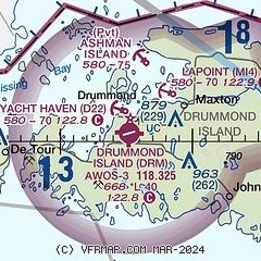
| Sectional chart |
|---|
|
| Airport distance calculator |
|---|
|
|
| Sunrise and sunset |
|---|
|
Times for 18-Jun-2026
| | Local
(UTC-4) | | Zulu
(UTC) |
|---|
| Morning civil twilight | | 05:06 | | 09:06 |
| Sunrise | | 05:45 | | 09:45 |
| Sunset | | 21:28 | | 01:28 |
| Evening civil twilight | | 22:06 | | 02:06 |
|
| Current date and time |
|---|
| Zulu (UTC) | 18-Jun-2026 05:20:17 |
|---|
| Local (UTC-4) | 18-Jun-2026 01:20:17 |
|---|
|
| METAR |
|---|
| KDRM | 180455Z AUTO 10003KT 10SM SCT006 SCT060 OVC085 12/12 A2944 RMK AO2 T01220116
|
|
| TAF |
|---|
KCIU
33nm NW | 171730Z 1718/1818 18007KT P6SM SCT030 BKN090 FM172100 11004KT P6SM OVC045 FM180100 10005KT 6SM -SHRA BR OVC015 FM180300 10005KT 4SM -SHRA BR OVC008 FM181500 32010KT 6SM -RA OVC015
|
|
| NOTAMs |
|---|
NOTAMs are issued by the DoD/FAA and will open in a separate window not controlled by AirNav.
|
|

