FAA INFORMATION EFFECTIVE 09 JULY 2026
Location
| FAA Identifier: | DUX |
| Lat/Long: | 35-51-26.7504N 102-00-47.9133W
35-51.445840N 102-00.798555W
35.8574307,-102.0133093
(estimated) |
| Elevation: | 3706.4 ft. / 1129.7 m (surveyed) |
| Variation: | 09E (1990) |
| From city: | 2 miles W of DUMAS, TX |
| Time zone: | UTC -5 (UTC -6 during Standard Time) |
| Zip code: | 79029 |
Airport Operations
| Airport use: | Open to the public |
| Activation date: | 08/1955 |
| Control tower: | no |
| ARTCC: | ALBUQUERQUE CENTER |
| FSS: | FORT WORTH FLIGHT SERVICE STATION |
| NOTAMs facility: | DUX (NOTAM-D service available) |
| Attendance: | 0800-1700
FOR SVCS AFT HRS CALL 806-935-6995. |
| Wind indicator: | lighted |
| Segmented circle: | yes |
| Lights: | MIRL RWY 01/19 PRESET LOW INTST; TO INCR INTST ACTVT - CTAF. PAPI RWY 01 & 19 OPR CONSLY. |
| Beacon: | white-green (lighted land airport)
Operates sunset to sunrise. |
Airport Communications
| CTAF/UNICOM: | 122.8 |
| WX AWOS-3PT: | 118.075 (806-934-3390) |
- APCH/DEP SVC PRVDD BY ALBUQUERQUE ARTCC (ZAB) ON FREQS 127.85/285.475 (AMARILLO RCAG).
Nearby radio navigation aids
| VOR radial/distance | | VOR name | | Freq | | Var |
|---|
| DHTr107/29.4 | | DALHART VORTAC | | 112.00 | | 12E |
Airport Services
| Fuel available: | 100LL JET-A
100LL:100 LL SELF-SERVE FUEL AVBL 24 HRS. |
| Parking: | hangars and tiedowns |
| Airframe service: | MAJOR |
| Powerplant service: | MAJOR |
| Bottled oxygen: | NONE |
| Bulk oxygen: | NONE |
Runway Information
Runway 1/19
| Dimensions: | 6001 x 100 ft. / 1829 x 30 m |
| Surface: | asphalt, in good condition |
| Weight bearing capacity: | | Single wheel: | 30.0 | | Double wheel: | 45.0 |
|
| Runway edge lights: | medium intensity |
| RUNWAY 1 | | RUNWAY 19 |
| Latitude: | 35-50.927335N | | 35-51.836928N |
| Longitude: | 102-01.057398W | | 102-00.579867W |
| Elevation: | 3706.4 ft. | | 3698.1 ft. |
| Traffic pattern: | left | | left |
| Runway heading: | 014 magnetic, 023 true | | 194 magnetic, 203 true |
| Markings: | nonprecision, in good condition | | nonprecision, in good condition |
| Visual slope indicator: | 4-light PAPI on left (3.00 degrees glide path) | | 4-light PAPI on left (3.00 degrees glide path) |
| Touchdown point: | yes, no lights | | yes, no lights |
| Obstructions: | none | | 15 ft. road, 500 ft. from runway, 295 ft. right of centerline, 20:1 slope to clear |
Runway 14/32
| Dimensions: | 3100 x 60 ft. / 945 x 18 m |
| Surface: | asphalt, in fair condition |
| Weight bearing capacity: | | Single wheel: | 21.0 | | Double wheel: | 32.0 |
|
| Runway edge lights: | medium intensity |
| RUNWAY 14 | | RUNWAY 32 |
| Latitude: | 35-51.793745N | | 35-51.344585N |
| Longitude: | 102-00.909078W | | 102-00.610303W |
| Elevation: | 3698.5 ft. | | 3700.1 ft. |
| Traffic pattern: | left | | left |
| Runway heading: | 143 magnetic, 152 true | | 323 magnetic, 332 true |
| Markings: | basic, in fair condition | | basic, in fair condition |
| Touchdown point: | yes, no lights | | yes, no lights |
| Obstructions: | 29 ft. pline, 790 ft. from runway, 190 ft. left of centerline, 20:1 slope to clear | | none |
Airport Ownership and Management from official FAA records
| Ownership: | Publicly-owned |
| Owner: | MOORE COUNTY
715 DUMAS AVE. RM 202
DUMAS, TX 79029
Phone 806-935-5588 |
| Manager: | DON WILLINGHAM
5932 US 87
DUMAS, TX 79029
Phone 806-935-6995 |
Additional Remarks
| - | EXTSV CROP DUSTING MAR-SEP. |
| - | FOR CD CTC ALBUQUERQUE ARTCC AT 505-856-4861. |
Instrument Procedures
NOTE: All procedures below are presented as PDF files. If you need a reader for these files, you should download the free Adobe Reader.NOT FOR NAVIGATION. Please procure official charts for flight.
FAA instrument procedures published for use from 09 July 2026 at 0901Z to 06 August 2026 at 0900Z.
IAPs - Instrument Approach Procedures |
|---|
| RNAV (GPS) RWY 01 | |
download (177KB) |
| RNAV (GPS) RWY 19 | |
download (179KB) |
| NOTE: Special Alternate Minimums apply | |
download (117KB) |
| NOTE: Special Take-Off Minimums/Departure Procedures apply | |
download (113KB) |
Other nearby airports with instrument procedures:
KDHT - Dalhart Municipal Airport (28 nm W)
KBGD - Hutchinson County Airport (32 nm E)
E19 - Gruver Municipal Airport (36 nm NE)
KAMA - Rick Husband Amarillo International Airport (41 nm S)
KTDW - Tradewind Airport (42 nm S)
|
|

Road maps at:
MapQuest
Bing
Google
| Aerial photo |
|---|
WARNING: Photo may not be current or correct
 Photo taken 16-Nov-2006
Do you have a better or more recent aerial photo of Moore County Airport that you would like to share? If so, please send us your photo.
|
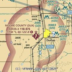
| Sectional chart |
|---|
|
CAUTION: Diagram may not be current

| Airport distance calculator |
|---|
|
|
| Sunrise and sunset |
|---|
|
Times for 31-Jul-2026
| | Local
(UTC-5) | | Zulu
(UTC) |
|---|
| Morning civil twilight | | 06:28 | | 11:28 |
| Sunrise | | 06:56 | | 11:56 |
| Sunset | | 20:53 | | 01:53 |
| Evening civil twilight | | 21:21 | | 02:21 |
|
| Current date and time |
|---|
| Zulu (UTC) | 01-Aug-2026 03:39:22 |
|---|
| Local (UTC-5) | 31-Jul-2026 22:39:22 |
|---|
|
| METAR |
|---|
| KDUX | 010315Z AUTO 30003KT 10SM FEW090 SCT120 26/14 A3018 RMK AO2 LTG DSNT SE AND S
|
|
| TAF |
|---|
KDHT
28nm W | 311724Z 3118/0118 04017G27KT P6SM FEW250 FM312100 06014KT P6SM SCT110 FM010200 35009KT P6SM BKN100 FM010600 01005KT P6SM SCT250
|
|
| NOTAMs |
|---|
NOTAMs are issued by the DoD/FAA and will open in a separate window not controlled by AirNav.
|
|


