FAA INFORMATION EFFECTIVE 25 DECEMBER 2025
Location
| FAA Identifier: | ELP |
| Lat/Long: | 31-48-26.4000N 106-22-34.9000W
31-48.440000N 106-22.581667W
31.8073333,-106.3763611
(estimated) |
| Elevation: | 3961.6 ft. / 1207.5 m (surveyed) |
| Variation: | 08E (2015) |
| From city: | 4 miles NE of EL PASO, TX |
| Time zone: | UTC -7 (UTC -6 during Daylight Saving Time) |
| Zip code: | 79925 |
Airport Operations
| Airport use: | Open to the public |
| Activation date: | 11/1938 |
| Control tower: | yes |
| ARTCC: | ALBUQUERQUE CENTER |
| FSS: | ALBUQUERQUE FLIGHT SERVICE STATION |
| NOTAMs facility: | ELP (NOTAM-D service available) |
| Attendance: | CONTINUOUS |
| Pattern altitude: | TPA: 1038 FT AGL SMALL ACFT, 1542 FT AGL TURBOJET, 2042 FT AGL OVERHEAD APCH. |
| Wind indicator: | lighted |
| Segmented circle: | no |
| Lights: | SS-SR |
| Beacon: | white-green (lighted land airport)
Operates sunset to sunrise. |
| Fire and rescue: | ARFF index C |
| International operations: | international airport of entry |
Airport Communications
| UNICOM: | 122.95 |
| WX ASOS: | PHONE 915-774-9497 |
| EL PASO GROUND: | 121.9 348.6 |
| EL PASO TOWER: | 118.3 239.275 |
| EL PASO APPROACH: | 119.15 ;SOUTH-V16 124.25 ;NORTH-V16 298.85 ;NORTH-V16 353.5 ;SOUTH-V16 |
| EL PASO DEPARTURE: | 119.15 263.0 |
| CLEARANCE DELIVERY: | 125.0 379.1 |
| PRE-TAXI CLEARANCE: | 125.0 |
| ATKNN DP: | 119.15 263.0 |
| CLASS C: | 119.15 ;SOUTH-V16 119.15 124.25 ;NORTH-V16 298.85 ;NORTH-V16 353.5 ;SOUTH-V16 |
| D-ATIS: | 120.0 254.3 |
| EMERG: | 121.5 243.0 |
| IC: | 124.25 ;NORTH-V16 298.85 ;NORTH-V16 |
| JCOXX DP: | 119.15 263.0 |
| LATVE DP: | 119.15 263.0 |
| NEVUE DP: | 119.15 263.0 |
| TDOWN DP: | 119.15 263.0 |
| WX AWOS-3PT at DNA (17 nm W): | 124.175 (575-589-2643) |
Nearby radio navigation aids
| VOR radial/distance | | VOR name | | Freq | | Var |
|---|
| ELPr252/4.8 | | EL PASO VORTAC | | 115.20 | | 12E |
| EWMr199/10.2 | | NEWMAN VORTAC | | 112.40 | | 12E |
Airport Services
| Fuel available: | 100LL JET-A1+
100LL:FOR FUEL AT MIL RAMP CTC ATLANTIC AVIATION 122.95 OR 915-779-2831. |
| Parking: | hangars and tiedowns |
| Airframe service: | MAJOR |
| Powerplant service: | MAJOR |
| Bottled oxygen: | LOW |
| Bulk oxygen: | LOW |
Runway Information
Runway 4/22
| Dimensions: | 12020 x 150 ft. / 3664 x 46 m |
| Surface: | asphalt/concrete/grooved, in fair condition
RWY 4/22 206 FEET CONC, 10,814 FEET ASPH, 1,000 FEET CONC. |
| Weight bearing capacity: | | Single wheel: | 100.0 | | Double wheel: | 180.0 | | Double tandem: | 350.0 |
|
| Runway edge lights: | high intensity |
| RUNWAY 4 | | RUNWAY 22 |
| Latitude: | 31-48.092675N | | 31-49.366853N |
| Longitude: | 106-23.991042W | | 106-22.213035W |
| Elevation: | 3916.9 ft. | | 3949.5 ft. |
| Traffic pattern: | left | | right |
| Runway heading: | 042 magnetic, 050 true | | 222 magnetic, 230 true |
| Declared distances: | TORA:12020 TODA:12020 ASDA:12020 LDA:12020 | | TORA:12020 TODA:12020 ASDA:12020 LDA:12020 |
| Markings: | precision, in good condition | | precision, in good condition |
| Visual slope indicator: | 4-light PAPI on left (3.00 degrees glide path) | | 4-light PAPI on right (3.00 degrees glide path) |
| RVR equipment: | touchdown, rollout | | touchdown, rollout |
| Approach lights: | | | MALSR: 1,400 foot medium intensity approach lighting system with runway alignment indicator lights |
| Runway end identifier lights: | yes | | |
| Touchdown point: | yes, no lights | | yes, no lights |
| Instrument approach: | LOC/DME | | ILS/DME |
Runway 8R/26L
| Dimensions: | 9025 x 150 ft. / 2751 x 46 m |
| Surface: | asphalt/concrete/grooved, in fair condition
RWY 08R/26L 7,780 FEET ASPH, 1,247 FEET CONC. |
| Weight bearing capacity: | | Single wheel: | 100.0 | | Double wheel: | 180.0 | | Double tandem: | 350.0 |
|
| Runway edge lights: | high intensity |
| RUNWAY 8R | | RUNWAY 26L |
| Latitude: | 31-48.122515N | | 31-48.036583N |
| Longitude: | 106-23.318888W | | 106-21.579175W |
| Elevation: | 3927.1 ft. | | 3961.6 ft. |
| Traffic pattern: | right | | left |
| Runway heading: | 085 magnetic, 093 true | | 265 magnetic, 273 true |
| Declared distances: | TORA:9025 TODA:9025 ASDA:9025 LDA:9025 | | TORA:9025 TODA:9025 ASDA:9025 LDA:9025 |
| Markings: | nonprecision, in good condition | | nonprecision, in good condition |
| Visual slope indicator: | 4-light PAPI on left (3.00 degrees glide path) | | 4-light PAPI on right (3.00 degrees glide path) |
| Approach lights: | | | MALSR: 1,400 foot medium intensity approach lighting system with runway alignment indicator lights |
| Runway end identifier lights: | yes | | |
| Touchdown point: | yes, no lights | | yes, no lights |
Runway 8L/26R
| Dimensions: | 5499 x 75 ft. / 1676 x 23 m |
| Surface: | concrete/grooved, in good condition |
| Weight bearing capacity: | | Single wheel: | 60.0 | | Double wheel: | 180.0 |
|
| Runway edge lights: | medium intensity |
| Operational restrictions: | RWY 08L/26R NOT AVBL FOR PART 121/PART 380 OPS WITH SKED PAX CARRYING OPS MORE THAN 9 PAX SEATS AND NON-SKED PAX CARRYING OPS MORE THAN 30 PAX SEATS. |
| RUNWAY 8L | | RUNWAY 26R |
| Latitude: | 31-48.422210N | | 31-48.369748N |
| Longitude: | 106-22.189660W | | 106-21.129613W |
| Elevation: | 3952.6 ft. | | 3949.2 ft. |
| Traffic pattern: | left | | right |
| Runway heading: | 085 magnetic, 093 true | | 265 magnetic, 273 true |
| Declared distances: | TORA:5499 TODA:5499 ASDA:5499 LDA:5499 | | TORA:5499 TODA:5499 ASDA:5499 LDA:5499 |
| Markings: | basic, in good condition | | nonprecision, in good condition |
| Touchdown point: | yes, no lights | | yes, no lights |
Airport Ownership and Management from official FAA records
| Ownership: | Publicly-owned |
| Owner: | CITY OF EL PASO
300 N. CAMPBELL
EL PASO, TX 79901
Phone (915) 212-0000 |
| Manager: | TONY NEVAREZ
6701 CONVAIR RD
EL PASO, TX 79925
Phone 915-212-0333 |
Additional Remarks
| A39-08L/26R | PCR VALUE: 100/R/C/W/T |
| A39-04/22 | PCR VALUE: 680/F/B/X/T |
| A39-08R/26L | PCR VALUE: 520/F/B/X/T |
| - | 24 HR PPR CLASS A EXPLOSIVES CTC 915-212-0333. |
| - | HOLDING POSITION MARKINGS FOR RUNWAY 8R APPROACH AND RUNWAY 4/22 ARE IN CLOSE PROXIMITY TO THE TERMINAL APRON; REVIEW AIRPORT DIAGRAM PRIOR TO PUSHBACK FROM THE GATE. |
| - | MILITARY USERS SHOULD REVIEW NOISE ABATEMENT PROCEDURES LISTED FOR BIGGS AAF. |
| - | NOISE ABATEMENT PROCEDURES IN EFFECT, CTC ATCT FOR DETAILS. |
| - | ENGINE POWER IS RSTRD TO IDLE POWER ON ONE ENGINE AT A TIME FOR MAX 5 MIN ON ANY TERMINAL OR PARKING APRONS, CROSS-BLEED STARTS OR OTHER PRE DEP ACTIVITY ON MOVEMENT AREAS ONLY, MAINT OR OTR RQRMT NEEDING LONGER OR HIGHER POWER CTC TWR FOR DIRECTIONS TO DESIGNATED RUNUP AREAS. |
| - | COMPASS ROSE CLSD PERMLY. |
| - | CTN: BIGGS AAF 2NM NW RWY 22 CAN BE MISTAKEN FOR ELP RWY 22. |
| - | NORTH BOUND TFC PROHIBITED ON TWY F SOUTH OF APCH END RWY 08R. |
| - | TWY A SOUTH OF RWY 4; TWY J NE OF TWY K1; TWY J1 AND TWY J9 NOT VISIBLE FM ATCT. |
Instrument Procedures
NOTE: All procedures below are presented as PDF files. If you need a reader for these files, you should download the free Adobe Reader.NOT FOR NAVIGATION. Please procure official charts for flight.
FAA instrument procedures published for use from 25 December 2025 at 0901z to 22 January 2026 at 0900z.
STARs - Standard Terminal Arrivals |
|---|
| BEAHR THREE (RNAV) | |
download (141KB) |
| HSKNS ONE (RNAV) | |
download (154KB) |
| MOLLY FIVE (RNAV) | |
download (215KB) |
| SAMMR THREE (RNAV) | |
download (176KB) |
| WAZKO ONE (RNAV) | |
2 pages:
[1] [2] (277KB) |
IAPs - Instrument Approach Procedures |
|---|
| ILS OR LOC RWY 22 | |
download (311KB) |
| RNAV (RNP) X RWY 08R | |
download (249KB) |
| RNAV (RNP) Y RWY 04 | |
download (216KB) |
| RNAV (RNP) Y RWY 08R | |
download (213KB) |
| RNAV (RNP) Z RWY 04 | |
download (214KB) |
| RNAV (RNP) Z RWY 22 | |
download (261KB) |
| RNAV (RNP) Z RWY 26L | |
download (256KB) |
| RNAV (GPS) RWY 26R | |
download (232KB) |
| RNAV (GPS) X RWY 04 | |
download (220KB) |
| RNAV (GPS) Y RWY 22 | |
download (274KB) |
| RNAV (GPS) Y RWY 26L | |
download (243KB) |
| LOC/DME RWY 04 | |
download (243KB) |
| VOR RWY 26L | |
download (302KB) |
| HI-VOR OR TACAN RWY 26L | |
download (203KB) |
| Radar Approach Procedures available | |
download (165KB) |
| NOTE: Special Alternate Minimums apply | |
download (125KB) |
Departure Procedures |
|---|
| ATKNN FIVE (RNAV) | |
2 pages:
[1] [2] (372KB) |
| JCOXX TWO (RNAV) | |
download (203KB) |
| LATVE THREE (RNAV) | |
2 pages:
[1] [2] (318KB) |
| NEVUE THREE (RNAV) | |
2 pages:
[1] [2] (293KB) |
| TDOWN THREE (RNAV) | |
2 pages:
[1] [2] (305KB) |
| NOTE: Special Take-Off Minimums/Departure Procedures apply | |
download (144KB) |
Other nearby airports with instrument procedures:
KBIF - Biggs Army Airfield (Fort Bliss) (3 nm N)
KDNA - Dona Ana County International Jetport Airport (17 nm W)
KLRU - Las Cruces International Airport (40 nm NW)
KHMN - Holloman Air Force Base (64 nm N)
KALM - Alamogordo-White Sands Regional Airport (65 nm N)
|
|

Road maps at:
MapQuest
Bing
Google
| Aerial photo |
|---|
WARNING: Photo may not be current or correct
 Phtoo by Ted Louis Green
Taken in July 2008
Phtoo by Ted Louis Green
Taken in July 2008
Do you have a better or more recent aerial photo of El Paso International Airport that you would like to share? If so, please send us your photo.
|
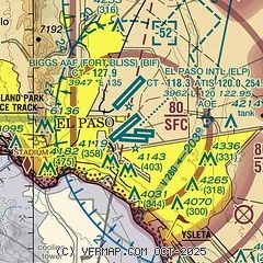
| Sectional chart |
|---|
|
CAUTION: Diagram may not be current
 Download PDF
of official airport diagram from the FAA
| Airport distance calculator |
|---|
|
|
| Sunrise and sunset |
|---|
|
Times for 07-Jan-2026
| | Local
(UTC-7) | | Zulu
(UTC) |
|---|
| Morning civil twilight | | 06:41 | | 13:41 |
| Sunrise | | 07:08 | | 14:08 |
| Sunset | | 17:16 | | 00:16 |
| Evening civil twilight | | 17:43 | | 00:43 |
|
| Current date and time |
|---|
| Zulu (UTC) | 07-Jan-2026 16:41:14 |
|---|
| Local (UTC-7) | 07-Jan-2026 09:41:14 |
|---|
|
| METAR |
|---|
| KELP | 071551Z 17003KT 10SM FEW110 SCT160 BKN200 BKN250 11/00 A3001 RMK AO2 SLP127 VIRGA DSNT SE-S T01060000
|
KBIF
3nm N | 071555Z AUTO 00000KT 10SM FEW150 FEW220 09/M00 A3001 RMK AO2 SLP138 T00941005 $
|
MMCS
12nm S | 071540Z 12003KT 10SM SCT090 BKN140 OVC250 09/00 A3005 RMK 8/077
|
KDNA
17nm W | 071615Z AUTO 00000KT 10SM CLR 10/M01 A3003 RMK AO2
|
|
| TAF |
|---|
| KELP | 071122Z 0712/0812 VRB05KT P6SM SCT110 BKN140 BKN250 FM072000 27008KT P6SM SCT070 BKN120 PROB30 0800/0806 -SHRA SCT040 OVC080 FM080600 23015G25KT P6SM BKN080
|
KBIF
3nm N | 071200Z 0712/0818 VRB06KT 9999 BKN150 OVC200 621202 510008 QNH2983INS BECMG 0715/0716 VRB06KT 9999 SCT190 BKN200 510008 QNH3001INS BECMG 0723/0800 28012KT -RA 9000 BKN060 OVC070 520009 520905 QNH2985INS BECMG 0801/0802 VRB06KT -RA 9000 BKN050 OVC070 650409 651301 520009 520905 QNH2988INS BECMG 0804/0805 19010G15KT -RA 9000 OVC040 650409 651301 520009 520905 QNH2985INS BECMG 0807/0808 26015G25KT -RA 9000 OVC040 640808 520009 520905 QNH2983INS BECMG 0809/0810 26015G25KT 9999 BKN040 OVC060 520009 5
|
MMCS
12nm S | 070535Z 0706/0806 00000KT P6SM SCT200 FM071200 15004KT P6SM SCT100 SCT200 FM071800 20008KT P6SM SCT030 SCT080 BKN200 FM072000 24010KT P6SM SCT030CB BKN080 OVC200 TEMPO 0802/0806 4SM RA BKN015CB OVC080
|
|
| NOTAMs |
|---|
NOTAMs are issued by the DoD/FAA and will open in a separate window not controlled by AirNav.
|
|


