FAA INFORMATION EFFECTIVE 19 MARCH 2026
Location
| FAA Identifier: | ENV |
| Lat/Long: | 40-43-07.4110N 114-01-43.2250W
40-43.123517N 114-01.720417W
40.7187253,-114.0286736
(estimated) |
| Elevation: | 4236.7 ft. / 1291.3 m (surveyed) |
| Variation: | 12E (2015) |
| From city: | 1 mile SE of WENDOVER, UT |
| Time zone: | UTC -6 (UTC -7 during Standard Time) |
| Zip code: | 84083 |
Airport Operations
| Airport use: | Open to the public |
| Activation date: | 02/1973 |
| Control tower: | no |
| ARTCC: | SALT LAKE CITY CENTER |
| FSS: | CEDAR CITY FLIGHT SERVICE STATION |
| NOTAMs facility: | ENV (NOTAM-D service available) |
| Attendance: | 0800-1800 |
| Wind indicator: | yes |
| Segmented circle: | yes |
| Lights: | ACTVT REIL RWY 08, 12, 26, 30; PAPI RWY 08, 26, 30; MIRL RWY 08/26 & 12/30 - CTAF. |
| Beacon: | white-green (lighted land airport)
Operates sunset to sunrise. |
| Fire and rescue: | ARFF index B |
| Airline operations: | 24 HR PPR FOR ACFT OPNS WITH MORE THAN 30 PAX CALL AMGR 775-778-1891 OR 801-520-1613. WHEN REQD ARPT WILL MNTN ARFF INDEX B. |
Airport Communications
| CTAF/UNICOM: | 122.8 |
| WX AWOS-3PT: | 120.55 (435-665-2521) |
- COMMUNICATIONS PRVDD BY CEDAR CITY RADIO ON FREQ 122.1R 112.3T (BONNEVILLE RCO).
- APCH/DEP CTL SVC PRVDD BY SALT LAKE ARTCC (ZLC) ON 128.55/269.175 GRASSY MOUNTAIN RCAG).
Nearby radio navigation aids
| VOR radial/distance | | VOR name | | Freq | | Var |
|---|
| BVLr256/12.3 | | BONNEVILLE VORTAC | | 112.30 | | 12E |
| LCUr175/39.6 | | LUCIN VORTAC | | 113.60 | | 17E |
Airport Services
| Fuel available: | 100 JET-A |
| Parking: | hangars |
| Airframe service: | MINOR |
| Powerplant service: | MINOR |
Runway Information
Runway 8/26
| Dimensions: | 10002 x 150 ft. / 3049 x 46 m |
| Surface: | asphalt/grooved, in good condition |
| Weight bearing capacity: | | Single wheel: | 75.0 | | Double wheel: | 140.0 | | Double tandem: | 208.0 |
|
| Runway edge lights: | medium intensity |
| RUNWAY 8 | | RUNWAY 26 |
| Latitude: | 40-43.136435N | | 40-43.137240N |
| Longitude: | 114-02.605480W | | 114-00.441043W |
| Elevation: | 4229.7 ft. | | 4226.4 ft. |
| Traffic pattern: | right | | left |
| Runway heading: | 078 magnetic, 090 true | | 258 magnetic, 270 true |
| Declared distances: | TORA:10002 TODA:10002 ASDA:10002 LDA:10002 | | TORA:10002 TODA:10002 ASDA:10002 LDA:10002 |
| Markings: | precision, in good condition | | precision, in good condition |
| Visual slope indicator: | 4-light PAPI on left (3.00 degrees glide path) | | 4-light PAPI on left (3.00 degrees glide path) |
| Runway end identifier lights: | yes | | yes |
| Touchdown point: | yes, no lights | | yes, no lights |
Runway 12/30
| Dimensions: | 8002 x 100 ft. / 2439 x 30 m |
| Surface: | asphalt/grooved, in fair condition |
| Weight bearing capacity: | | Single wheel: | 75.0 | | Double wheel: | 140.0 | | Double tandem: | 180.0 |
|
| Runway edge lights: | medium intensity |
| RUNWAY 12 | | RUNWAY 30 |
| Latitude: | 40-43.572248N | | 40-42.641192N |
| Longitude: | 114-02.579503W | | 114-01.354318W |
| Elevation: | 4236.7 ft. | | 4224.3 ft. |
| Traffic pattern: | right | | left |
| Runway heading: | 123 magnetic, 135 true | | 303 magnetic, 315 true |
| Declared distances: | TORA:8002 TODA:8002 ASDA:8002 LDA:8002 | | TORA:8002 TODA:8002 ASDA:8002 LDA:8002 |
| Markings: | nonprecision, in good condition | | nonprecision, in good condition |
| Visual slope indicator: | | | 4-light PAPI on left (3.00 degrees glide path) |
| Runway end identifier lights: | yes | | yes |
| Touchdown point: | yes, no lights | | yes, no lights |
Airport Ownership and Management from official FAA records
| Ownership: | Publicly-owned |
| Owner: | TOOELE COUNTY
P.O. BOX 159
WENDOVER, UT 84083
Phone 435-843-3360 |
| Manager: | LISA DUNN
P.O. BOX 159
WENDOVER, UT 84083
Phone 435-843-3360 |
Additional Remarks
| A39-12/30 | PCR VALUE: 560/F/D/X/T |
| A39-08/26 | PCR VALUE: 490/F/D/X/T |
| - | COLD TEMPERATURE AIRPORT. ALTITUDE CORRECTION REQUIRED AT OR BELOW -12C. |
Instrument Procedures
NOTE: All procedures below are presented as PDF files. If you need a reader for these files, you should download the free Adobe Reader.NOT FOR NAVIGATION. Please procure official charts for flight.
FAA instrument procedures published for use from 19 March 2026 at 0901Z to 16 April 2026 at 0900Z.
IAPs - Instrument Approach Procedures |
|---|
| RNAV (GPS) RWY 08 | |
download (296KB) |
| RNAV (GPS) RWY 26 | |
download (203KB) |
| RNAV (GPS)-A | |
download (281KB) |
| RNAV (GPS)-C | |
download (294KB) |
| VOR/DME-B | |
download (425KB) |
| VOR/DME OR TACAN RWY 26 | |
download (225KB) |
| NOTE: Special Alternate Minimums apply | |
download (34KB) |
Departure Procedures |
|---|
| WENDOVER ONE (RNAV) | |
download (164KB) |
| NOTE: Special Take-Off Minimums/Departure Procedures apply | |
download (157KB) |
Other nearby airports with instrument procedures:
KDPG - Michael Army Airfield (Dugway Proving Ground) (59 nm SE)
KTVY - Bolinder Field/Tooele Valley Airport (77 nm E)
KEKO - Elko Regional Airport (80 nm W)
KSVR - South Valley Regional Airport (93 nm E)
KELY - Ely Airport/Yelland Field (93 nm SW)
|
|

Road maps at:
MapQuest
Bing
Google
| Aerial photo |
|---|
WARNING: Photo may not be current or correct
 Photo courtesy of AirNav, LLC
Photo taken 15-Feb-2014
looking north.
Photo courtesy of AirNav, LLC
Photo taken 15-Feb-2014
looking north.
Do you have a better or more recent aerial photo of Wendover Airport that you would like to share? If so, please send us your photo.
|
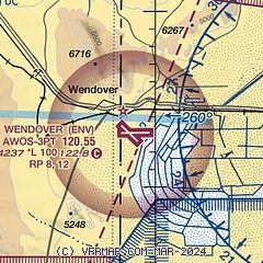
| Sectional chart |
|---|
|
| Airport distance calculator |
|---|
|
|
| Sunrise and sunset |
|---|
|
Times for 02-Apr-2026
| | Local
(UTC-6) | | Zulu
(UTC) |
|---|
| Morning civil twilight | | 06:51 | | 12:51 |
| Sunrise | | 07:19 | | 13:19 |
| Sunset | | 20:01 | | 02:01 |
| Evening civil twilight | | 20:28 | | 02:28 |
|
| Current date and time |
|---|
| Zulu (UTC) | 02-Apr-2026 07:26:51 |
|---|
| Local (UTC-6) | 02-Apr-2026 01:26:51 |
|---|
|
| METAR |
|---|
| KENV | 020656Z AUTO 18013KT 10SM FEW060 09/04 A2969 RMK AO2 SLP039 T00940039
|
|
| TAF |
|---|
| KENV | 020520Z 0206/0306 22005KT P6SM SCT050 BKN090 FM021000 28015G25KT P6SM VCSH SCT050 OVC090 FM021500 31025G35KT P6SM -SHSN SCT035 OVC060 FM021700 30025G35KT P6SM VCSH BKN070 FM030500 30015G25KT P6SM SCT070
|
|
| NOTAMs |
|---|
NOTAMs are issued by the DoD/FAA and will open in a separate window not controlled by AirNav.
|
|

