FAA INFORMATION EFFECTIVE 25 DECEMBER 2025
Location
| FAA Identifier: | GLD |
| Lat/Long: | 39-22-14.6670N 101-41-55.4420W
39-22.244450N 101-41.924033W
39.3707408,-101.6987339
(estimated) |
| Elevation: | 3657.6 ft. / 1114.8 m (surveyed) |
| Variation: | 09E (1985) |
| From city: | 2 miles N of GOODLAND, KS |
| Time zone: | UTC -7 (UTC -6 during Daylight Saving Time) |
| Zip code: | 67735 |
Airport Operations
| Airport use: | Open to the public |
| Activation date: | 04/1940 |
| Control tower: | no |
| ARTCC: | DENVER CENTER |
| FSS: | WICHITA FLIGHT SERVICE STATION |
| NOTAMs facility: | GLD (NOTAM-D service available) |
| Attendance: | DAYLIGHT HOURS
FOR SVC CALL 785-890-7531 (DAY) OR 785-443-1328 (NIGHT). |
| Wind indicator: | lighted |
| Segmented circle: | no |
| Lights: | ACTVT MALSR RWY 30; REIL RWY 12; PAPI RWY 05 & 23; MIRL RWY 05/23 & 12/30 - CTAF. |
| Beacon: | white-green (lighted land airport)
Operates sunset to sunrise. |
Airport Communications
| CTAF/UNICOM: | 122.8 |
| WX ASOS: | 121.025 (785-576-2383) |
- APCH/DEP CTL SVC PRVDD BY DENVER ARTCC (ZDV) ON FREQS 132.7/226.675 (GOODLAND RCAG).
Nearby radio navigation aids
| VOR radial/distance | | VOR name | | Freq | | Var |
|---|
| GLDr184/1.1 | | GOODLAND VORTAC | | 115.10 | | 12E |
| NDB name | | Hdg/Dist | | Freq | | Var | | ID |
|---|
| KIT CARSON | | 069/28.2 | | 209 | | 06E | | ITR | .. - .-. |
Airport Services
| Fuel available: | 100LL JET-A+ |
| Parking: | hangars and tiedowns |
| Airframe service: | MAJOR |
| Powerplant service: | MAJOR |
| Bottled oxygen: | NONE |
| Bulk oxygen: | LOW |
Runway Information
Runway 12/30
| Dimensions: | 5499 x 100 ft. / 1676 x 30 m |
| Surface: | concrete, in good condition |
| Weight bearing capacity: | | PCN 11 /R/C/X/U | | Single wheel: | 30.0 | | Double wheel: | 48.0 |
|
| Runway edge lights: | medium intensity |
| RUNWAY 12 | | RUNWAY 30 |
| Latitude: | 39-22.483338N | | 39-21.850040N |
| Longitude: | 101-42.304725W | | 101-41.470565W |
| Elevation: | 3645.7 ft. | | 3653.4 ft. |
| Traffic pattern: | left | | left |
| Runway heading: | 125 magnetic, 134 true | | 305 magnetic, 314 true |
| Markings: | precision, in good condition | | precision, in good condition |
| Approach lights: | | | MALSR: 1,400 foot medium intensity approach lighting system with runway alignment indicator lights |
| Runway end identifier lights: | yes | | |
| Touchdown point: | yes, no lights | | yes, no lights |
| Instrument approach: | | | ILS/DME |
| Obstructions: | 30 ft. bldg, 720 ft. from runway, 525 ft. right of centerline, 17:1 slope to clear | | none |
Runway 5/23
| Dimensions: | 4001 x 75 ft. / 1220 x 23 m |
| Surface: | concrete, in excellent condition |
| Weight bearing capacity: | | PCN 5 /F/C/Y/U | | Single wheel: | 12.5 |
|
| Runway edge lights: | medium intensity |
| RUNWAY 5 | | RUNWAY 23 |
| Latitude: | 39-22.111070N | | 39-22.409643N |
| Longitude: | 101-42.309950W | | 101-41.553095W |
| Elevation: | 3657.6 ft. | | 3634.7 ft. |
| Traffic pattern: | left | | left |
| Runway heading: | 054 magnetic, 063 true | | 234 magnetic, 243 true |
| Markings: | nonprecision, in fair condition | | nonprecision, in fair condition |
| Visual slope indicator: | 4-light PAPI on left (3.00 degrees glide path)
PAPI UNUSBL BYD 8 DEGS L OF CNTRLN. | | 4-light PAPI on left (3.00 degrees glide path) |
| Touchdown point: | yes, no lights | | yes, no lights |
| Obstructions: | 22 ft. road, 625 ft. from runway, 270 ft. left of centerline, 19:1 slope to clear | | none |
Runway 17/35
| Dimensions: | 1754 x 40 ft. / 535 x 12 m |
| Surface: | turf, in good condition |
| Runway edge markings: | 3 FT DIA YELLOW CONES MARK THLD. |
| RUNWAY 17 | | RUNWAY 35 |
| Latitude: | 39-22.596363N | | 39-22.307462N |
| Longitude: | 101-42.022303W | | 101-42.019997W |
| Elevation: | 3639.6 ft. | | 3643.2 ft. |
| Traffic pattern: | left | | left |
| Runway heading: | 171 magnetic, 180 true | | 351 magnetic, 360 true |
| Markings: | , in fair condition | | , in fair condition |
| Touchdown point: | yes, no lights | | yes, no lights |
| Obstructions: | 62 ft. pole, 378 ft. from runway, 6:1 slope to clear
UNMKD 30 FT PLINE, 1300 FT DSTC, ACRS APCH, 43:1. | | none |
Airport Ownership and Management from official FAA records
| Ownership: | Publicly-owned |
| Owner: | CITY OF GOODLAND
P. O. BOX 59
GOODLAND, KS 67735
Phone 785-890-4500 |
| Manager: | KENT BROWN
204 W. 11TH ST.
GOODLAND, KS 67735
Phone 785-890-4501
CITY/ARPT MGR. |
Additional Remarks
| A30A-30 | CALM WIND RWY. |
| A30A-23 | TURN-AROUND DOES NOT HAVE CLNC FOR HLDG. |
| - | TWY A2 ONLY AVBL FOR ACFT OVER 12500 LBS. |
| - | FOR CD CTC DENVER ARTCC ON FREQ. IF UNA, CTC FSS ON FREQ VIA RCO. IF UNA, CTC DENVER ARTCC AT 303-651-4257. |
Instrument Procedures
NOTE: All procedures below are presented as PDF files. If you need a reader for these files, you should download the free Adobe Reader.NOT FOR NAVIGATION. Please procure official charts for flight.
FAA instrument procedures published for use from 25 December 2025 at 0901z to 22 January 2026 at 0900z.
IAPs - Instrument Approach Procedures |
|---|
| ILS OR LOC RWY 30 **CHANGED** | |
download (291KB) |
| RNAV (GPS) RWY 12 **CHANGED** | |
download (227KB) |
| RNAV (GPS) RWY 23 **CHANGED** | |
download (240KB) |
| RNAV (GPS) RWY 30 **CHANGED** | |
download (235KB) |
| VOR RWY 30 **CHANGED** | |
download (195KB) |
| NOTE: Special Alternate Minimums apply | |
download (149KB) |
| NOTE: Special Take-Off Minimums/Departure Procedures apply | |
download (360KB) |
Other nearby airports with instrument procedures:
KSYF - Cheyenne County Municipal Airport (24 nm N)
KITR - Kit Carson County Airport (28 nm W)
KCBK - Shalz Field Airport (30 nm E)
KADT - Atwood-Rawlins County City-County Airport (41 nm NE)
KOEL - Oakley Municipal Airport (44 nm E)
|
|

Road maps at:
MapQuest
Bing
Google
| Aerial photo |
|---|
WARNING: Photo may not be current or correct
 Photo taken 31-Mar-2007
Do you have a better or more recent aerial photo of Renner Field/Goodland Municipal Airport that you would like to share? If so, please send us your photo.
|
| Sectional chart |
|---|
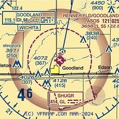
|
 Download PDF
of official airport diagram from the FAA
| Airport distance calculator |
|---|
|
|
| Sunrise and sunset |
|---|
|
Times for 11-Jan-2026
| | Local
(UTC-7) | | Zulu
(UTC) |
|---|
| Morning civil twilight | | 06:38 | | 13:38 |
| Sunrise | | 07:07 | | 14:07 |
| Sunset | | 16:42 | | 23:42 |
| Evening civil twilight | | 17:12 | | 00:12 |
|
| Current date and time |
|---|
| Zulu (UTC) | 12-Jan-2026 01:51:21 |
|---|
| Local (UTC-7) | 11-Jan-2026 18:51:21 |
|---|
|
| METAR |
|---|
| KGLD | 120053Z AUTO 27005KT 10SM CLR 02/M11 A3033 RMK AO2 SLP292 T00221106
|
|
| TAF |
|---|
| KGLD | 111733Z 1118/1218 27011KT P6SM SCT250 FM121700 31014KT P6SM SKC
|
|
| NOTAMs |
|---|
NOTAMs are issued by the DoD/FAA and will open in a separate window not controlled by AirNav.
|
|


