FAA INFORMATION EFFECTIVE 14 MAY 2026
Location
| FAA Identifier: | GON |
| Lat/Long: | 41-19-48.2000N 072-02-42.5000W
41-19.803333N 072-02.708333W
41.3300556,-72.0451389
(estimated) |
| Elevation: | 9.1 ft. / 2.8 m (surveyed) |
| Variation: | 14W (1980) |
| From city: | 3 miles SE of GROTON (NEW LONDON), CT |
| Time zone: | UTC -4 (UTC -5 during Standard Time) |
| Zip code: | 06340 |
Airport Operations
| Airport use: | Open to the public |
| Activation date: | 04/1940 |
| Control tower: | yes |
| ARTCC: | BOSTON CENTER |
| FSS: | BRIDGEPORT FLIGHT SERVICE STATION |
| NOTAMs facility: | GON (NOTAM-D service available) |
| Attendance: | 0600- 2100 |
| Pattern altitude: | 1000 FT LGT ACFT; 1500 FT ALL TURBINE PWRD ACFT. |
| Wind indicator: | lighted |
| Segmented circle: | yes |
| Lights: | WHEN ATCT CLSD, ACTVT MALSR RWY 05; HIRL RWYS 05/23 & 15/33 - CTAF. |
| Beacon: | white-green (lighted land airport)
Operates sunset to sunrise. |
| Landing fee: | yes, LDG FEE FOR BUS/CORPORATE & REVENUE PRODUCING ACFT. |
| Fire and rescue: | ARFF index A |
| Airline operations: | CLSD TO UNSKED ACR OPNS WITH MORE THAN 30 PSGR SEATS EXC 48 HR PPR, CALL 860-250-4701. |
| International operations: | customs landing rights airport
U.S. CUST SVC AVBL WITH 6 HR PPR CALL MON-FRI
0800-1600 ON 203-773-2040 (OR TOLL FREE IN THE U.S.
1-800-973-2867) & FM CANADA 407- 975-1740. CALL
BFR 1500 ON FRIDAY FOR WKEND OR HOL SVC REQS. |
Airport Communications
| CTAF: | 125.6 |
| ATIS: | 127.0 |
| WX ASOS: | 127.0 (860-449-8921) |
| GROTON GROUND: | 121.65 236.775 [0700-2200] |
| GROTON TOWER: | 125.6 236.775 [0700-2200] |
| PROVIDENCE APPROACH: | 125.75 |
| PROVIDENCE DEPARTURE: | 125.75 |
| CLEARANCE DELIVERY: | 121.65 119.85 ;WHEN TWR CLSD 2200-0000, 060 |
| EMERG: | 121.5 |
| NG OPS: | 126.2 304.6 |
| WX ASOS at WST (11 nm E): | 132.375 (401-596-9543) |
- APCH/DEP SVC PRVDD BY BOSTON ARTCC ON FREQS 124.85/307.9 (WOODSTOCK RCAG) WHEN PROVIDENCE APCH CTL CLSD.
Nearby radio navigation aids
| VOR radial/distance | | VOR name | | Freq | | Var |
|---|
| GON at field | | GROTON VOR/DME | | 110.85 | | 14W |
| ORWr203/13.7 | | NORWICH VOR/DME | | 110.00 | | 14W |
| SEYr310/23.3 | | SANDY POINT VOR/DME | | 117.80 | | 15W |
| HTOr039/27.5 | | HAMPTON VORTAC | | 113.60 | | 13W |
| MADr101/29.2 | | MADISON VOR/DME | | 110.40 | | 13W |
| HFDr143/29.3 | | HARTFORD VOR/DME | | 114.90 | | 13W |
| PVDr243/36.4 | | PROVIDENCE VOR/DME | | 115.60 | | 14W |
| PUTr208/38.6 | | PUTNAM VOR/DME | | 117.40 | | 14W |
Airport Services
| Fuel available: | 100LL JET-A |
| Parking: | tiedowns |
| Airframe service: | MAJOR |
| Powerplant service: | MAJOR |
| Bottled oxygen: | HIGH/LOW |
| Bulk oxygen: | HIGH/LOW |
Runway Information
Runway 5/23
| Dimensions: | 5000 x 150 ft. / 1524 x 46 m |
| Surface: | asphalt/grooved, in good condition |
| Weight bearing capacity: | | Single wheel: | 90.0 | | Double wheel: | 113.0 | | Double tandem: | 200.0 |
|
| Runway edge lights: | high intensity |
| Runway edge markings: | RWY NR NOT STD. |
| RUNWAY 5 | | RUNWAY 23 |
| Latitude: | 41-19.501935N | | 41-20.184793N |
| Longitude: | 072-02.881558W | | 072-02.271175W |
| Elevation: | 5.2 ft. | | 6.3 ft. |
| Traffic pattern: | left | | left |
| Runway heading: | 048 magnetic, 034 true | | 228 magnetic, 214 true |
| Declared distances: | TORA:5000 TODA:5000 ASDA:5000 LDA:5000 | | TORA:5000 TODA:5000 ASDA:5000 LDA:5000 |
| Markings: | precision, in good condition | | nonprecision, in good condition |
| Visual slope indicator: | 4-light PAPI on left (3.00 degrees glide path) | | 4-box VASI on left (3.00 degrees glide path) |
| RVR equipment: | touchdown | | rollout |
| Approach lights: | MALSR: 1,400 foot medium intensity approach lighting system with runway alignment indicator lights | | |
| Runway end identifier lights: | | | yes |
| Touchdown point: | yes, no lights | | yes, no lights |
| Instrument approach: | ILS/DME | | |
| Obstructions: | none | | 48 ft. tree, 1800 ft. from runway, 34:1 slope to clear |
Runway 15/33
| Dimensions: | 4000 x 96 ft. / 1219 x 29 m |
| Surface: | asphalt/grooved, in good condition |
| Weight bearing capacity: | | Single wheel: | 90.0 | | Double wheel: | 113.0 |
|
| Runway edge lights: | high intensity |
| RUNWAY 15 | | RUNWAY 33 |
| Latitude: | 41-19.986968N | | 41-19.520807N |
| Longitude: | 072-03.180853W | | 072-02.563563W |
| Elevation: | 8.7 ft. | | 5.8 ft. |
| Traffic pattern: | left | | left |
| Runway heading: | 149 magnetic, 135 true | | 329 magnetic, 315 true |
| Displaced threshold: | 307 ft. | | 205 ft.
TREES 34:1 TO DTHR. |
| Declared distances: | TORA:4000 TODA:4000 ASDA:3798 LDA:3491 | | TORA:4000 TODA:4000 ASDA:3871 LDA:3666 |
| Markings: | basic, in good condition | | nonprecision, in good condition |
| Visual slope indicator: | 4-light PAPI on right (4.00 degrees glide path) | | 4-light PAPI on left (3.75 degrees glide path) |
| Runway end identifier lights: | no | | yes |
| Touchdown point: | yes, no lights | | yes, no lights |
| Obstructions: | 12 ft. tree, lighted, 450 ft. from runway, 20:1 slope to clear
APCH RATIO 25:1 TO DTHR. | | 44 ft. trees, 1600 ft. from runway, 150 ft. right of centerline, 31:1 slope to clear |
Helipad H1
| Dimensions: | 45 x 45 ft. / 14 x 14 m |
| Surface: | asphalt |
| Latitude: | 41-19.849333N | | |
| Longitude: | 072-02.682333W | | |
| Elevation: | 9.0 ft. | | |
| Traffic pattern: | left | | left |
| Markings: | none | | |
Airport Ownership and Management from official FAA records
| Ownership: | Publicly-owned |
| Owner: | CONNECTICUT AIRPORT AUTHORITY
BRADLEY INTERNATIONAL AIRPORT, ADMIN OFFICES TERMINAL A 3RD FLOOR
WINDSOR LOCKS, CT 06096
Phone 860-292-2083 |
| Manager: | DAVID LUCAS
155 TOWER AVE
GROTON, CT 06340
Phone 860-841-9664 |
Additional Remarks
| A39-05/23 | PCR VALUE: 1750/F/A/X/T |
| A39-15/33 | PCR VALUE: 1750/F/A/X/T |
| E60-05 | ENGINEERED MATERIALS ARRESTING SYSTEM (EMAS) 130 FT LENGTH BY 162 FT WIDTH LCTD AT DER 05. |
| E60-23 | ENGINEERED MATERIALS ARRESTING SYSTEM (EMAS) 340 FT LENGTH BY 162 FT WIDTH LCTD AT DER 23. |
| - | NOISE ABATEMENT PROCS IN EFCT ARE AS FLWS: RWY 05: TURN LEFT HDG 020 TIL RCHG 1000 FT, THEN ON CRS; RWY 23: TURN LEFT HDG 210 TIL RCHG 1000 FT, THEN ON CRS; RWY 33: FLY RWY HDG TIL RCHG 1000 FT, THEN ON CRS. |
| - | NO TGL OPNS PMTD BTN 2200-0600. |
| - | TRML AERODROME FCST SVC AVBL. |
| - | FOR FUEL AFT HRS CALL BFR 2100 LCL DAY OF ARR 860-715-8800. |
| - | TSNT PILOTS AT GA RAMP EXIT & RE-ENTER ARPT VIA PILOT PEDESTRIAN GATE ADJ TO MAIN TERM WITH POSTED GATE LOCK COMBINATION. THIS GATE IS LGTD WITH ELECTRONIC SURVEILLANCE 24 HRS DLY. |
| - | ARNG: PPR FOR PARKING AT THE ARNG FACILITY, 860-441-2918, DSN 636-0918 0630-1600L WEEKDAYS. ACFT INBD TO ARNG RAMP CTC BLACKJACK OPS (304.6) 10 MIN PRIOR TO LANDING FOR STATUS OF PARKING. |
| - | ARNG: GENERAL SUPPORT FAC OPR 1130-2100Z++ MON-FRI EXC HOL. |
| - | CONDS NOT MNT FM 1800 LCL TO 0600 LCL, MON-FRI AND FM 1500 LCL TO 0700 LCL, SAT-SUN. |
| - | FOR CD WHEN APCH CLSD CTC BOSTON ARTCC AT 603-879-6859. |
| - | DEER, BIRDS & WATERFOWL ON & INVOF ARPT. |
| - | PRACTICE APCHS/FULL-STOP/TGLS PROHIBITED BY PURE JET ACFT & ACFT WEIGHING 12500 LBS & OVR EXC BY WRITTEN APVL FM THE CONNECTICUT ARPT AUTH. |
Instrument Procedures
NOTE: All procedures below are presented as PDF files. If you need a reader for these files, you should download the free Adobe Reader.NOT FOR NAVIGATION. Please procure official charts for flight.
FAA instrument procedures published for use from 14 May 2026 at 0901Z to 11 June 2026 at 0900Z.
STARs - Standard Terminal Arrivals |
|---|
| SARDI ONE (RNAV) | |
2 pages:
[1] [2] (476KB) |
IAPs - Instrument Approach Procedures |
|---|
| ILS OR LOC RWY 05 | |
download (307KB) |
| RNAV (GPS) RWY 05 | |
download (265KB) |
| RNAV (GPS) RWY 23 | |
download (235KB) |
| RNAV (GPS) RWY 33 | |
download (208KB) |
| VOR RWY 05 | |
download (285KB) |
| VOR RWY 23 | |
download (293KB) |
| NOTE: Special Alternate Minimums apply | |
download (152KB) |
| NOTE: Special Take-Off Minimums/Departure Procedures apply | |
download (510KB) |
Other nearby airports with instrument procedures:
0B8 - Elizabeth Field Airport (5 nm S)
KWST - Westerly State Airport (11 nm E)
KMTP - Montauk Airport (16 nm S)
KSNC - Chester Airport (21 nm W)
KBID - Block Island State Airport (23 nm SE)
|
|

Road maps at:
MapQuest
Bing
Google
| Aerial photo |
|---|
WARNING: Photo may not be current or correct
 Photo by David Newcomer
Photo taken 24-Feb-2020
from 8,000' altitude looking north.
Photo by David Newcomer
Photo taken 24-Feb-2020
from 8,000' altitude looking north.
Do you have a better or more recent aerial photo of Groton-New London Airport that you would like to share? If so, please send us your photo.
|
| Sectional chart |
|---|
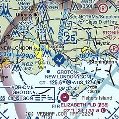
|
 Download PDF
of official airport diagram from the FAA
| Airport distance calculator |
|---|
|
|
| Sunrise and sunset |
|---|
|
Times for 01-Jun-2026
| | Local
(UTC-4) | | Zulu
(UTC) |
|---|
| Morning civil twilight | | 04:45 | | 08:45 |
| Sunrise | | 05:18 | | 09:18 |
| Sunset | | 20:14 | | 00:14 |
| Evening civil twilight | | 20:47 | | 00:47 |
|
| Current date and time |
|---|
| Zulu (UTC) | 02-Jun-2026 03:10:27 |
|---|
| Local (UTC-4) | 01-Jun-2026 23:10:27 |
|---|
|
| METAR |
|---|
| KGON | 020256Z AUTO 00000KT 10SM CLR 07/06 A3016 RMK AO2 SLP214 T00720061 50009
|
KWST
11nm E | 020253Z AUTO 00000KT 10SM CLR 08/07 A3016 RMK AO2 SLP212 T00780067 50008
|
KMTP
17nm S | 020254Z AUTO 00000KT 07/06 A3017 RMK AO1 SLP216 T00720061 50008
|
|
| TAF |
|---|
| KGON | 011936Z 0120/0218 04012G20KT P6SM SCT050 FM012200 09009KT P6SM SCT050 FM020200 VRB05KT P6SM SKC FM021500 24007KT P6SM SKC
|
|
| NOTAMs |
|---|
NOTAMs are issued by the DoD/FAA and will open in a separate window not controlled by AirNav.
|
|


