FAA INFORMATION EFFECTIVE 19 MARCH 2026
Location
| FAA Identifier: | GWW |
| Lat/Long: | 35-27-37.9990N 077-57-53.7390W
35-27.633317N 077-57.895650W
35.4605553,-77.9649275
(estimated) |
| Elevation: | 133.6 ft. / 40.7 m (surveyed) |
| Variation: | 08W (1990) |
| From city: | 3 miles N of GOLDSBORO, NC |
| Time zone: | UTC -4 (UTC -5 during Standard Time) |
| Zip code: | 27863 |
Airport Operations
| Airport use: | Open to the public |
| Activation date: | 11/1967 |
| Control tower: | no |
| ARTCC: | WASHINGTON CENTER |
| FSS: | RALEIGH FLIGHT SERVICE STATION |
| NOTAMs facility: | GWW (NOTAM-D service available) |
| Attendance: | MON-SAT 0800-1700, ALL SUN 1300-1700
UNATNDD FEDERAL HOL. |
| Wind indicator: | lighted |
| Segmented circle: | yes |
| Lights: | ACTVT REIL RWY 05 & 23; ODALS RWY 23; MIRL RWY 05/23 - CTAF. PAPIS RWY 05 & 23 OPERS CONS. |
| Beacon: | white-green (lighted land airport)
Operates sunset to sunrise. |
Airport Communications
| CTAF/UNICOM: | 122.975 |
| WX AWOS-3P: | 118.975 (919-731-4473) |
| SEYMOUR JOHNSON APPROACH: | 121.175 |
| SEYMOUR JOHNSON DEPARTURE: | 121.175 |
| WX AWOS-3PT at GSB (7 nm S): | 317.625 |
| WX AWOS-3P at W40 (15 nm S): | 120.075 (919-658-8067) |
| WX AWOS-3 at ISO (19 nm SE): | 132.75 (252-522-2712) |
- APCH/DEP SVC PRVDD BY WASHINGTON ARTCC (ZDC) ON 123.85/279.65 (NEW BERN RCAG) WHEN APCH CTL CLSD.
Nearby radio navigation aids
| VOR radial/distance | | VOR name | | Freq | | Var |
|---|
| ISOr290/20.6 | | KINSTON VORTAC | | 117.50 | | 05W |
| TYIr207/33.5 | | TAR RIVER VORTAC | | 117.80 | | 05W |
| NDB name | | Hdg/Dist | | Freq | | Var | | ID |
|---|
| ALWOOD | | 252/32.5 | | 230 | | 09W | | AQE | .- --.- . |
| CLINTON | | 043/35.0 | | 412 | | 09W | | CTZ | -.-. - --.. |
Airport Services
| Fuel available: | 100LL JET-A1+
100LL:24 HR SS FUEL AVAILABLE W CC. |
| Parking: | hangars and tiedowns |
| Airframe service: | MAJOR |
| Powerplant service: | MAJOR |
| Bottled oxygen: | NONE |
| Bulk oxygen: | NONE |
Runway Information
Runway 5/23
| Dimensions: | 5501 x 100 ft. / 1677 x 30 m |
| Surface: | asphalt, in excellent condition |
| Weight bearing capacity: | | PCN 19 /F/C/X/T | | Single wheel: | 51.0 | | Double wheel: | 71.0 |
|
| Runway edge lights: | medium intensity |
| RUNWAY 5 | | RUNWAY 23 |
| Latitude: | 35-27.279707N | | 35-27.986923N |
| Longitude: | 077-58.242470W | | 077-57.548773W |
| Elevation: | 132.7 ft. | | 132.7 ft. |
| Traffic pattern: | left | | left |
| Runway heading: | 047 magnetic, 039 true | | 227 magnetic, 219 true |
| Markings: | nonprecision, in good condition | | precision, in good condition |
| Visual slope indicator: | 4-light PAPI on left (3.00 degrees glide path) | | 4-light PAPI on left (3.00 degrees glide path) |
| Approach lights: | | | ODALS: omnidirectional approach lighting system |
| Runway end identifier lights: | yes | | yes |
| Touchdown point: | yes, no lights | | yes, no lights |
| Instrument approach: | | | ILS |
| Obstructions: | 93 ft. trees, 2163 ft. from runway, 393 ft. right of centerline, 21:1 slope to clear
HAS 9 FT BRUSH 135 FT FM THR OFFSET 327 LEFT OF CNTRLN. | | 52 ft. trees, 782 ft. from runway, 581 ft. right of centerline, 11:1 slope to clear |
Airport Ownership and Management from official FAA records
| Ownership: | Publicly-owned |
| Owner: | WAYNE COUNTY
240 AVIATION ROAD
PIKEVILLE, NC 27863
Phone 919-734-7630 |
| Manager: | GENE DAWSON
240 AVIATION ROAD
PIKEVILLE, NC 27863
Phone 919-734-7630 |
Additional Remarks
| - | ULTRALIGHT; GLIDER & PARACHUTE ACTIVITY PPR CALL 919-734-7630. |
| - | HELICOPTER OPS ON TWY LEADING TO T HANGERS. HELIPAD ON TWY WITH TRAFFIC CONES AND FLAGS. |
| - | BIRD ACTIVITY INVOF ARPT. |
| - | FOR EMERG SVC AFT HRS CALL 919-734-7630. |
| - | FOR CD CTC SEYMOUR JOHNSON APCH AT 919-722-4186. WHEN APCH CLSD, FOR CD CTC WASHINGTON ARTCC AT 703-771-3587. |
Instrument Procedures
NOTE: All procedures below are presented as PDF files. If you need a reader for these files, you should download the free Adobe Reader.NOT FOR NAVIGATION. Please procure official charts for flight.
FAA instrument procedures published for use from 19 March 2026 at 0901Z to 16 April 2026 at 0900Z.
IAPs - Instrument Approach Procedures |
|---|
| ILS OR LOC RWY 23 | |
download (273KB) |
| RNAV (GPS) RWY 05 | |
download (257KB) |
| RNAV (GPS) RWY 23 | |
download (281KB) |
| RNAV (GPS)-A | |
download (171KB) |
| NOTE: Special Alternate Minimums apply | |
download (167KB) |
| NOTE: Special Take-Off Minimums/Departure Procedures apply | |
download (355KB) |
Other nearby airports with instrument procedures:
KGSB - Seymour Johnson Air Force Base (7 nm S)
W40 - Mount Olive Municipal Airport (15 nm S)
W03 - Wilson Industrial Air Center Airport (19 nm N)
KISO - Kinston Regional Jetport at Stallings Field (19 nm SE)
KJNX - Johnston Regional Airport (21 nm W)
|
|

Road maps at:
MapQuest
Bing
Google
| Aerial photo |
|---|
WARNING: Photo may not be current or correct

Do you have a better or more recent aerial photo of Wayne Executive Jetport Airport that you would like to share? If so, please send us your photo.
|
| Sectional chart |
|---|
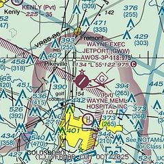
|
| Airport distance calculator |
|---|
|
|
| Sunrise and sunset |
|---|
|
Times for 30-Mar-2026
| | Local
(UTC-4) | | Zulu
(UTC) |
|---|
| Morning civil twilight | | 06:37 | | 10:37 |
| Sunrise | | 07:02 | | 11:02 |
| Sunset | | 19:30 | | 23:30 |
| Evening civil twilight | | 19:56 | | 23:56 |
|
| Current date and time |
|---|
| Zulu (UTC) | 31-Mar-2026 03:40:29 |
|---|
| Local (UTC-4) | 30-Mar-2026 23:40:29 |
|---|
|
| METAR |
|---|
| KGWW | 310315Z AUTO 21006KT 10SM CLR 17/11 A3034 RMK AO2 T01700110
|
KGSB
9nm S | 310155Z 20003KT 10SM CLR 18/12 A3034 RMK AO2A SLPNO RVRNO TSNO $
|
KISO
19nm SE | 310315Z AUTO 19007KT 10SM CLR 17/12 A3036 RMK AO2 T01670122
|
|
| TAF |
|---|
KGSB
9nm S | 300700Z 3007/3113 18006KT 9999 SCT250 QNH3041INS BECMG 3015/3016 20010G20KT 9999 SCT050 SCT250 QNH3043INS BECMG 3022/3023 18012KT 9999 FEW040 QNH3030INS TX22/3020Z TN08/3011Z LAST NO AMDS AFT 3007 NEXT 3009
|
KISO
19nm SE | 301723Z 3018/3118 22010G18KT P6SM BKN050 FM302300 19006KT P6SM FEW200 FM311300 22009KT P6SM FEW250 AMD LTD TO CLD VIS AND WIND
|
|
| NOTAMs |
|---|
NOTAMs are issued by the DoD/FAA and will open in a separate window not controlled by AirNav.
|
|

