FAA INFORMATION EFFECTIVE 25 DECEMBER 2025
Location
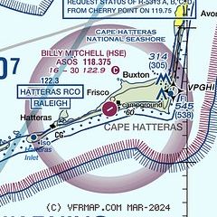
| FAA Identifier: | HSE |
| Lat/Long: | 35-13-58.1000N 075-37-04.1000W
35-13.968333N 075-37.068333W
35.2328056,-75.6178056
(estimated) |
| Elevation: | 16.3 ft. / 5.0 m (surveyed) |
| Variation: | 10W (1995) |
| From city: | 4 miles E of HATTERAS, NC |
| Time zone: | UTC -5 (UTC -4 during Daylight Saving Time) |
| Zip code: | 27920 |
Airport Operations
| Airport use: | Open to the public |
| Activation date: | 04/1960 |
| Control tower: | no |
| ARTCC: | WASHINGTON CENTER |
| FSS: | RALEIGH FLIGHT SERVICE STATION |
| NOTAMs facility: | HSE (NOTAM-D service available) |
| Attendance: | UNATNDD |
| Wind indicator: | lighted |
| Segmented circle: | no |
Airport Communications
| CTAF: | 122.9 |
| WX ASOS: | 118.375 (252-552-1005) |
| CHERRY POINT APPROACH: | 119.75 |
| CHERRY POINT DEPARTURE: | 119.75 |
- COMMUNICATIONS PRVDD BY RALEIGH RADIO ON FREQ 122.3 (HATTERAS RCO).
Airport Services
| Parking: | tiedowns |
| Airframe service: | NONE |
| Powerplant service: | NONE |
| Bottled oxygen: | NONE |
| Bulk oxygen: | NONE |
Runway Information
Runway 7/25
| Dimensions: | 3002 x 75 ft. / 915 x 23 m |
| Surface: | asphalt, in fair condition |
| Weight bearing capacity: | |
| RUNWAY 7 | | RUNWAY 25 |
| Latitude: | 35-13.831792N | | 35-14.103373N |
| Longitude: | 075-37.319745W | | 075-36.815510W |
| Elevation: | 8.6 ft. | | 16.1 ft. |
| Traffic pattern: | left | | left |
| Runway heading: | 067 magnetic, 057 true | | 247 magnetic, 237 true |
| Markings: | nonprecision, in good condition | | nonprecision, in good condition |
| Touchdown point: | yes, no lights | | yes, no lights |
| Obstructions: | 15 ft. brush, 413 ft. from runway, 232 ft. right of centerline, 14:1 slope to clear
5 FT SAND DUNES 0-200 FT FM THR 122 FT R OF CNTRLN, AND 10 FT SAND DUNES 0-200 FT FM THR 138 FT L OF CNTRLN. | | 24 ft. tree, 282 ft. from runway, 121 ft. right of centerline, 3:1 slope to clear
8 FT DUNE 52 FT FM THR 126 FT L OF CNTRLN; 15 FT WINDSOCK 72 FT FM THR 221 FT L OF CNTRLN; AND 26 FT TREES 0-100 FT FM THR 152 FT R OF CNTRLN. |
Airport Ownership and Management from official FAA records
| Ownership: | Publicly-owned |
| Owner: | NATIONAL PARK SERVICE
1401 NATIONAL PARK DR
MANTEO, NC 27954
Phone 252-475-9000
NCDOT DIVISION OF AVIATION COOPERATING AGENCY UNDER MOU; CTC NR 919-814-0550. |
| Manager: | MARK SEAMAN
1401 NATIONAL PARK DRIVE
MANTEO, NC 27954
Phone 252-475-9000
NTL PARKS SVC NR ANSWERED 7 DAYS A WEEK BTWN 0800 TO 1700. |
Additional Remarks
| - | +10-35 FT SAND DUNES AND SCRUB TREES BOTH SIDES OF RWY WITHIN ROFA. |
| - | ARPT CLSD 30 MIN AFTER SS TIL 30 MIN BEFORE SR. ALL NIGHTTIME OPNS PROHIBITED. |
| - | HIGH SPEED LOW LEVEL MIL OPNS IN VIC OF ARPT. |
| - | FLOCKS OF SEAGULLS ON & INVOF OF ARPT. |
| - | RWY 07/25 SAFETY AREA IS LOOSE SAND & DUNES - NOT SUITABLE FOR ACFT. |
| - | ADDITIONAL ACFT PARKING AVBL ON MID-FIELD APRON. |
| - | ARPT LCTD IN CAPE HATTERAS NTL SEASHORE. MNTN 2000 FT VER & HORIZONTAL DIST FM SEASHORE BEACHES. |
| - | FOR CD CTC CHERRY POINT APCH AT 252-466-5960. |
Instrument Procedures
NOTE: All procedures below are presented as PDF files. If you need a reader for these files, you should download the free Adobe Reader.NOT FOR NAVIGATION. Please procure official charts for flight.
FAA instrument procedures published for use from 25 December 2025 at 0901z to 22 January 2026 at 0900z.
IAPs - Instrument Approach Procedures |
|---|
| RNAV (GPS) RWY 07 | |
download (161KB) |
| RNAV (GPS) RWY 25 | |
download (180KB) |
| NOTE: Special Take-Off Minimums/Departure Procedures apply | |
download (141KB) |
Other nearby airports with instrument procedures:
W95 - Ocracoke Island Airport (19 nm SW)
7W6 - Hyde County Airport (26 nm NW)
KMQI - Dare County Regional Airport (41 nm N)
KFFA - First Flight Airport (47 nm N)
KMRH - Michael J Smith Field Airport (59 nm SW)
|
|

Road maps at:
MapQuest
Bing
Google
| Aerial photo |
|---|
WARNING: Photo may not be current or correct
 Photo by David Newcomer
Photo taken 16-Mar-2013
from 2,500' looking east.
Photo by David Newcomer
Photo taken 16-Mar-2013
from 2,500' looking east.
Do you have a better or more recent aerial photo of Billy Mitchell Airport that you would like to share? If so, please send us your photo.
|
| Sectional chart |
|---|
|
| Airport distance calculator |
|---|
|
|
| Sunrise and sunset |
|---|
|
Times for 15-Jan-2026
| | Local
(UTC-5) | | Zulu
(UTC) |
|---|
| Morning civil twilight | | 06:44 | | 11:44 |
| Sunrise | | 07:12 | | 12:12 |
| Sunset | | 17:12 | | 22:12 |
| Evening civil twilight | | 17:40 | | 22:40 |
|
| Current date and time |
|---|
| Zulu (UTC) | 15-Jan-2026 09:01:36 |
|---|
| Local (UTC-5) | 15-Jan-2026 04:01:36 |
|---|
|
| METAR |
|---|
| KHSE | 150851Z AUTO 25010G26KT 220V280 10SM CLR 10/06 A2957 RMK AO2 PK WND 25029/0822 SLP014 T01000056 57003
|
|
| NOTAMs |
|---|
NOTAMs are issued by the DoD/FAA and will open in a separate window not controlled by AirNav.
|
|

