FAA INFORMATION EFFECTIVE 14 MAY 2026
Location
| FAA Identifier: | I10 |
| Lat/Long: | 39-48-03.4950N 081-32-10.7680W
39-48.058250N 081-32.179467W
39.8009708,-81.5363244
(estimated) |
| Elevation: | 879.3 ft. / 268.0 m (surveyed) |
| Variation: | 07W (1990) |
| From city: | 3 miles N of CALDWELL, OH |
| Time zone: | UTC -4 (UTC -5 during Standard Time) |
| Zip code: | 43724 |
Airport Operations
| Airport use: | Open to the public |
| Activation date: | 11/1964 |
| Control tower: | no |
| ARTCC: | CLEVELAND CENTER |
| FSS: | CLEVELAND FLIGHT SERVICE STATION |
| NOTAMs facility: | CLE (NOTAM-D service available) |
| Attendance: | UNATNDD |
| Wind indicator: | lighted |
| Segmented circle: | no |
| Lights: | ACTVT MIRL RWY 05/23 - 122.7. PAPI RWY 23 OPR CONSLY. |
| Beacon: | white-green (lighted land airport)
ACTVT ABN - 122.7. |
Airport Communications
| CTAF/UNICOM: | 122.8 |
| WX AWOS-3 at CDI (11 nm N): | 118.525 (740-435-0086) |
| WX ASOS at ZZV (19 nm NW): | 127.0 (740-453-8139) |
- APCH/DEP SVC PRVDD BY INDIANAPOLIS ARTCC ON FREQS 124.45/323.275 (ZANESVILLE RCAG).
Nearby radio navigation aids
| VOR radial/distance | | VOR name | | Freq | | Var |
|---|
| JPUr344/22.8 | | PARKERSBURG VOR/DME | | 114.45 | | 03W |
| AIRr256/35.5 | | BELLAIRE VOR/DME | | 117.10 | | 07W |
| NDB name | | Hdg/Dist | | Freq | | Var | | ID |
|---|
| CADIZ | | 230/35.5 | | 239 | | 07W | | CFX | -.-. ..-. -..- |
Airport Services
Runway Information
Runway 5/23
| Dimensions: | 3811 x 65 ft. / 1162 x 20 m |
| Surface: | asphalt, in good condition |
| Weight bearing capacity: | |
| Runway edge lights: | medium intensity |
| RUNWAY 5 | | RUNWAY 23 |
| Latitude: | 39-47.819650N | | 39-48.296783N |
| Longitude: | 081-32.443517W | | 081-31.914683W |
| Elevation: | 876.0 ft. | | 879.3 ft. |
| Traffic pattern: | left | | left |
| Runway heading: | 048 magnetic, 041 true | | 228 magnetic, 221 true |
| Displaced threshold: | no | | 413 ft.
12:1 TO DTHR. |
| Markings: | basic, in fair condition | | basic, in fair condition |
| Visual slope indicator: | | | 2-light PAPI on left (3.50 degrees glide path) |
| Touchdown point: | yes, no lights | | yes, no lights |
| Obstructions: | 12 ft. trees, 212 ft. from runway, 55 ft. left of centerline, 1:1 slope to clear | | 55 ft. trees, 276 ft. from runway, 146 ft. right of centerline, 1:1 slope to clear
+55 FT TREES, 0-200 FT FM THR, 125 FT R. |
Airport Ownership and Management from official FAA records
| Ownership: | Publicly-owned |
| Owner: | NOBLE CO ARPT AUTH
48535 COLD WATER CREEK RD
CALDWELL, OH 43724-9436
Phone 740-732-7387 |
| Manager: | ED CROCK
301 LINCOLN DR
CALDWELL, OH 43724-9807
Phone 740-581-0557
OR 740-581-0162; 740-517-1554. |
Additional Remarks
| - | DEER, BIRDS, & OTR WILDLIFE ON & INVOF ARPT. |
| - | FOR CD CTC CLEVELAND ARTCC AT 440-774-0226/0490. |
Instrument Procedures
NOTE: All procedures below are presented as PDF files. If you need a reader for these files, you should download the free Adobe Reader.NOT FOR NAVIGATION. Please procure official charts for flight.
FAA instrument procedures published for use from 14 May 2026 at 0901Z to 11 June 2026 at 0900Z.
IAPs - Instrument Approach Procedures |
|---|
| RNAV (GPS) RWY 23 | |
download (175KB) |
| NOTE: Special Take-Off Minimums/Departure Procedures apply **CHANGED** | |
download (500KB) |
Other nearby airports with instrument procedures:
KCDI - Cambridge Municipal Airport (11 nm N)
KZZV - Zanesville Municipal Airport (19 nm NW)
6G5 - Barnesville/Bradfield Airport (20 nm NE)
4G5 - Monroe County Airport (20 nm E)
KPKB - Mid-Ohio Valley Regional Airport (28 nm S)
|
|

Road maps at:
MapQuest
Bing
Google
| Aerial photo |
|---|
WARNING: Photo may not be current or correct

Do you have a better or more recent aerial photo of Noble County Airport that you would like to share? If so, please send us your photo.
|
| Sectional chart |
|---|
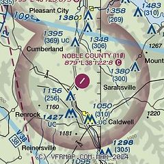
|
| Airport distance calculator |
|---|
|
|
| Sunrise and sunset |
|---|
|
Times for 05-Jun-2026
| | Local
(UTC-4) | | Zulu
(UTC) |
|---|
| Morning civil twilight | | 05:27 | | 09:27 |
| Sunrise | | 06:00 | | 10:00 |
| Sunset | | 20:50 | | 00:50 |
| Evening civil twilight | | 21:22 | | 01:22 |
|
| Current date and time |
|---|
| Zulu (UTC) | 05-Jun-2026 20:09:46 |
|---|
| Local (UTC-4) | 05-Jun-2026 16:09:46 |
|---|
|
| METAR |
|---|
KCDI
11nm N | 051955Z AUTO 23008G15KT 10SM BKN065 28/15 A3003 RMK AO2 T02820154
|
KZZV
19nm NW | 051953Z AUTO 21010G16KT 10SM FEW065 28/14 A3003 RMK AO2 SLP164 T02780144
|
|
| TAF |
|---|
KZZV
19nm NW | 051730Z 0518/0618 24012G17KT P6SM BKN050 FM060000 22005KT P6SM SCT100 BKN250 PROB30 0611/0614 -SHRA BKN035 FM061500 23009G18KT P6SM BKN035
|
|
| NOTAMs |
|---|
NOTAMs are issued by the DoD/FAA and will open in a separate window not controlled by AirNav.
|
|


