FAA INFORMATION EFFECTIVE 09 JULY 2026
Location
| FAA Identifier: | PKB |
| Lat/Long: | 39-20-41.8630N 081-26-21.4550W
39-20.697717N 081-26.357583W
39.3449619,-81.4392931
(estimated) |
| Elevation: | 858.5 ft. / 261.7 m (surveyed) |
| Variation: | 08W (2010) |
| From city: | 6 miles NE of PARKERSBURG, WV |
| Time zone: | UTC -4 (UTC -5 during Standard Time) |
| Zip code: | 26101 |
Airport Operations
| Airport use: | Open to the public |
| Activation date: | 10/1938 |
| Control tower: | yes |
| ARTCC: | INDIANAPOLIS CENTER |
| FSS: | ELKINS FLIGHT SERVICE STATION [703-724-4288] |
| NOTAMs facility: | PKB (NOTAM-D service available) |
| Attendance: | 0530-2230 |
| Wind indicator: | lighted |
| Segmented circle: | no |
| Lights: | WHEN ATCT CLSD ACTVT MALSR RWY 03; REIL RWY 10 & 21; HIRL RWY 03/21 & 10/28 - CTAF. PAPI RWY 03 & 21 OPR CONSLY. REIL RWY 28 UNAVBL WHEN ATCT CLSD. |
| Beacon: | white-green (lighted land airport)
Operates sunset to sunrise. |
| Landing fee: | yes |
| Fire and rescue: | ARFF index A |
| Airline operations: | PPR 30 MIN FOR UNSCHEDULED ACR OPNS WITH MORE THAN 30 PSGR SEATS; CALL AMGR (304) 464-5115. |
Airport Communications
| CTAF: | 123.7 |
| UNICOM: | 122.95 |
| ATIS: | 124.35 |
| WX ASOS: | PHONE 304-464-1001 |
| PARKERSBURG GROUND: | 126.45 [0700-2300] |
| PARKERSBURG TOWER: | 123.7 257.8 [0700-2300] |
| ARNG OPS: | 248.3 |
| EMERG: | 121.5 243.0 |
- APCH/DEP SVC PRVDD BY INDIANAPOLIS ARTCC ON FREQS 125.55/317.475 (PARKERSBURG RCAG).
Nearby radio navigation aids
| VOR radial/distance | | VOR name | | Freq | | Var |
|---|
| JPUr210/6.5 | | PARKERSBURG VOR/DME | | 114.45 | | 03W |
| NDB name | | Hdg/Dist | | Freq | | Var | | ID |
|---|
| VERSI | | 028/5.9 | | 388 | | 07W | | PK | .--. -.- |
| UNIVERSITY | | 087/32.3 | | 250 | | 06W | | UGS | ..- --. ... |
Airport Services
| Fuel available: | 100LL JET-A |
| Parking: | hangars and tiedowns |
| Airframe service: | MINOR |
| Powerplant service: | MINOR |
| Bottled oxygen: | NONE |
| Bulk oxygen: | NONE |
Runway Information
Runway 3/21
| Dimensions: | 7240 x 150 ft. / 2207 x 46 m |
| Surface: | asphalt/grooved, in good condition |
| Weight bearing capacity: | | Single wheel: | 85.0 | | Double wheel: | 100.0 | | Double tandem: | 175.0 |
|
| Runway edge lights: | high intensity |
| RUNWAY 3 | | RUNWAY 21 |
| Latitude: | 39-20.216885N | | 39-21.322607N |
| Longitude: | 081-26.632538W | | 081-26.057095W |
| Elevation: | 803.0 ft. | | 858.5 ft. |
| Traffic pattern: | left | | left |
| Runway heading: | 030 magnetic, 022 true | | 210 magnetic, 202 true |
| Displaced threshold: | no | | 460 ft. |
| Declared distances: | TORA:7240 TODA:7240 ASDA:6780 LDA:6780 | | TORA:7240 TODA:7240 ASDA:7240 LDA:6780 |
| Markings: | precision, in good condition | | precision, in good condition |
| Visual slope indicator: | 4-light PAPI on left (3.00 degrees glide path) | | 4-light PAPI on right (3.00 degrees glide path)
UNUSBL BYD 5 DEGS LEFT AND 9 DEGS RIGHT OF CNTRLN. |
| RVR equipment: | touchdown, rollout | | touchdown, rollout |
| Approach lights: | MALSR: 1,400 foot medium intensity approach lighting system with runway alignment indicator lights | | |
| Runway end identifier lights: | | | yes |
| Touchdown point: | yes, no lights | | yes, no lights |
| Instrument approach: | ILS | | |
Runway 10/28
| Dimensions: | 4002 x 150 ft. / 1220 x 46 m |
| Surface: | asphalt/grooved, in fair condition |
| Weight bearing capacity: | | Single wheel: | 50.0 | | Double wheel: | 75.0 | | Double tandem: | 135.0 |
|
| Runway edge lights: | high intensity |
| RUNWAY 10 | | RUNWAY 28 |
| Latitude: | 39-20.596118N | | 39-20.538667N |
| Longitude: | 081-26.803477W | | 081-25.957793W |
| Elevation: | 830.7 ft. | | 838.3 ft. |
| Traffic pattern: | left | | left |
| Runway heading: | 103 magnetic, 095 true | | 283 magnetic, 275 true |
| Declared distances: | TORA:4002 TODA:4002 ASDA:4002 LDA:4002 | | TORA:4002 TODA:4002 ASDA:4002 LDA:4002 |
| Markings: | nonprecision, in fair condition | | nonprecision, in fair condition |
| Visual slope indicator: | 2-light PAPI on left (3.00 degrees glide path) | | 2-light PAPI on left (3.00 degrees glide path)
UNUSBL BYD 8 DEGS LEFT AND 8 DEGS RIGHT OF CNTRLN. |
| Runway end identifier lights: | yes | | yes |
| Touchdown point: | yes, no lights | | yes, no lights |
Airport Ownership and Management from official FAA records
| Ownership: | Publicly-owned |
| Owner: | WOOD CO. ARPT AUTH
P.O. BOX 4089
PARKERSBURG, WV 26104-4089
Phone 304-464-5113
FEDEX DELIVERY: 543 AIRPORT RD, WILLIAMSTOWN, WV 26187 |
| Manager: | BENJAMIN AUVILLE
ROUTE 31 & AIRPORT ROAD, BOX 4089
WILLIAMSTOWN, WV 26187
Phone 304-464-5113 |
Additional Remarks
| A39-03/21 | PCR VALUE: 390/F/D/X/T |
| A39-10/28 | PCR VALUE: 380/R/D/W/T |
| - | BIRDS & DEER ON & INVOF ARPT. |
| - | NO LANDING FEE FOR ACFT LESS THAN 6500 LBS; FOR ACFT GREATER THAN 6500, LNDG FEE WAIVED WITH FUEL PURCHASES. |
| - | ARNG OPS DSN 661-3400 C304-464-4530. |
| - | WHEN ATCT CLSD, FOR CD CTC INDIANAPOLIS ARTCC AT 317-247-2411. |
Instrument Procedures
NOTE: All procedures below are presented as PDF files. If you need a reader for these files, you should download the free Adobe Reader.NOT FOR NAVIGATION. Please procure official charts for flight.
FAA instrument procedures published for use from 09 July 2026 at 0901Z to 06 August 2026 at 0900Z.
IAPs - Instrument Approach Procedures |
|---|
| ILS OR LOC RWY 03 | |
download (368KB) |
| RNAV (GPS) RWY 03 | |
download (295KB) |
| RNAV (GPS) RWY 10 | |
download (263KB) |
| RNAV (GPS) RWY 21 | |
download (271KB) |
| RNAV (GPS) RWY 28 | |
download (268KB) |
| VOR RWY 21 **CHANGED** | |
download (265KB) |
| NOTE: Special Alternate Minimums apply | |
download (122KB) |
| NOTE: Special Take-Off Minimums/Departure Procedures apply | |
download (335KB) |
Other nearby airports with instrument procedures:
I10 - Noble County Airport (28 nm N)
4G5 - Monroe County Airport (30 nm NE)
I18 - Jackson County Airport (31 nm SW)
KUSW - Boggs Field Airport (32 nm S)
KUNI - Ohio University Airport (38 nm W)
|
|

Road maps at:
MapQuest
Bing
Google
| Aerial photo |
|---|
WARNING: Photo may not be current or correct
 Photo taken 02-Aug-2012
Do you have a better or more recent aerial photo of Mid-Ohio Valley Regional Airport that you would like to share? If so, please send us your photo.
|
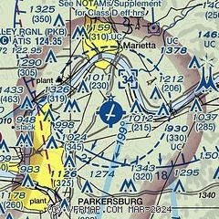
| Sectional chart |
|---|
|
 Download PDF
of official airport diagram from the FAA
| Airport distance calculator |
|---|
|
|
| Sunrise and sunset |
|---|
|
Times for 13-Jul-2026
| | Local
(UTC-4) | | Zulu
(UTC) |
|---|
| Morning civil twilight | | 05:39 | | 09:39 |
| Sunrise | | 06:11 | | 10:11 |
| Sunset | | 20:52 | | 00:52 |
| Evening civil twilight | | 21:24 | | 01:24 |
|
| Current date and time |
|---|
| Zulu (UTC) | 13-Jul-2026 17:53:42 |
|---|
| Local (UTC-4) | 13-Jul-2026 13:53:42 |
|---|
|
| METAR |
|---|
| KPKB | 131653Z VRB04KT 10SM SCT036 29/19 A3017 RMK AO2 SLP209 T02890189
|
|
| TAF |
|---|
| KPKB | 131251Z 1313/1412 09004KT P6SM SCT010 FM131700 09005KT P6SM SCT035 FM140000 09002KT P6SM FEW250 FM140700 00000KT 2SM BR FEW250
|
|
| NOTAMs |
|---|
NOTAMs are issued by the DoD/FAA and will open in a separate window not controlled by AirNav.
|
|


