FAA INFORMATION EFFECTIVE 14 MAY 2026
Location
| FAA Identifier: | I95 |
| Lat/Long: | 40-36-36.3330N 083-38-39.3334W
40-36.605550N 083-38.655557W
40.6100925,-83.6442593
(estimated) |
| Elevation: | 1029 ft. / 313.6 m (surveyed) |
| Variation: | 06W (2010) |
| From city: | 3 miles SW of KENTON, OH |
| Time zone: | UTC -4 (UTC -5 during Standard Time) |
| Zip code: | 43326 |
Airport Operations
| Airport use: | Open to the public |
| Activation date: | 07/1968 |
| Control tower: | no |
| ARTCC: | INDIANAPOLIS CENTER |
| FSS: | DAYTON FLIGHT SERVICE STATION |
| NOTAMs facility: | I95 (NOTAM-D service available) |
| Attendance: | SAT-SUN 0900-1700, ALL MON-FRI 0900-1800
UNATNDD MAJOR HOLS. |
| Wind indicator: | lighted |
| Segmented circle: | no |
| Lights: | ACTVT MIRL RWY 04/22 - 3 CLICKS CTAF WI 3 SECS. |
| Beacon: | white-green (lighted land airport)
Operates sunset to sunrise. |
Airport Communications
| CTAF/UNICOM: | 122.8 |
| WX AWOS-3: | 126.4 (419-675-0781) |
| COLUMBUS APPROACH: | 134.45 |
| COLUMBUS DEPARTURE: | 134.45 |
| WX AWOS-3 at EDJ (16 nm SW): | 118.075 (937-599-4654) |
| WX ASOS at AOH (18 nm W): | 128.725 (419-224-6098) |
Nearby radio navigation aids
| VOR radial/distance | | VOR name | | Freq | | Var |
|---|
| FBCr168/21.3 | | FLAG CITY VORTAC | | 108.20 | | 02W |
| BUDr274/(26.4) | | BUCKEYE VOR | | 109.80 | | 05W |
| RODr048/26.6 | | ROSEWOOD VORTAC | | 117.50 | | 05W |
| NDB name | | Hdg/Dist | | Freq | | Var | | ID |
|---|
| TIFFIN | | 219/35.0 | | 269 | | 05W | | TII | - .. .. |
Airport Services
| Fuel available: | 100LL JET-A1+
A1+:FULL SERVE ONLY, AFT HRS CALL 419-673-9542.
100LL:FULL SERVE ONLY, AFT HRS CALL 419-673-9542. |
| Parking: | hangars and tiedowns |
| Airframe service: | MAJOR |
| Powerplant service: | MAJOR |
| Bottled oxygen: | NONE |
| Bulk oxygen: | NONE |
Runway Information
Runway 4/22
| Dimensions: | 4797 x 75 ft. / 1462 x 23 m |
| Surface: | asphalt, in good condition |
| Weight bearing capacity: | |
| Runway edge lights: | medium intensity |
| RUNWAY 4 | | RUNWAY 22 |
| Latitude: | 40-36.301475N | | 40-36.909615N |
| Longitude: | 083-38.986277W | | 083-38.324792W |
| Elevation: | 1029.0 ft. | | 1003.6 ft. |
| Traffic pattern: | right | | left |
| Runway heading: | 046 magnetic, 040 true | | 226 magnetic, 220 true |
| Markings: | nonprecision, in good condition | | nonprecision, in good condition |
| Runway end identifier lights: | no | | no |
| Touchdown point: | yes, no lights | | yes, no lights |
| Obstructions: | 80 ft. trees, 1697 ft. from runway, 212 ft. right of centerline, 18:1 slope to clear | | 30 ft. acft, 201 ft. from runway, 220 ft. right of centerline
30 FT TWY, 0-200 FT DIST, 220-250 FT R. |
Airport Ownership and Management from official FAA records
| Ownership: | Publicly-owned |
| Owner: | HARDIN CO ARPT AUTH
20783 COUNTY ROAD 200
KENTON, OH 43326
Phone 567-674-9355 |
| Manager: | ED MCCORMICK
13975 COUNTY ROAD 135
KENTON, OH 43326-9304
Phone 419-673-9542 |
Additional Remarks
| - | DEER & BIRDS ON & INVOF ARPT. |
| - | FOR CD CTC COLUMBUS APCH AT 614-338-8537. |
Instrument Procedures
NOTE: All procedures below are presented as PDF files. If you need a reader for these files, you should download the free Adobe Reader.NOT FOR NAVIGATION. Please procure official charts for flight.
FAA instrument procedures published for use from 14 May 2026 at 0901Z to 11 June 2026 at 0900Z.
IAPs - Instrument Approach Procedures |
|---|
| RNAV (GPS) RWY 04 | |
download (232KB) |
| RNAV (GPS) RWY 22 | |
download (192KB) |
| NOTE: Special Take-Off Minimums/Departure Procedures apply | |
download (164KB) |
Other nearby airports with instrument procedures:
KEDJ - Bellefontaine Regional Airport (16 nm SW)
KAOH - Lima Allen County Airport (18 nm W)
5G7 - Bluffton Airport (19 nm NW)
56D - Wyandot County Airport (22 nm NE)
KFDY - Findlay Airport (24 nm N)
|
|

Road maps at:
MapQuest
Bing
Google
| Aerial photo |
|---|
WARNING: Photo may not be current or correct
 Photo taken 23-Aug-2016
looking northeast
Photo taken 23-Aug-2016
looking northeast
Do you have a better or more recent aerial photo of Hardin County Airport that you would like to share? If so, please send us your photo.
|
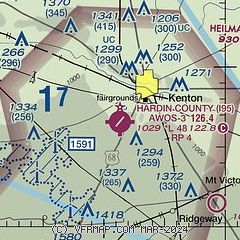
| Sectional chart |
|---|
|
| Airport distance calculator |
|---|
|
|
| Sunrise and sunset |
|---|
|
Times for 16-May-2026
| | Local
(UTC-4) | | Zulu
(UTC) |
|---|
| Morning civil twilight | | 05:47 | | 09:47 |
| Sunrise | | 06:18 | | 10:18 |
| Sunset | | 20:44 | | 00:44 |
| Evening civil twilight | | 21:15 | | 01:15 |
|
| Current date and time |
|---|
| Zulu (UTC) | 16-May-2026 22:44:33 |
|---|
| Local (UTC-4) | 16-May-2026 18:44:33 |
|---|
|
| METAR |
|---|
KEDJ
16nm SW | 162226Z AUTO 27008KT 10SM CLR 23/18 A2995 RMK AO1
|
KAOH
18nm W | 162153Z AUTO 26016G28KT 10SM CLR 23/17 A2993 RMK AO2 PK WND 25028/2149 SLP129 T02330172
|
KFDY
24nm N | 162153Z AUTO 27014G21KT 10SM CLR 26/17 A2989 RMK AO2 PK WND 25029/2110 SLP115 T02560172
|
KMNN
26nm E | 162153Z AUTO 25012G19KT 10SM SCT034 24/18 A2994 RMK AO2 SLP135 T02440178 $
|
KMRT
27nm SE | 162235Z AUTO 26009KT 10SM FEW037 24/18 A2994 RMK AO2 LTG DSNT S
|
KI74
29nm S | 162235Z AUTO 26003KT 10SM CLR 23/17 A2995 RMK AO2
|
KOWX
30nm NW | 162235Z AUTO 25011G16KT 10SM SCT034 SCT042 26/20 A2991 RMK AO2
|
KAXV
31nm W | 162235Z AUTO 26004KT 10SM CLR 22/17 A2993 RMK AO2
|
KDLZ
31nm SE | 162235Z AUTO 24005KT 10SM CLR 24/21 A2994 RMK AO2
|
|
| TAF |
|---|
KFDY
24nm N | 161738Z 1618/1718 23015G25KT P6SM BKN060 FM162200 22009KT P6SM BKN080 FM171600 19008KT P6SM SCT035
|
|
| NOTAMs |
|---|
NOTAMs are issued by the DoD/FAA and will open in a separate window not controlled by AirNav.
|
|


