FAA INFORMATION EFFECTIVE 27 NOVEMBER 2025
Location
| FAA Identifier: | IUA |
| Lat/Long: | 42-54-32.0468N 077-19-30.8146W
42-54.534113N 077-19.513577W
42.9089019,-77.3252263
(estimated) |
| Elevation: | 813.6 ft. / 248.0 m (surveyed) |
| Variation: | 12W (2000) |
| From city: | 3 miles NW of CANANDAIGUA, NY |
| Time zone: | UTC -5 (UTC -4 during Daylight Saving Time) |
| Zip code: | 14424 |
Airport Operations
| Airport use: | Open to the public |
| Activation date: | 04/1948 |
| Control tower: | no |
| ARTCC: | CLEVELAND CENTER |
| FSS: | BUFFALO FLIGHT SERVICE STATION |
| NOTAMs facility: | BUF (NOTAM-D service available) |
| Attendance: | CONTINUOUS
7AM-5PM DLY, CALL FBO FOR AFT HRS SVC. |
| Wind indicator: | lighted |
| Segmented circle: | yes |
| Lights: | ACTVT REIL RWY 13 & 31; PAPI RWY 13 & 31; MIRL RWY 13/31 - CTAF. |
| Beacon: | white-green (lighted land airport)
Operates sunset to sunrise. |
Airport Communications
| CTAF/UNICOM: | 122.8 |
| WX AWOS-3P: | 118.675 (585-396-5861) |
| ROCHESTER APPROACH: | 119.55 |
| ROCHESTER DEPARTURE: | 119.55 |
| WX ASOS at ROC (20 nm NW): | 124.825 (585-205-7835) |
Nearby radio navigation aids
| VOR radial/distance | | VOR name | | Freq | | Var |
|---|
| GEEr085/18.5 | | GENESEO VOR/DME | | 108.20 | | 09W |
| ROCr141/19.7 | | ROCHESTER VOR/DME | | 110.00 | | 12W |
Airport Services
| Fuel available: | 100LL JET-A+ |
| Parking: | hangars and tiedowns |
| Airframe service: | MAJOR |
| Powerplant service: | MAJOR |
| Bottled oxygen: | NONE |
| Bulk oxygen: | NONE |
Runway Information
Runway 13/31
| Dimensions: | 5500 x 100 ft. / 1676 x 30 m |
| Surface: | asphalt/grooved, in good condition |
| Weight bearing capacity: | |
| Runway edge lights: | medium intensity |
| RUNWAY 13 | | RUNWAY 31 |
| Latitude: | 42-54.780987N | | 42-54.287240N |
| Longitude: | 077-20.029750W | | 077-18.997403W |
| Elevation: | 788.6 ft. | | 811.9 ft. |
| Traffic pattern: | left | | left |
| Runway heading: | 135 magnetic, 123 true | | 315 magnetic, 303 true |
| Markings: | nonprecision, in good condition | | nonprecision, in good condition |
| Visual slope indicator: | 2-light PAPI on left (3.00 degrees glide path) | | 2-light PAPI on right (3.00 degrees glide path) |
| Runway end identifier lights: | yes | | yes |
| Touchdown point: | yes, no lights | | yes, no lights |
| Obstructions: | 32 ft. tree, 1331 ft. from runway, 187 ft. right of centerline, 35:1 slope to clear | | 38 ft. tree, 1069 ft. from runway, 131 ft. right of centerline, 22:1 slope to clear
9 FT BUSH AND FENCE 176 FT FM THR, 243 FT LEFT. |
Airport Ownership and Management from official FAA records
| Ownership: | Publicly-owned |
| Owner: | ONTARIO COUNTY IDA
20 ONTARIO ST
CANANDAIGUA, NY 14425
Phone 585-396-4460 |
| Manager: | BOB MINCER
20 ONTARIO ST, C/O ONTARIO COUNTY IDA
CANANDAIGUA, NY 14425
Phone 585-919-2772 |
Additional Remarks
| - | FOR SVCS AND ARPT CONDS CALL 585-394-4780. |
| - | FQT MEDIVAC HEL OPNS: MNT CTAF. |
| - | FOR CD CTC CLEVELAND ARTCC AT 440-774-0490. |
Instrument Procedures
NOTE: All procedures below are presented as PDF files. If you need a reader for these files, you should download the free Adobe Reader.NOT FOR NAVIGATION. Please procure official charts for flight.
FAA instrument procedures published for use from 27 November 2025 at 0901Z to 25 December 2025 at 0900Z.
IAPs - Instrument Approach Procedures |
|---|
| RNAV (GPS) RWY 13 **CHANGED** | |
download (255KB) |
| RNAV (GPS) RWY 31 **CHANGED** | |
download (247KB) |
| VOR-A **CHANGED** | |
download (213KB) |
| NOTE: Special Take-Off Minimums/Departure Procedures apply | |
download (291KB) |
Other nearby airports with instrument procedures:
KROC - Frederick Douglass/Greater Rochester International Airport (20 nm NW)
KPEO - Penn Yan/Yates County Airport (20 nm SE)
KSDC - Williamson/Sodus Airport (22 nm NE)
0G7 - Finger Lakes Regional Airport (24 nm E)
KDSV - Dansville Municipal Airport (27 nm SW)
|
|

Road maps at:
MapQuest
Bing
Google
| Aerial photo |
|---|
WARNING: Photo may not be current or correct
 Photo by Bob Mincer
Photo taken 27-Jun-2019
looking south.
Photo by Bob Mincer
Photo taken 27-Jun-2019
looking south.
Do you have a better or more recent aerial photo of Canandaigua Airport that you would like to share? If so, please send us your photo.
|
| Sectional chart |
|---|
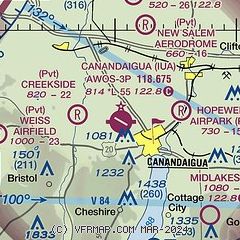
|
| Airport distance calculator |
|---|
|
|
| Sunrise and sunset |
|---|
|
Times for 19-Dec-2025
| | Local
(UTC-5) | | Zulu
(UTC) |
|---|
| Morning civil twilight | | 07:05 | | 12:05 |
| Sunrise | | 07:37 | | 12:37 |
| Sunset | | 16:36 | | 21:36 |
| Evening civil twilight | | 17:08 | | 22:08 |
|
| Current date and time |
|---|
| Zulu (UTC) | 19-Dec-2025 18:47:25 |
|---|
| Local (UTC-5) | 19-Dec-2025 13:47:25 |
|---|
|
| METAR |
|---|
| KIUA | 191735Z AUTO 27020G34KT 10SM OVC021 01/M03 A2941 RMK AO2 T00051026
|
KPEO
20nm SE | 191826Z AUTO 27017G25KT 5SM -SN SCT022 SCT033 OVC060 01/M03 A2935 RMK AO2 PK WND 26034/1807 RAE04SNB08 P0001 T00061028
|
|
| TAF |
|---|
KROC
20nm NW | 191727Z 1918/2018 27030G43KT P6SM BKN020 TEMPO 1918/1921 4SM -SHSN OVC015 FM192100 26021G38KT P6SM OVC035 FM200300 28019G31KT P6SM OVC025 PROB30 2003/2005 4SM -SHSN OVC015 FM200800 28014G24KT P6SM OVC035 FM201000 26009KT P6SM BKN045
|
|
| NOTAMs |
|---|
NOTAMs are issued by the DoD/FAA and will open in a separate window not controlled by AirNav.
|
|

