FAA INFORMATION EFFECTIVE 16 APRIL 2026
Location
| FAA Identifier: | SDC |
| Lat/Long: | 43-14-04.5510N 077-07-10.0700W
43-14.075850N 077-07.167833W
43.2345975,-77.1194639
(estimated) |
| Elevation: | 424.3 ft. / 129.3 m (surveyed) |
| Variation: | 12W (1995) |
| From city: | 3 miles W of central business district of the associated city |
| Time zone: | UTC -4 (UTC -5 during Standard Time) |
| Zip code: | 14589 |
Airport Operations
| Airport use: | Open to the public |
| Control tower: | no |
| ARTCC: | CLEVELAND CENTER |
| FSS: | BUFFALO FLIGHT SERVICE STATION |
| NOTAMs facility: | BUF (NOTAM-D service available) |
| Attendance: | MON-FRI 0830-1700 |
| Pattern altitude: | 1400.3 ft. MSL |
| Wind indicator: | lighted |
| Segmented circle: | yes |
| Lights: | ACTIVATE REIL RWY 10 & 28; MIRL RWY 10/28 - CTAF. |
| Beacon: | white-green (lighted land airport)
Operates sunset to sunrise. |
Airport Communications
| CTAF/UNICOM: | 122.8 |
| WX AWOS-3: | 124.2 (315-483-6171) |
| ROCHESTER APPROACH: | 119.55 |
| ROCHESTER DEPARTURE: | 119.55 |
Nearby radio navigation aids
| VOR radial/distance | | VOR name | | Freq | | Var |
|---|
| ROCr086/25.2 | | ROCHESTER VOR/DME | | 110.00 | | 12W |
| GEEr057/36.1 | | GENESEO VOR/DME | | 108.20 | | 09W |
Airport Services
| Fuel available: | 100LL
100LL:CREDIT CARD FUEL AVBL 24 HRS. |
| Parking: | tiedowns |
| Airframe service: | MAJOR |
| Powerplant service: | MAJOR |
| Bottled oxygen: | NONE |
| Bulk oxygen: | NONE |
Runway Information
Runway 10/28
| Dimensions: | 3803 x 60 ft. / 1159 x 18 m |
| Surface: | asphalt, in good condition |
| Weight bearing capacity: | |
| Runway edge lights: | medium intensity |
| RUNWAY 10 | | RUNWAY 28 |
| Latitude: | 43-14.067197N | | 43-14.084468N |
| Longitude: | 077-07.595742W | | 077-06.739932W |
| Elevation: | 424.2 ft. | | 418.8 ft. |
| Traffic pattern: | left | | left |
| Runway heading: | 100 magnetic, 088 true | | 280 magnetic, 268 true |
| Markings: | nonprecision, in good condition | | nonprecision, in good condition |
| Visual slope indicator: | 2-light PAPI on left (3.00 degrees glide path) | | 2-light PAPI on right (3.20 degrees glide path) |
| Runway end identifier lights: | yes | | yes |
| Touchdown point: | yes, no lights | | yes, no lights |
| Obstructions: | 30 ft. trees, 261 ft. from runway, 177 ft. left of centerline, 2:1 slope to clear
+8 FT FENCE 131 FT FROM THLD 226 FT L OF CNTLN. | | 70 ft. tree, 401 ft. from runway, 277 ft. right of centerline, 2:1 slope to clear |
Airport Ownership and Management from official FAA records
| Ownership: | Privately-owned |
| Owner: | WILLIAMSON FLYING CLUB INC
PO BOX 148
WILLIAMSON, NY 14589
Phone 315-483-6011 |
| Manager: | MIKE BJERGA
PO BOX 148
WILLIAMSON, NY 14589
Phone 315-483-6011 |
Additional Remarks
| - | AREAS OTHER THAN RWY & TWY MAY BE VERY SOFT IN FALL, WINTER & SPRING. |
| - | GEESE & DEER ON & INVOF ARPT. |
| - | FOR CD CTC CLEVELAND ARTCC AT 440-774-0490. |
Instrument Procedures
NOTE: All procedures below are presented as PDF files. If you need a reader for these files, you should download the free Adobe Reader.NOT FOR NAVIGATION. Please procure official charts for flight.
FAA instrument procedures published for use from 16 April 2026 at 0901Z to 14 May 2026 at 0900Z.
IAPs - Instrument Approach Procedures |
|---|
| RNAV (GPS) RWY 10 | |
download (240KB) |
| RNAV (GPS) RWY 28 | |
download (232KB) |
| NOTE: Special Alternate Minimums apply | |
download (144KB) |
| NOTE: Special Take-Off Minimums/Departure Procedures apply | |
download (453KB) |
Other nearby airports with instrument procedures:
KIUA - Canandaigua Airport (22 nm SW)
KROC - Frederick Douglass/Greater Rochester International Airport (25 nm W)
0G7 - Finger Lakes Regional Airport (26 nm SE)
B16 - Whitfords Airport (27 nm E)
KFZY - Oswego County Airport (33 nm E)
|
|

Road maps at:
MapQuest
Bing
Google
| Aerial photo |
|---|
WARNING: Photo may not be current or correct

Do you have a better or more recent aerial photo of Williamson/Sodus Airport that you would like to share? If so, please send us your photo.
|
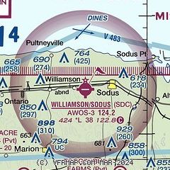
| Sectional chart |
|---|
|
| Airport distance calculator |
|---|
|
|
| Sunrise and sunset |
|---|
|
Times for 11-May-2026
| | Local
(UTC-4) | | Zulu
(UTC) |
|---|
| Morning civil twilight | | 05:18 | | 09:18 |
| Sunrise | | 05:50 | | 09:50 |
| Sunset | | 20:20 | | 00:20 |
| Evening civil twilight | | 20:52 | | 00:52 |
|
| Current date and time |
|---|
| Zulu (UTC) | 11-May-2026 11:48:20 |
|---|
| Local (UTC-4) | 11-May-2026 07:48:20 |
|---|
|
| METAR |
|---|
| KSDC | 111135Z AUTO 00000KT 10SM OVC110 06/03 A3017 RMK AO2
|
|
| TAF |
|---|
KROC
26nm W | 110520Z 1106/1206 VRB03KT P6SM SKC FM110900 VRB03KT P6SM BKN070 FM111400 30005KT P6SM BKN060 FM111700 32009KT P6SM BKN050 FM112300 30007KT P6SM SCT050 FM120200 VRB03KT P6SM SKC
|
|
| NOTAMs |
|---|
NOTAMs are issued by the DoD/FAA and will open in a separate window not controlled by AirNav.
|
|

