FAA INFORMATION EFFECTIVE 14 MAY 2026
Location
| FAA Identifier: | JAS |
| Lat/Long: | 30-53-08.5000N 094-02-05.8000W
30-53.141667N 094-02.096667W
30.8856944,-94.0349444
(estimated) |
| Elevation: | 212.6 ft. / 64.8 m (surveyed) |
| Variation: | 04E (1995) |
| From city: | 4 miles SW of JASPER, TX |
| Time zone: | UTC -5 (UTC -6 during Standard Time) |
| Zip code: | 75951 |
Airport Operations
| Airport use: | Open to the public |
| Activation date: | 06/1951 |
| Control tower: | no |
| ARTCC: | HOUSTON CENTER |
| FSS: | MONTGOMERY COUNTY FLIGHT SERVICE STATION |
| NOTAMs facility: | JAS (NOTAM-D service available) |
| Attendance: | 0800-1700 |
| Wind indicator: | lighted |
| Segmented circle: | yes |
| Lights: | MIRL RWY 18/36 PRESET LOW INTST; TO INCR INTST ACTVT - CTAF. |
| Beacon: | white-green (lighted land airport)
Operates sunset to sunrise. |
Airport Communications
| CTAF/UNICOM: | 122.8 |
| WX AWOS-3: | 118.375 (409-489-1603) |
- COMMUNICATIONS PRVDD BY MONTGOMERY COUNTY RADIO ON FREQ 122.5 (JASPER RCO).
- APCH/DEP CTL SVC PRVDD BY HOUSTON ARTCC (ZHU) ON FREQS 126.95/363.05 (NEWTON RCAG).
Nearby radio navigation aids
| VOR radial/distance | | VOR name | | Freq | | Var |
|---|
| LFKr110/38.8 | | LUFKIN VORTAC | | 112.10 | | 05E |
Airport Services
| Fuel available: | 100LL JET-A |
| Parking: | hangars and tiedowns |
| Airframe service: | MAJOR |
| Powerplant service: | MAJOR |
| Bottled oxygen: | NONE |
| Bulk oxygen: | NONE |
Runway Information
Runway 18/36
| Dimensions: | 5500 x 70 ft. / 1676 x 21 m |
| Surface: | asphalt, in good condition |
| Weight bearing capacity: | |
| Runway edge lights: | medium intensity |
| RUNWAY 18 | | RUNWAY 36 |
| Latitude: | 30-53.596005N | | 30-52.688883N |
| Longitude: | 094-02.087527W | | 094-02.104890W |
| Elevation: | 212.5 ft. | | 177.6 ft. |
| Traffic pattern: | left | | left |
| Runway heading: | 177 magnetic, 181 true | | 357 magnetic, 001 true |
| Markings: | nonprecision, in good condition | | nonprecision, in good condition |
| Visual slope indicator: | 2-light PAPI on left (3.50 degrees glide path) | | 2-light PAPI on left (3.50 degrees glide path) |
| Touchdown point: | yes, no lights | | yes, no lights |
| Obstructions: | 90 ft. trees, 2550 ft. from runway, 1265 ft. left and right of centerline, 26:1 slope to clear | | 80 ft. trees, 1980 ft. from runway, 550 ft. left and right of centerline, 24:1 slope to clear |
Airport Ownership and Management from official FAA records
| Ownership: | Publicly-owned |
| Owner: | JASPER COUNTY
JASPER COUNTY COURTHOUSE, 121 N. AUSTIN STREET
JASPER, TX 75951
Phone 409-384-5343 |
| Manager: | CHRIS RUIZ
193 CARNES B MANNING DR
JASPER, TX 75951
Phone 409-384-5343
EMER AFT HRS 409-382-2835 |
Additional Remarks
| - | FOR CD IF UNA TO CTC ON FSS FREQ, CTC HOUSTON ARTCC AT 281-230-5622. |
Instrument Procedures
NOTE: All procedures below are presented as PDF files. If you need a reader for these files, you should download the free Adobe Reader.NOT FOR NAVIGATION. Please procure official charts for flight.
FAA instrument procedures published for use from 14 May 2026 at 0901Z to 11 June 2026 at 0900Z.
IAPs - Instrument Approach Procedures |
|---|
| RNAV (GPS) RWY 18 | |
download (277KB) |
| RNAV (GPS) RWY 36 | |
download (269KB) |
| NOTE: Special Alternate Minimums apply | |
download (124KB) |
| NOTE: Special Take-Off Minimums/Departure Procedures apply | |
download (207KB) |
Other nearby airports with instrument procedures:
45R - Hawthorne Field Airport (35 nm S)
KDRI - Beauregard Regional Airport (36 nm E)
5R8 - De Quincy Industrial Airpark (39 nm SE)
L39 - Leesville Airport (39 nm NE)
KLFK - Angelina County Airport (42 nm NW)
|
|

Road maps at:
MapQuest
Bing
Google
| Aerial photo |
|---|
WARNING: Photo may not be current or correct
 Photo courtesy Jasper Economic Development Corp.
Taken in the Summer of 2004
Photo courtesy Jasper Economic Development Corp.
Taken in the Summer of 2004
Do you have a better or more recent aerial photo of Jasper County Airport-Bell Field that you would like to share? If so, please send us your photo.
|
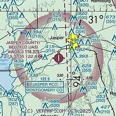
| Sectional chart |
|---|
|
CAUTION: Diagram may not be current

| Airport distance calculator |
|---|
|
|
| Sunrise and sunset |
|---|
|
Times for 25-May-2026
| | Local
(UTC-5) | | Zulu
(UTC) |
|---|
| Morning civil twilight | | 05:50 | | 10:50 |
| Sunrise | | 06:17 | | 11:17 |
| Sunset | | 20:09 | | 01:09 |
| Evening civil twilight | | 20:36 | | 01:36 |
|
| Current date and time |
|---|
| Zulu (UTC) | 25-May-2026 06:30:52 |
|---|
| Local (UTC-5) | 25-May-2026 01:30:52 |
|---|
|
| METAR |
|---|
| KJAS | 250615Z AUTO 00000KT 8SM CLR 21/21 A2996 RMK AO2
|
|
| TAF |
|---|
KLFK
42nm NW | 250539Z 2506/2606 VRB03KT P6SM FEW045 BKN250 FM250900 00000KT 4SM BR SCT003 SCT250 FM251100 00000KT 2SM BR BKN003 FM251400 VRB03KT P6SM SCT006 SCT250 FM251800 08005KT P6SM SCT040 SCT250 FM252100 08005KT P6SM VCTS BKN045CB FM260200 VRB03KT P6SM BKN250
|
|
| NOTAMs |
|---|
NOTAMs are issued by the DoD/FAA and will open in a separate window not controlled by AirNav.
|
|


