FAA INFORMATION EFFECTIVE 09 JULY 2026
Location
| FAA Identifier: | AIA |
| Lat/Long: | 42-03-11.6000N 102-48-13.5000W
42-03.193333N 102-48.225000W
42.0532222,-102.8037500
(estimated) |
| Elevation: | 3930.6 ft. / 1198.0 m (surveyed) |
| Variation: | 07E (2020) |
| From city: | 3 miles SE of ALLIANCE, NE |
| Time zone: | UTC -6 (UTC -7 during Standard Time) |
| Zip code: | 69301 |
Airport Operations
| Airport use: | Open to the public |
| Activation date: | 02/1944 |
| Control tower: | no |
| ARTCC: | DENVER CENTER |
| FSS: | COLUMBUS FLIGHT SERVICE STATION |
| NOTAMs facility: | AIA (NOTAM-D service available) |
| Attendance: | CONTINUOUS |
| Wind indicator: | lighted |
| Segmented circle: | yes |
| Lights: | ACTVT MALSR RWY 30; REIL RWY 12; VASI RWY 12; PAPI RWY 30 & MIRL RWY 12/30 & 08/26 -CTAF. |
| Beacon: | white-green (lighted land airport)
Operates sunset to sunrise. |
| Fire and rescue: | ARFF index A |
Airport Communications
| CTAF/UNICOM: | 123.0 |
| WX ASOS: | 135.075 (308-762-1221) |
- APCH/DEP CTL SVC PRVDD BY DENVER ARTCC (ZDV) ON FREQS 127.95/338.2 (CRAWFORD RCAG).
Nearby radio navigation aids
| VOR radial/distance | | VOR name | | Freq | | Var |
|---|
| AIA at field | | ALLIANCE VOR/DME | | 111.80 | | 11E |
| BFFr059/31.7 | | SCOTTSBLUFF VORTAC | | 112.60 | | 13E |
| TSTr130/37.8 | | TOADSTOOL VOR/DME | | 113.40 | | 13E |
Airport Services
| Fuel available: | 100LL JET-A |
| Parking: | hangars and tiedowns |
| Airframe service: | MAJOR |
| Powerplant service: | MAJOR |
| Bottled oxygen: | NONE |
Runway Information
Runway 12/30
| Dimensions: | 9203 x 150 ft. / 2805 x 46 m |
| Surface: | asphalt/aggregate friction seal coat, in excellent condition |
| Weight bearing capacity: | | Single wheel: | 98.0 | | Double wheel: | 285.0 | | Double tandem: | 158.0 | | Dual double tandem: | 321.0 |
|
| Runway edge lights: | medium intensity |
| RUNWAY 12 | | RUNWAY 30 |
| Latitude: | 42-03.599995N | | 42-02.541778N |
| Longitude: | 102-49.115627W | | 102-47.661127W |
| Elevation: | 3929.8 ft. | | 3924.5 ft. |
| Traffic pattern: | left | | left |
| Runway heading: | 127 magnetic, 134 true | | 307 magnetic, 314 true |
| Declared distances: | TORA:9203 TODA:9203 ASDA:9203 LDA:9203 | | TORA:9203 TODA:9203 ASDA:9203 LDA:9203 |
| Markings: | nonprecision, in good condition | | precision, in good condition |
| Visual slope indicator: | 4-box VASI on left (3.00 degrees glide path) | | 4-light PAPI on left (3.00 degrees glide path) |
| Approach lights: | | | MALSR: 1,400 foot medium intensity approach lighting system with runway alignment indicator lights |
| Runway end identifier lights: | yes | | no |
| Touchdown point: | yes, no lights | | yes, no lights |
| Instrument approach: | | | ILS/DME |
Runway 17/35
| Dimensions: | 6311 x 75 ft. / 1924 x 23 m |
| Surface: | asphalt, in poor condition |
| Weight bearing capacity: | | Single wheel: | 24.0 | | Double wheel: | 30.0 |
|
| Operational restrictions: | RWY 17/35 NOT AVBL FOR PART 121/PART 380 OPS WITH SKED PAX CARRYING OPS MORE THAN 9 PAX SEATS AND NON-SKED PAX CARRYING OPS MORE THAN 30 PAX SEATS. |
| RUNWAY 17 | | RUNWAY 35 |
| Latitude: | 42-03.564722N | | 42-02.525835N |
| Longitude: | 102-47.706095W | | 102-47.689625W |
| Elevation: | 3924.6 ft. | | 3925.2 ft. |
| Traffic pattern: | left | | left |
| Runway heading: | 172 magnetic, 179 true | | 352 magnetic, 359 true |
| Declared distances: | TORA:6311 TODA:6311 ASDA:6311 LDA:6311 | | TORA:6311 TODA:6311 ASDA:6311 LDA:6311 |
| Markings: | basic, in fair condition | | basic, in fair condition |
| Touchdown point: | yes, no lights | | yes, no lights |
Runway 8/26
| Dimensions: | 6190 x 75 ft. / 1887 x 23 m |
| Surface: | asphalt/porous friction courses, in good condition |
| Weight bearing capacity: | | Single wheel: | 36.0 | | Double wheel: | 48.0 | | Double tandem: | 80.0 |
|
| Runway edge lights: | medium intensity |
| RUNWAY 8 | | RUNWAY 26 |
| Latitude: | 42-03.520312N | | 42-03.532465N |
| Longitude: | 102-49.205802W | | 102-47.838657W |
| Elevation: | 3930.6 ft. | | 3924.9 ft. |
| Traffic pattern: | left | | left |
| Runway heading: | 082 magnetic, 089 true | | 262 magnetic, 269 true |
| Declared distances: | TORA:6190 TODA:6190 ASDA:6190 LDA:6190 | | TORA:6190 TODA:6190 ASDA:6190 LDA:6190 |
| Markings: | nonprecision, in good condition | | nonprecision, in good condition |
| Touchdown point: | yes, no lights | | yes, no lights |
Airport Ownership and Management from official FAA records
| Ownership: | Publicly-owned |
| Owner: | CITY OF ALLIANCE
PO BOX D
ALLIANCE, NE 69301
Phone 308-762-5400 |
| Manager: | MS LYNN PLACEK
5631 SARPY ROAD, PO BOX D
ALLIANCE, NE 69301
Phone 308-762-4512 |
Additional Remarks
| A39-12/30 | PCR VALUE: 39/R/B/W/T |
| A39-17/35 | PCR VALUE: 39/R/B/W/T |
| A39-08/26 | PCR VALUE: 39/R/B/W/T |
| - | FOR CD IF UNA TO CTC ON FSS FREQ, CTC DENVER ARTCC AT 303-651-4257. |
| - | ULTRALIGHT & GLIDER OPNS ON & INVOF ARPT. |
| - | AERIAL SPRAYING OPNS ON & INVOF ARPT. |
| - | RY 08/26 DESIGNATED CALM WIND. |
| - | HAYING OPNS ON INTERIOR OF ARPT DURG SUMMER MONTHS. |
| - | OCCASIONAL USE BY ACFT WITH NO RADIO. |
| - | BACK TAXIING. |
| - | MIGRATORY WATERFOWL ON & INVOF ARPT. |
Instrument Procedures
NOTE: All procedures below are presented as PDF files. If you need a reader for these files, you should download the free Adobe Reader.NOT FOR NAVIGATION. Please procure official charts for flight.
FAA instrument procedures published for use from 09 July 2026 at 0901Z to 06 August 2026 at 0900Z.
IAPs - Instrument Approach Procedures |
|---|
| ILS OR LOC RWY 30 | |
download (214KB) |
| RNAV (GPS) RWY 08 | |
download (192KB) |
| RNAV (GPS) RWY 12 | |
download (206KB) |
| RNAV (GPS) RWY 26 | |
download (169KB) |
| RNAV (GPS) RWY 30 | |
download (223KB) |
| VOR RWY 12 | |
download (142KB) |
| VOR RWY 30 | |
download (157KB) |
| NOTE: Special Alternate Minimums apply | |
download (141KB) |
Other nearby airports with instrument procedures:
KBFF - Scottsbluff (Western Nebraska Regional Airport) William B Heilig Field (37 nm W)
KOKS - Garden County Airport/King Rhiley Field (44 nm SE)
9V5 - Modisett Airport (44 nm N)
KCDR - Chadron Municipal Airport (49 nm N)
KGRN - Gordon Municipal Airport (53 nm NE)
|
|

Road maps at:
MapQuest
Bing
Google
| Aerial photo |
|---|
WARNING: Photo may not be current or correct
 Photo by Blaine E. Fisher
Photo taken 17-Sep-2005
Photo by Blaine E. Fisher
Photo taken 17-Sep-2005
Do you have a better or more recent aerial photo of Alliance Municipal Airport that you would like to share? If so, please send us your photo.
|
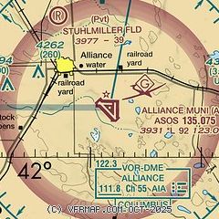
| Sectional chart |
|---|
|
 Download PDF
of official airport diagram from the FAA
| Airport distance calculator |
|---|
|
|
| Sunrise and sunset |
|---|
|
Times for 29-Jul-2026
| | Local
(UTC-6) | | Zulu
(UTC) |
|---|
| Morning civil twilight | | 05:11 | | 11:11 |
| Sunrise | | 05:43 | | 11:43 |
| Sunset | | 20:13 | | 02:13 |
| Evening civil twilight | | 20:45 | | 02:45 |
|
| Current date and time |
|---|
| Zulu (UTC) | 29-Jul-2026 06:11:48 |
|---|
| Local (UTC-6) | 29-Jul-2026 00:11:48 |
|---|
|
| METAR |
|---|
| KAIA | 290553Z AUTO 09005KT 10SM CLR 20/18 A3005 RMK AO2 SLP125 T02000178 10244 20200 53004
|
|
| TAF |
|---|
| KAIA | 290541Z 2906/3006 VRB06KT P6SM SCT150 FM291100 VRB06KT P6SM SCT250 FM291500 17010KT P6SM FEW250 FM291800 16015G25KT P6SM FEW250 FM300200 20012KT P6SM VCTS BKN150CB
|
|
| NOTAMs |
|---|
NOTAMs are issued by the DoD/FAA and will open in a separate window not controlled by AirNav.
|
|


