FAA INFORMATION EFFECTIVE 09 JULY 2026
Location
| FAA Identifier: | ASN |
| Lat/Long: | 33-34-10.2150N 086-03-04.3250W
33-34.170250N 086-03.072083W
33.5695042,-86.0512014
(estimated) |
| Elevation: | 528.8 ft. / 161.2 m (surveyed) |
| Variation: | 03W (2010) |
| From city: | 8 miles NE of TALLADEGA, AL |
| Time zone: | UTC -5 (UTC -6 during Standard Time) |
| Zip code: | 35096 |
Airport Operations
| Airport use: | Open to the public |
| Activation date: | 10/1943 |
| Control tower: | no |
| ARTCC: | ATLANTA CENTER |
| FSS: | ANNISTON FLIGHT SERVICE STATION |
| NOTAMs facility: | ANB (NOTAM-D service available) |
| Attendance: | MON-FRI 0800-1600
FBO ATTENDED MON-FRI 0800-1600. |
| Wind indicator: | lighted |
| Segmented circle: | yes |
| Lights: | ACTVT REIL RWY 04; HIRL RWY 04/22; TWY LGTS - CTAF. PAPI RWY 04 & 22 OPR CONSLY. |
| Beacon: | white-green (lighted land airport)
Operates sunset to sunrise. |
| Airline operations: | CLSD TO ACFT OPS WITH MORE THAN 30 PSGR SEATS EXCP PPR CALL AMGR (256) 761-4815. |
Airport Communications
| CTAF/UNICOM: | 122.8 |
| WX AWOS-3PT: | 118.425 (256-362-5847) |
| BIRMINGHAM APPROACH: | 132.15 |
| BIRMINGHAM DEPARTURE: | 132.15 |
| WX AWOS-3 at ANB (10 nm E): | 119.675 (256-835-3931) |
| WX AWOS-3P at PLR (10 nm W): | 119.625 ((205) 884-4359) |
Nearby radio navigation aids
| VOR radial/distance | | VOR name | | Freq | | Var |
|---|
| GADr174/24.5 | | GADSDEN VOR/DME | | 112.30 | | 02E |
| NDB name | | Hdg/Dist | | Freq | | Var | | ID |
|---|
| BOGGA | | 293/6.4 | | 211 | | 04W | | AN | .- -. |
Airport Services
| Fuel available: | 100LL JET-A JET-A+ |
| Parking: | tiedowns |
| Airframe service: | MINOR |
| Powerplant service: | MINOR |
| Bottled oxygen: | NONE |
| Bulk oxygen: | NONE |
Runway Information
Runway 4/22
| Dimensions: | 6032 x 100 ft. / 1839 x 30 m |
| Surface: | asphalt/grooved, in fair condition |
| Weight bearing capacity: | | Single wheel: | 30.0 | | Double wheel: | 65.0 | | Double tandem: | 95.0 |
|
| Runway edge lights: | high intensity |
| Runway edge markings: | MARKINGS POOR DUE TO FADING. |
| RUNWAY 4 | | RUNWAY 22 |
| Latitude: | 33-33.764875N | | 33-34.575667N |
| Longitude: | 086-03.416015W | | 086-02.728167W |
| Elevation: | 509.2 ft. | | 528.2 ft. |
| Traffic pattern: | right | | left |
| Runway heading: | 038 magnetic, 035 true | | 218 magnetic, 215 true |
| Markings: | precision, in poor condition | | precision, in poor condition |
| Visual slope indicator: | 4-light PAPI on left (3.00 degrees glide path) | | 4-light PAPI on left (3.00 degrees glide path) |
| Runway end identifier lights: | yes | | no |
| Touchdown point: | yes, no lights | | yes, no lights |
| Instrument approach: | ILS/DME | | |
| Obstructions: | 63 ft. trees, 1725 ft. from runway, 205 ft. right of centerline, 24:1 slope to clear | | 71 ft. trees, 1482 ft. from runway, 367 ft. right of centerline, 18:1 slope to clear |
Airport Ownership and Management from official FAA records
| Ownership: | Publicly-owned |
| Owner: | CITY OF TALLADEGA
255 SOUTH ST. WEST, P.O. BOX 498
TALLADEGA, AL 35160
Phone 256-362-8775 |
| Manager: | JIM BROCK
566 AIRPORT DRIVE
LINCOLN, AL 35096
Phone 256-761-4815 |
Additional Remarks
| - | TMPRY ATCT BY NOTAM FOR SPECIAL EVENTS. |
| - | DEER ON & INVOF ARPT. |
| - | AFT HR SVC CALL 205-369-4941. |
| - | FOR CD CTC BIRMINGHAM APCH AT 205-769-3890. |
Instrument Procedures
NOTE: All procedures below are presented as PDF files. If you need a reader for these files, you should download the free Adobe Reader.NOT FOR NAVIGATION. Please procure official charts for flight.
FAA instrument procedures published for use from 09 July 2026 at 0901Z to 06 August 2026 at 0900Z.
IAPs - Instrument Approach Procedures |
|---|
| ILS Y OR LOC Y RWY 04 | |
download (261KB) |
| ILS Z OR LOC Z RWY 04 | |
download (290KB) |
| RNAV (GPS) RWY 04 | |
download (233KB) |
| RNAV (GPS) RWY 22 | |
download (249KB) |
| NOTE: Special Alternate Minimums apply | |
download (80KB) |
| NOTE: Special Take-Off Minimums/Departure Procedures apply | |
download (191KB) |
Other nearby airports with instrument procedures:
KANB - Anniston Regional Airport (10 nm E)
KPLR - St Clair County Airport (10 nm W)
KGAD - Northeast Alabama Regional Airport (24 nm N)
KSCD - Merkel Field Sylacauga Municipal Airport (27 nm SW)
20A - Robbins Field Airport (29 nm NW)
|
|

Road maps at:
MapQuest
Bing
Google
| Aerial photo |
|---|
WARNING: Photo may not be current or correct
 Photo taken 19-Nov-2012
Do you have a better or more recent aerial photo of Talladega Municipal Airport that you would like to share? If so, please send us your photo.
|
| Sectional chart |
|---|
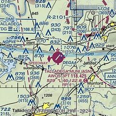
|
| Airport distance calculator |
|---|
|
|
| Sunrise and sunset |
|---|
|
Times for 01-Aug-2026
| | Local
(UTC-5) | | Zulu
(UTC) |
|---|
| Morning civil twilight | | 05:30 | | 10:30 |
| Sunrise | | 05:57 | | 10:57 |
| Sunset | | 19:44 | | 00:44 |
| Evening civil twilight | | 20:11 | | 01:11 |
|
| Current date and time |
|---|
| Zulu (UTC) | 01-Aug-2026 23:28:40 |
|---|
| Local (UTC-5) | 01-Aug-2026 18:28:40 |
|---|
|
| METAR |
|---|
| KASN | 012315Z AUTO 19010KT 6SM -TSDZ BR BKN031 BKN043 OVC065 26/26 A2974 RMK AO2 LTG DSNT ALQDS
|
KPLR
10nm W | 012215Z AUTO 00000G12KT 1/2SM FG BKN004 BKN024 OVC037 27/26 A2976 RMK A01
|
KANB
10nm E | 012311Z AUTO 20005KT 10SM TS FEW033 SCT080 BKN095 28/24 A2975 RMK AO2 LTG DSNT SW AND W RAB2256E10 TSB05 P0000 T02830244
|
|
| NOTAMs |
|---|
NOTAMs are issued by the DoD/FAA and will open in a separate window not controlled by AirNav.
|
|

