FAA INFORMATION EFFECTIVE 09 JULY 2026
Location
| FAA Identifier: | BAC |
| Lat/Long: | 46-56-28.2910N 098-01-04.5520W
46-56.471517N 098-01.075867W
46.9411919,-98.0179311
(estimated) |
| Elevation: | 1401.7 ft. / 427.2 m (surveyed) |
| Variation: | 07E (1985) |
| From city: | 1 mile NW of VALLEY CITY, ND |
| Time zone: | UTC -5 (UTC -6 during Standard Time) |
| Zip code: | 58072 |
Airport Operations
| Airport use: | Open to the public |
| Activation date: | 12/1938 |
| Control tower: | no |
| ARTCC: | MINNEAPOLIS CENTER |
| FSS: | GRAND FORKS FLIGHT SERVICE STATION |
| NOTAMs facility: | GFK (NOTAM-D service available) |
| Attendance: | MON-FRI 0800-1700, ALL SAT-SUN ON CALL
ARPT ATTENDANT AFT HRS CALL 701-840-5903. |
| Wind indicator: | lighted |
| Segmented circle: | yes |
| Lights: | MIRL RWY 13/31 PRESET ON MED INTST; TO INCR INTST AND ACTVT PAPI RWY 13 & 31 - CTAF. |
| Beacon: | white-green (lighted land airport)
Operates sunset to sunrise. |
Airport Communications
| CTAF/UNICOM: | 122.8 |
| WX AWOS-3: | 118.725 (701-845-9117) |
- APCH/DEP SVC PRVDD BY MINNEAPOLIS ARTCC ON FREQS 124.2/270.3 (WOODWORTH RCAG).
Nearby radio navigation aids
| VOR radial/distance | | VOR name | | Freq | | Var |
|---|
| JMSr085/27.1 | | JAMESTOWN VOR/DME | | 114.50 | | 04E |
Airport Services
| Fuel available: | 100LL JET-A
100LL:FUEL AVBL H24 SELF SVC VIA CREDIT CARD.
A:FUEL AVBL H24 SELF SVC VIA CREDIT CARD. |
| Parking: | hangars and tiedowns |
| Airframe service: | MAJOR |
| Powerplant service: | MAJOR |
| Bottled oxygen: | NONE |
| Bulk oxygen: | NONE |
Runway Information
Runway 13/31
| Dimensions: | 4201 x 75 ft. / 1280 x 23 m |
| Surface: | concrete, in good condition |
| Weight bearing capacity: | |
| Runway edge lights: | medium intensity |
| RUNWAY 13 | | RUNWAY 31 |
| Latitude: | 46-56.844045N | | 46-56.363887N |
| Longitude: | 098-01.347717W | | 098-00.622062W |
| Elevation: | 1401.7 ft. | | 1384.9 ft. |
| Traffic pattern: | left | | left |
| Runway heading: | 127 magnetic, 134 true | | 307 magnetic, 314 true |
| Markings: | nonprecision, in good condition | | nonprecision, in good condition |
| Visual slope indicator: | 2-light PAPI on left (3.00 degrees glide path) | | 2-light PAPI on left (3.00 degrees glide path) |
| Runway end identifier lights: | no | | no |
| Touchdown point: | yes, no lights | | yes, no lights |
Runway 17/35
| Dimensions: | 3539 x 100 ft. / 1079 x 30 m |
| Surface: | turf, in good condition |
| RUNWAY 17 | | RUNWAY 35 |
| Latitude: | 46-56.777683N | | 46-56.195618N |
| Longitude: | 098-01.298703W | | 098-01.300212W |
| Elevation: | 1397.0 ft. | | 1380.1 ft. |
| Traffic pattern: | left | | left |
| Runway heading: | 173 magnetic, 180 true | | 353 magnetic, 360 true |
| Runway end identifier lights: | no | | no |
| Touchdown point: | yes, no lights | | yes, no lights |
Runway 5/23
| Dimensions: | 2525 x 120 ft. / 770 x 37 m |
| Surface: | turf, in good condition |
| RUNWAY 5 | | RUNWAY 23 |
| Latitude: | 46-56.215685N | | 46-56.437623N |
| Longitude: | 098-01.272495W | | 098-00.759988W |
| Elevation: | 1379.3 ft. | | 1384.8 ft. |
| Traffic pattern: | left | | left |
| Runway heading: | 051 magnetic, 058 true | | 231 magnetic, 238 true |
| Runway end identifier lights: | no | | no |
| Touchdown point: | yes, no lights | | yes, no lights |
Runway 8/26
| Dimensions: | 2520 x 120 ft. / 768 x 37 m |
| Surface: | turf, in good condition |
| RUNWAY 8 | | RUNWAY 26 |
| Latitude: | 46-56.375308N | | 46-56.373818N |
| Longitude: | 098-01.275925W | | 098-00.670760W |
| Elevation: | 1385.5 ft. | | 1384.2 ft. |
| Traffic pattern: | left | | left |
| Runway heading: | 083 magnetic, 090 true | | 263 magnetic, 270 true |
| Runway end identifier lights: | no | | no |
| Touchdown point: | yes, no lights | | yes, no lights |
Airport Ownership and Management from official FAA records
| Ownership: | Publicly-owned |
| Owner: | BARNES COUNTY AIRPORT AUTHORITY
P.O. BOX 2
VALLEY CITY, ND 58072
Phone 701-840-2029
ARPT AUTH CHAIRPERSON - SHAWN ANDERSON. |
| Manager: | MIKE LERUD
P.O. BOX 2
VALLEY CITY, ND 58072
Phone 701-840-5903 |
Additional Remarks
| A52-35 | +35'PLINE MRKD WITH DALGT BALLS 1000' FM THR APCH RATIO 28:1. |
| - | RWY 05/23, 08/26 & 17/35 CLSD WINTER MONTHS DUE TO LACK OF SNOW REMOVAL |
| - | CONFIRM SNOW REMOVAL & WINTER CONDS NOV-MAR, CALL 701-840-5903. |
| - | BIRDS & DEER ON & INVOF ARPT. |
| - | FOR CD CTC MINNEAPOLIS ARTCC AT 651-463-5588. |
| - | GLD ACT ON & INVOF ARPT. |
Instrument Procedures
NOTE: All procedures below are presented as PDF files. If you need a reader for these files, you should download the free Adobe Reader.NOT FOR NAVIGATION. Please procure official charts for flight.
FAA instrument procedures published for use from 09 July 2026 at 0901Z to 06 August 2026 at 0900Z.
IAPs - Instrument Approach Procedures |
|---|
| RNAV (GPS) RWY 13 | |
download (253KB) |
| RNAV (GPS) RWY 31 | |
download (255KB) |
| NOTE: Special Alternate Minimums apply | |
download (157KB) |
| NOTE: Special Take-Off Minimums/Departure Procedures apply | |
download (356KB) |
Other nearby airports with instrument procedures:
KJMS - Jamestown Regional Airport (27 nm W)
S32 - Cooperstown Municipal Airport (29 nm N)
6L3 - Lisbon Municipal Airport (32 nm S)
5N8 - Casselton Robert Miller Regional Airport (34 nm E)
K74 - Robert Odegaard Field Airport (45 nm E)
|
|

Road maps at:
MapQuest
Bing
Google
| Aerial photo |
|---|
WARNING: Photo may not be current or correct

Do you have a better or more recent aerial photo of Barnes County Municipal Airport that you would like to share? If so, please send us your photo.
|
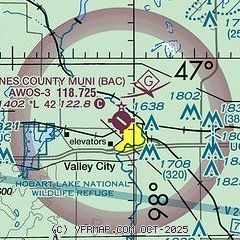
| Sectional chart |
|---|
|
| Airport distance calculator |
|---|
|
|
| Sunrise and sunset |
|---|
|
Times for 03-Aug-2026
| | Local
(UTC-5) | | Zulu
(UTC) |
|---|
| Morning civil twilight | | 05:40 | | 10:40 |
| Sunrise | | 06:15 | | 11:15 |
| Sunset | | 21:01 | | 02:01 |
| Evening civil twilight | | 21:36 | | 02:36 |
|
| Current date and time |
|---|
| Zulu (UTC) | 03-Aug-2026 15:15:20 |
|---|
| Local (UTC-5) | 03-Aug-2026 10:15:20 |
|---|
|
| METAR |
|---|
| KBAC | 031455Z AUTO 05020G26KT 3SM VCTS RA BR BKN023 OVC027 18/18 A2975 RMK AO2 LTG DSNT NE
|
|
| TAF |
|---|
KJMS
27nm W | 031150Z 0312/0412 VRB05KT 6SM -SHRA VCTS SCT040 OVC200CB TEMPO 0312/0316 VRB15G30KT 4SM -TSRA OVC040CB FM031600 10010KT P6SM SCT050 BKN200 PROB30 0316/0319 6SM -RA OVC050 FM031900 02013G22KT P6SM SCT040 BKN070 PROB30 0319/0322 6SM -RA OVC040 FM032200 35020G30KT P6SM BKN080 PROB30 0322/0402 4SM -TSRA OVC040CB FM040300 34015KT P6SM SCT045 BKN100 FM040600 31010KT P6SM SCT050 BKN100
|
|
| NOTAMs |
|---|
NOTAMs are issued by the DoD/FAA and will open in a separate window not controlled by AirNav.
|
|

