FAA INFORMATION EFFECTIVE 09 JULY 2026
Location
| FAA Identifier: | BFW |
| Lat/Long: | 47-14-56.5000N 091-24-56.1000W
47-14.941667N 091-24.935000W
47.2490278,-91.4155833
(estimated) |
| Elevation: | 1088.6 ft. / 331.8 m (surveyed) |
| Variation: | 00E (1995) |
| From city: | 7 miles SW of SILVER BAY, MN |
| Time zone: | UTC -5 (UTC -6 during Standard Time) |
| Zip code: | 55614 |
Airport Operations
| Airport use: | CLOSED PERMANENTLY |
| Activation date: | 02/1965 |
| Control tower: | no |
| ARTCC: | MINNEAPOLIS CENTER |
| FSS: | PRINCETON FLIGHT SERVICE STATION |
| NOTAMs facility: | BFW (NOTAM-D service available) |
| Attendance: | UNATNDD |
| Wind indicator: | lighted |
| Segmented circle: | no |
| Lights: | ACTVT REIL RWY 07 & 25; PAPI RWY 07 & 25; MIRL RWY 07/25 - CTAF. |
| Beacon: | white-green (lighted land airport)
Operates sunset to sunrise. |
Airport Communications
| CTAF: | 122.9 |
| WX AWOS-3PT at TWM (18 nm SW): | 119.325 (218-834-6591) |
- APCH/DEP SVC PRVDD BY MINNEAPOLIS ARTCC ON FREQS 134.55/290.5 (DULUTH RCAG).
Airport Services
| Parking: | hangars and tiedowns |
| Airframe service: | NONE |
| Powerplant service: | NONE |
| Bottled oxygen: | NONE |
| Bulk oxygen: | NONE |
Runway Information
Runway 7/25
| Dimensions: | 3200 x 75 ft. / 975 x 23 m |
| Surface: | asphalt, in poor condition |
| Weight bearing capacity: | |
| Runway edge lights: | medium intensity |
| Operational restrictions: | RWY CLSD DUE TO EDGES CONTAIN LOOSE ROCKS AND CRUMBLING; LRG WDSPR CRACKS; VEGETATION GROWING THRU CRACKS AND JOINTS; MARKINGS FADED. |
| RUNWAY 7 | | RUNWAY 25 |
| Latitude: | 47-14.859000N | | 47-15.018500N |
| Longitude: | 091-25.299333W | | 091-24.562167W |
| Elevation: | 1088.6 ft. | | 1082.9 ft. |
| Traffic pattern: | left | | left |
| Runway heading: | 072 | | 252 |
| Markings: | nonprecision, in fair condition | | nonprecision, in fair condition |
| Visual slope indicator: | 4-light PAPI on left | | 4-light PAPI on left (3.00 degrees glide path) |
| Runway end identifier lights: | yes | | yes |
| Touchdown point: | yes, no lights | | yes, no lights |
| Obstructions: | 44 ft. trees, 979 ft. from runway, 185 ft. right of centerline, 17:1 slope to clear | | 33 ft. trees, 918 ft. from runway, 297 ft. left of centerline, 21:1 slope to clear |
Airport Ownership and Management from official FAA records
| Ownership: | Publicly-owned |
| Owner: | CITY OF SILVER BAY
7 DAVIS DR
SILVER BAY, MN 55614-1397
Phone 218-226-4408 |
| Manager: | LANA FRALICH/JAMES LARSON
CITY ADMINISTRATOR, 7 DAVIS DR
SILVER BAY, MN 55614-1397
Phone 218-226-4408
OR 218-220-1700. |
Additional Remarks
| - | ULTRALIGHT TRAFFIC ON & INVOF ARPT. |
| - | DEER AND WILDLIFE ON & INVOF ARPT. |
| - | NEW TRML BUILDING AVBL, FOR KEYPAD ENTRY PRESS 2, 4 TOGETHER AND THEN PRESS 3. |
| - | POT HOLES ON APN AND TIEDOWN AREA. |
| - | FOR CD CTC MINNEAPOLIS ARTCC AT 651-463-5588. |
| - | (ARPT STATUS) ARPT CLSD PERMLY. |
Instrument Procedures
There are no published instrument procedures at KBFW.
Some nearby airports with instrument procedures:
KTWM - Richard B Helgeson Airport (18 nm SW)
KELO - Ely Municipal Airport (38 nm NW)
4R5 - Major Gilbert Field Airport (39 nm SE)
KDLH - Duluth International Airport (40 nm SW)
KDYT - Sky Harbor Airport (41 nm SW)
|
|

Road maps at:
MapQuest
Bing
Google
| Aerial photo |
|---|
WARNING: Photo may not be current or correct
 Photo by Tim Flynn
Do you have a better or more recent aerial photo of Silver Bay Municipal Airport that you would like to share? If so, please send us your photo.
|
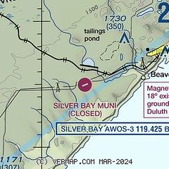
| Sectional chart |
|---|
|
| Airport distance calculator |
|---|
|
|
| Sunrise and sunset |
|---|
|
Times for 01-Aug-2026
| | Local
(UTC-5) | | Zulu
(UTC) |
|---|
| Morning civil twilight | | 05:10 | | 10:10 |
| Sunrise | | 05:45 | | 10:45 |
| Sunset | | 20:39 | | 01:39 |
| Evening civil twilight | | 21:14 | | 02:14 |
|
| Current date and time |
|---|
| Zulu (UTC) | 01-Aug-2026 08:45:13 |
|---|
| Local (UTC-5) | 01-Aug-2026 03:45:13 |
|---|
|
| METAR |
|---|
KTWM
19nm SW | 010835Z AUTO 34004KT 10SM CLR 18/13 A2996 RMK AO2
|
|
| TAF |
|---|
KDLH
40nm SW | 010525Z 0106/0206 VRB06KT P6SM BKN210 FM011700 06007KT P6SM FEW035
|
|
| NOTAMs |
|---|
NOTAMs are issued by the DoD/FAA and will open in a separate window not controlled by AirNav.
|
|

