FAA INFORMATION EFFECTIVE 16 APRIL 2026
Location
| FAA Identifier: | TWM |
| Lat/Long: | 47-02-56.9000N 091-44-42.8000W
47-02.948333N 091-44.713333W
47.0491389,-91.7452222
(estimated) |
| Elevation: | 1073.1 ft. / 327.1 m (surveyed) |
| Variation: | 01E (1990) |
| From city: | 4 miles NW of TWO HARBORS, MN |
| Time zone: | UTC -5 (UTC -6 during Standard Time) |
| Zip code: | 55616 |
Airport Operations
| Airport use: | Open to the public |
| Activation date: | 01/1970 |
| Control tower: | no |
| ARTCC: | MINNEAPOLIS CENTER |
| FSS: | PRINCETON FLIGHT SERVICE STATION |
| NOTAMs facility: | TWM (NOTAM-D service available) |
| Attendance: | MON-FRI 0800-1400
FOR SVC AFT HRS CALL (218) 830-0470 |
| Wind indicator: | lighted |
| Segmented circle: | yes |
| Lights: | MIRL RWY 6/24 PRESET TO LOW SS-SR. INCR INTST AND ACTVT REIL RWY 06, 24; PAPI RWY 6, 24 - CTAF. |
| Beacon: | white-green (lighted land airport)
Operates sunset to sunrise. |
Airport Communications
| CTAF: | 122.9 |
| WX AWOS-3PT: | 119.325 (218-834-6591) |
| DULUTH APPROACH: | 125.45 |
| DULUTH DEPARTURE: | 125.45 |
Nearby radio navigation aids
| VOR radial/distance | | VOR name | | Freq | | Var |
|---|
| DLHr047/23.9 | | DULUTH VORTAC | | 112.60 | | 05E |
Airport Services
| Fuel available: | 100LL JET-A MOGAS
100LL:FUEL AVBL 24 HRS WITH CREDIT CARD. |
| Parking: | hangars and tiedowns |
| Airframe service: | MAJOR |
| Powerplant service: | MINOR |
| Bottled oxygen: | NONE |
| Bulk oxygen: | NONE |
Runway Information
Runway 6/24
| Dimensions: | 4400 x 75 ft. / 1341 x 23 m |
| Surface: | asphalt, in good condition |
| Runway edge lights: | medium intensity |
| RUNWAY 6 | | RUNWAY 24 |
| Latitude: | 47-02.838293N | | 47-03.175442N |
| Longitude: | 091-45.185775W | | 091-44.248832W |
| Elevation: | 1073.1 ft. | | 1070.0 ft. |
| Traffic pattern: | left | | left |
| Runway heading: | 061 magnetic, 062 true | | 241 magnetic, 242 true |
| Markings: | nonprecision, in fair condition | | nonprecision, in fair condition |
| Visual slope indicator: | 4-light PAPI on left (3.00 degrees glide path) | | 4-light PAPI on left (3.00 degrees glide path) |
| Runway end identifier lights: | yes | | yes |
| Touchdown point: | yes, no lights | | yes, no lights |
Runway 15/33
| Dimensions: | 2581 x 150 ft. / 787 x 46 m |
| Surface: | turf, in good condition |
| Runway edge markings: | RY 15/33 MKD WITH YELLOW CONES. |
| Operational restrictions: | CLSD WINTER MONTHS EXCEPT SKI EQUIPPED ACFT. |
| RUNWAY 15 | | RUNWAY 33 |
| Latitude: | 47-03.028665N | | 47-02.666638N |
| Longitude: | 091-44.869627W | | 091-44.545183W |
| Elevation: | 1072.3 ft. | | 1040.0 ft. |
| Traffic pattern: | left | | left |
| Runway heading: | 148 magnetic, 149 true | | 328 magnetic, 329 true |
| Touchdown point: | yes, no lights | | yes, no lights |
| Obstructions: | none | | 9 ft. trees, 113 ft. from runway, 99 ft. left of centerline, 12:1 slope to clear |
Airport Ownership and Management from official FAA records
| Ownership: | Publicly-owned |
| Owner: | CITY OF TWO HARBORS
CITY HALL, 522 1ST AVE
TWO HARBORS, MN 55616-1535
Phone 218-834-5631 |
| Manager: | CASEY KOMAREK
522 1ST AVE
TWO HARBORS, MN 55616-1535
Phone 218-510-0628 |
Additional Remarks
| - | GCO AVBL ON FREQ 121.725 THRU DLH CD & FLT SVCS. |
| - | FOR CD CTC DULUTH APCH AT 218-740-5950. |
Instrument Procedures
NOTE: All procedures below are presented as PDF files. If you need a reader for these files, you should download the free Adobe Reader.NOT FOR NAVIGATION. Please procure official charts for flight.
FAA instrument procedures published for use from 16 April 2026 at 0901Z to 14 May 2026 at 0900Z.
IAPs - Instrument Approach Procedures |
|---|
| RNAV (GPS) RWY 06 | |
download (208KB) |
| RNAV (GPS) RWY 24 | |
download (244KB) |
| NOTE: Special Alternate Minimums apply | |
download (25KB) |
| NOTE: Special Take-Off Minimums/Departure Procedures apply | |
download (156KB) |
Other nearby airports with instrument procedures:
KDLH - Duluth International Airport (22 nm SW)
KDYT - Sky Harbor Airport (23 nm SW)
KSUW - Richard I Bong Airport (26 nm SW)
KCOQ - Cloquet/Carlton County Airport (37 nm SW)
KEVM - Eveleth/Virginia Municipal Airport (38 nm NW)
|
|

Road maps at:
MapQuest
Bing
Google
| Aerial photo |
|---|
WARNING: Photo may not be current or correct
 Photo by R.B.Johnson
Do you have a better or more recent aerial photo of Richard B Helgeson Airport that you would like to share? If so, please send us your photo.
|
| Sectional chart |
|---|
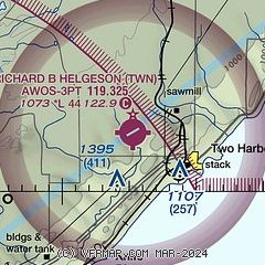
|
| Airport distance calculator |
|---|
|
|
| Sunrise and sunset |
|---|
|
Times for 08-May-2026
| | Local
(UTC-5) | | Zulu
(UTC) |
|---|
| Morning civil twilight | | 05:07 | | 10:07 |
| Sunrise | | 05:42 | | 10:42 |
| Sunset | | 20:25 | | 01:25 |
| Evening civil twilight | | 21:00 | | 02:00 |
|
| Current date and time |
|---|
| Zulu (UTC) | 09-May-2026 03:56:33 |
|---|
| Local (UTC-5) | 08-May-2026 22:56:33 |
|---|
|
| METAR |
|---|
| KTWM | 090335Z AUTO 33003KT 10SM SCT080 09/M04 A2954 RMK AO2
|
|
| TAF |
|---|
KDLH
22nm SW | 082043Z 0821/0918 25009G19KT P6SM BKN100 BKN120 FM090100 32007KT P6SM BKN100 FM091500 33013G21KT P6SM SCT050
|
|
| NOTAMs |
|---|
NOTAMs are issued by the DoD/FAA and will open in a separate window not controlled by AirNav.
|
|

