FAA INFORMATION EFFECTIVE 16 APRIL 2026
Location
| FAA Identifier: | BNO |
| Lat/Long: | 43-35-30.8600N 118-57-19.5740W
43-35.514333N 118-57.326233W
43.5919056,-118.9554372
(estimated) |
| Elevation: | 4148.2 ft. / 1264.4 m (surveyed) |
| Variation: | 18E (1980) |
| From city: | 5 miles E of BURNS, OR |
| Time zone: | UTC -7 (UTC -8 during Standard Time) |
| Zip code: | 97720 |
Airport Operations
| Airport use: | Open to the public |
| Activation date: | 06/1943 |
| Control tower: | no |
| ARTCC: | SALT LAKE CITY CENTER |
| FSS: | MC MINNVILLE FLIGHT SERVICE STATION |
| NOTAMs facility: | BNO (NOTAM-D service available) |
| Attendance: | UNATNDD |
| Wind indicator: | lighted |
| Segmented circle: | yes |
| Lights: | ACTVT MIRL RYS 03/21 & 12/30, PAPI RYS 03 & 21, VASI RYS 12 & 30, & REILS RYS 03, 21, 12, & 30 - CTAF. |
| Beacon: | white-green (lighted land airport)
Operates sunset to sunrise. |
Airport Communications
| CTAF/UNICOM: | 122.8 |
| WX ASOS: | 135.575 (541-573-1382) |
- COMMUNICATIONS PRVDD BY MC MINNVILLE RADIO ON FREQ 122.5 (BURNS RCO).
- APCH/DEP CTL SVC PRVDD BY SALT LAKE ARTCC (ZLC) ON 128.05/306.95 (BAKER RCAG).
Nearby radio navigation aids
| VOR radial/distance | | VOR name | | Freq | | Var |
|---|
| ILR at field | | WILDHORSE VOR/DME | | 114.55 | | 18E |
Airport Services
| Fuel available: | 100LL JET-A |
| Parking: | hangars and tiedowns |
| Airframe service: | NONE |
| Powerplant service: | NONE |
| Bottled oxygen: | NONE |
| Bulk oxygen: | NONE |
Runway Information
Runway 12/30
| Dimensions: | 5101 x 75 ft. / 1555 x 23 m |
| Surface: | concrete, in good condition |
| Weight bearing capacity: | | Single wheel: | 30.0 | | Double wheel: | 50.0 | | Double tandem: | 90.0 |
|
| Runway edge lights: | medium intensity |
| RUNWAY 12 | | RUNWAY 30 |
| Latitude: | 43-35.818550N | | 43-35.230060N |
| Longitude: | 118-57.852765W | | 118-57.029120W |
| Elevation: | 4147.7 ft. | | 4144.3 ft. |
| Traffic pattern: | left | | left |
| Runway heading: | 117 magnetic, 135 true | | 297 magnetic, 315 true |
| Markings: | basic, in good condition | | nonprecision, in good condition |
| Visual slope indicator: | 2-box VASI on left (3.00 degrees glide path) | | 2-box VASI on left (3.00 degrees glide path) |
| Runway end identifier lights: | yes | | yes |
| Touchdown point: | yes, no lights | | yes, no lights |
| Obstructions: | none | | 14 ft. road, 900 ft. from runway, 205 ft. left of centerline |
Runway 3/21
| Dimensions: | 4600 x 60 ft. / 1402 x 18 m |
| Surface: | concrete, in good condition |
| Weight bearing capacity: | |
| Runway edge lights: | medium intensity |
| RUNWAY 3 | | RUNWAY 21 |
| Latitude: | 43-35.247905N | | 43-35.759162N |
| Longitude: | 118-57.583105W | | 118-56.814982W |
| Elevation: | 4146.2 ft. | | 4143.7 ft. |
| Traffic pattern: | left | | left |
| Runway heading: | 030 magnetic, 048 true | | 210 magnetic, 228 true |
| Displaced threshold: | 600 ft. | | no |
| Markings: | basic, in good condition | | basic, in good condition |
| Visual slope indicator: | 2-light PAPI on left (3.00 degrees glide path) | | 2-light PAPI on left (3.00 degrees glide path) |
| Runway end identifier lights: | yes | | yes |
| Touchdown point: | yes, no lights | | yes, no lights |
| Obstructions: | 32 ft. pline, lighted, 900 ft. from runway, 21:1 slope to clear
RWY 03 APRCH RATIO 50:1 TO DSPLCD THR. | | none |
Airport Ownership and Management from official FAA records
| Ownership: | Publicly-owned |
| Owner: | CITY OF BURNS
242 S. BROADWAY
BURNS, OR 97720
Phone 541-573-5255 |
| Manager: | SCOTT WILLIAMSON
70346 TERMINAL WAY
BURNS, OR 97720
Phone 541-480-3854 |
Additional Remarks
| - | FLOCKS OF LARGE BIRDS INVOF ARPT FEB - MAY & SEP - OCT. |
| - | FOR CD IF UNA TO CTC ON FSS FREQ, CTC SALT LAKE ARTCC AT 801-320-2568. |
Instrument Procedures
NOTE: All procedures below are presented as PDF files. If you need a reader for these files, you should download the free Adobe Reader.NOT FOR NAVIGATION. Please procure official charts for flight.
FAA instrument procedures published for use from 16 April 2026 at 0901Z to 14 May 2026 at 0900Z.
IAPs - Instrument Approach Procedures |
|---|
| RNAV (GPS) RWY 30 | |
download (199KB) |
| VOR RWY 30 | |
download (158KB) |
| NOTE: Special Alternate Minimums apply | |
download (26KB) |
| NOTE: Special Take-Off Minimums/Departure Procedures apply | |
download (223KB) |
Other nearby airports with instrument procedures:
KGCD - Grant County Regional Airport/Ogilvie Field (49 nm N)
62S - Christmas Valley Airport (77 nm W)
KONO - Ontario Municipal Airport (88 nm E)
KBKE - Baker City Municipal Airport (90 nm NE)
S87 - Weiser Municipal Airport (94 nm NE)
|
|

Road maps at:
MapQuest
Bing
Google
| Aerial photo |
|---|
WARNING: Photo may not be current or correct
 Photo taken 24-May-2014
looking northeast.
Photo taken 24-May-2014
looking northeast.
Do you have a better or more recent aerial photo of Burns Municipal Airport that you would like to share? If so, please send us your photo.
|
| Sectional chart |
|---|
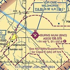
|
| Airport distance calculator |
|---|
|
|
| Sunrise and sunset |
|---|
|
Times for 10-May-2026
| | Local
(UTC-7) | | Zulu
(UTC) |
|---|
| Morning civil twilight | | 05:05 | | 12:05 |
| Sunrise | | 05:37 | | 12:37 |
| Sunset | | 20:07 | | 03:07 |
| Evening civil twilight | | 20:40 | | 03:40 |
|
| Current date and time |
|---|
| Zulu (UTC) | 11-May-2026 00:28:54 |
|---|
| Local (UTC-7) | 10-May-2026 17:28:54 |
|---|
|
| METAR |
|---|
| KBNO | 102353Z AUTO 32009KT 10SM CLR 26/03 A2996 RMK AO2 SLP129 T02560028 10294 20233 56009
|
|
| TAF |
|---|
| KBNO | 101720Z 1018/1118 18008KT P6SM SCT200 FM102000 23011G22KT P6SM SCT200 FM110100 30013G22KT P6SM BKN150 FM110600 27007KT P6SM SCT150
|
|
| NOTAMs |
|---|
NOTAMs are issued by the DoD/FAA and will open in a separate window not controlled by AirNav.
|
|


