FAA INFORMATION EFFECTIVE 16 APRIL 2026
Location
| FAA Identifier: | CIC |
| Lat/Long: | 39-47-43.4000N 121-51-30.3000W
39-47.723333N 121-51.505000W
39.7953889,-121.8584167
(estimated) |
| Elevation: | 240.2 ft. / 73.2 m (surveyed) |
| Variation: | 16E (1990) |
| From city: | 4 miles N of CHICO, CA |
| Time zone: | UTC -7 (UTC -8 during Standard Time) |
| Zip code: | 95973 |
Airport Operations
| Airport use: | Open to the public |
| Activation date: | 04/1987 |
| Control tower: | yes |
| ARTCC: | OAKLAND CENTER |
| FSS: | RANCHO MURIETA FLIGHT SERVICE STATION |
| NOTAMs facility: | CIC (NOTAM-D service available) |
| Attendance: | 0700-1900 |
| Wind indicator: | lighted |
| Segmented circle: | yes |
| Lights: | WHEN ATCT CLSD ACTVT MALSR RWY 13L; REIL RWY 31R; PAPI RWY 13L; VASI RWY 31R; HIRL RWY 13L/31R - CTAF. |
| Beacon: | white-green (lighted land airport)
Operates sunset to sunrise. |
| Fire and rescue: | ARFF index A |
| Airline operations: | PPR FOR SKEDD ACR SER INVOLVING ACFT WITH MORE THAN 9 PAX SEATS AND UNSKEDD ACR SER INVOLVING ACFT WITH MORE THAN 30 PAX SEATS. WITHOUT PPR, ARFF SERS MAY NOT BE AVBL. FOR PPR CTC AMGR, 530-896-7216. |
Airport Communications
| CTAF: | 121.0 |
| UNICOM: | 122.95 |
| ATIS: | 119.675 |
| WX AWOS-3: | 119.675 (530-879-3850) |
| CHICO GROUND: | 121.9 [0700-1900] |
| CHICO TOWER: | 121.0 239.3 [0700-1900] |
- APCH/DEP CTL SVC PRVDD BY OAKLAND ARTCC (ZOA) ON FREQS 132.2/350.3 (RED BLUFF RCAG).
- EMERG FREQ 121.5 NOT AVBL.
Nearby radio navigation aids
| VOR radial/distance | | VOR name | | Freq | | Var |
|---|
| RBLr118/25.2 | | RED BLUFF VORTAC | | 115.70 | | 18E |
Airport Services
| Fuel available: | 100LL JET-A
100LL:FOR FUEL AFT HRS CALL (530) 588-4888 |
| Parking: | tiedowns |
| Airframe service: | MAJOR |
| Powerplant service: | MAJOR |
| Bottled oxygen: | HIGH |
Runway Information
Runway 13L/31R
| Dimensions: | 6724 x 150 ft. / 2049 x 46 m |
| Surface: | asphalt/grooved, in good condition |
| Weight bearing capacity: | | PCN 20 /F/B/X/T | | Single wheel: | 63.0 | | Double wheel: | 100.0 | | Double tandem: | 170.0 |
|
| Runway edge lights: | high intensity |
| RUNWAY 13L | | RUNWAY 31R |
| Latitude: | 39-48.202917N | | 39-47.269633N |
| Longitude: | 121-51.847150W | | 121-51.074200W |
| Elevation: | 240.2 ft. | | 207.2 ft. |
| Traffic pattern: | right | | left |
| Runway heading: | 131 magnetic, 147 true | | 311 magnetic, 327 true |
| Declared distances: | TORA:6724 TODA:6724 ASDA:6724 LDA:6724 | | TORA:6724 TODA:6724 ASDA:6724 LDA:6724 |
| Markings: | precision, in good condition | | precision, in good condition |
| Visual slope indicator: | 4-light PAPI on left (3.00 degrees glide path) | | 4-box VASI on left (3.00 degrees glide path) |
| Approach lights: | MALSR: 1,400 foot medium intensity approach lighting system with runway alignment indicator lights | | |
| Runway end identifier lights: | no | | yes |
| Touchdown point: | yes, no lights | | yes, no lights |
| Instrument approach: | ILS/DME | | |
Runway 13R/31L
| Dimensions: | 3000 x 60 ft. / 914 x 18 m |
| Surface: | asphalt, in fair condition |
| Weight bearing capacity: | | PCN 9 /F/C/Y/T | | Single wheel: | 12.5 |
|
| RUNWAY 13R | | RUNWAY 31L |
| Latitude: | 39-47.903270N | | 39-47.486772N |
| Longitude: | 121-51.776143W | | 121-51.431445W |
| Elevation: | 226.9 ft. | | 215.0 ft. |
| Traffic pattern: | right | | left |
| Runway heading: | 131 magnetic, 147 true | | 311 magnetic, 327 true |
| Declared distances: | TORA:3000 TODA:3000 ASDA:3000 LDA:3000 | | TORA:3000 TODA:3000 ASDA:3000 LDA:3000 |
| Markings: | basic, in fair condition | | basic, in fair condition |
| Runway end identifier lights: | no | | no |
| Touchdown point: | yes, no lights | | yes, no lights |
Helipad H1
| Dimensions: | 64 x 64 ft. / 20 x 20 m |
| Surface: | concrete, in good condition |
| Weight bearing capacity: | |
| Latitude: | 39-47.800333N | | |
| Longitude: | 121-51.291000W | | |
| Elevation: | 234.0 ft. | | |
| Traffic pattern: | left | | left |
Airport Ownership and Management from official FAA records
| Ownership: | Publicly-owned |
| Owner: | CITY OF CHICO
PO BOX 3420
CHICO, CA 95927
Phone 530-896-7200 |
| Manager: | TOM BAHR
150 AIRPARK BLVD., SUITE 110
CHICO, CA 95973
Phone 530-896-7216 |
Additional Remarks
| - | FOR JET/HVY ACFT OPER EAST OF FLD TPA 1500 FT AGL; FOR LGT ACFT OPER WEST & EAST OF FLD TPA 1000 FT AGL. |
| - | BIRDS ON AND IN VCNTY OF ARPT. |
| - | FUEL AVBL 0730-1900. FOR AFTER HRS FUEL CALL 530-588-4888. |
Instrument Procedures
NOTE: All procedures below are presented as PDF files. If you need a reader for these files, you should download the free Adobe Reader.NOT FOR NAVIGATION. Please procure official charts for flight.
FAA instrument procedures published for use from 16 April 2026 at 0901Z to 14 May 2026 at 0900Z.
IAPs - Instrument Approach Procedures |
|---|
| ILS OR LOC RWY 13L | |
download (332KB) |
| RNAV (GPS) RWY 13L | |
download (313KB) |
| RNAV (GPS) RWY 31R | |
download (283KB) |
| NOTE: Special Alternate Minimums apply | |
download (137KB) |
Departure Procedures |
|---|
| CHICO FIVE | |
download (217KB) |
| NOTE: Special Take-Off Minimums/Departure Procedures apply | |
download (351KB) |
Other nearby airports with instrument procedures:
O37 - Haigh Field Airport (14 nm W)
KOVE - Oroville Municipal Airport (21 nm SE)
KWLW - Willows/Glenn County Airport (24 nm SW)
KRBL - Red Bluff Municipal Airport (28 nm NW)
O08 - Colusa County Airport (38 nm S)
|
|

Road maps at:
MapQuest
Bing
Google
| Aerial photo |
|---|
WARNING: Photo may not be current or correct
 Taken in January 2007
Do you have a better or more recent aerial photo of Chico Regional Airport that you would like to share? If so, please send us your photo.
|
| Sectional chart |
|---|
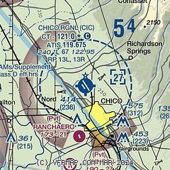
|
 Download PDF
of official airport diagram from the FAA
| Airport distance calculator |
|---|
|
|
| Sunrise and sunset |
|---|
|
Times for 08-May-2026
| | Local
(UTC-7) | | Zulu
(UTC) |
|---|
| Morning civil twilight | | 05:31 | | 12:31 |
| Sunrise | | 06:01 | | 13:01 |
| Sunset | | 20:07 | | 03:07 |
| Evening civil twilight | | 20:37 | | 03:37 |
|
| Current date and time |
|---|
| Zulu (UTC) | 09-May-2026 01:19:03 |
|---|
| Local (UTC-7) | 08-May-2026 18:19:03 |
|---|
|
| METAR |
|---|
| KCIC | 082252Z 26007KT 10SM CLR 29/16 A2997
|
|
| TAF |
|---|
KRBL
28nm NW | 081729Z 0818/0918 VRB03KT P6SM FEW250 FM081900 16007KT P6SM SKC FM090600 33006KT P6SM SKC
|
|
| NOTAMs |
|---|
NOTAMs are issued by the DoD/FAA and will open in a separate window not controlled by AirNav.
|
|


