FAA INFORMATION EFFECTIVE 14 MAY 2026
Location
| FAA Identifier: | WLW |
| Lat/Long: | 39-30-56.7212N 122-13-02.1916W
39-30.945353N 122-13.036527W
39.5157559,-122.2172754
(estimated) |
| Elevation: | 141.2 ft. / 43.0 m (surveyed) |
| Variation: | 14E (2020) |
| From city: | 1 mile W of WILLOWS, CA |
| Time zone: | UTC -7 (UTC -8 during Standard Time) |
| Zip code: | 95988 |
Airport Operations
| Airport use: | Open to the public |
| Activation date: | 04/1940 |
| Control tower: | no |
| ARTCC: | OAKLAND CENTER |
| FSS: | RANCHO MURIETA FLIGHT SERVICE STATION |
| NOTAMs facility: | RIU (NOTAM-D service available) |
| Attendance: | 0730-1530 |
| Wind indicator: | lighted |
| Segmented circle: | yes |
| Lights: | ACTVT MIRL RY 16/34 & VASI RY 34 - CTAF. |
| Beacon: | white-green (lighted land airport)
Operates sunset to sunrise. |
Airport Communications
- APCH/DEP CTL SVC PRVDD BY OAKLAND ARTCC (ZOA) ON FREQS 132.2/350.3 (RED BLUFF RCAG).
Nearby radio navigation aids
| VOR radial/distance | | VOR name | | Freq | | Var |
|---|
| ILAr324/28.1 | | WILLIAMS VORTAC | | 114.40 | | 18E |
| RBLr161/35.0 | | RED BLUFF VORTAC | | 115.70 | | 18E |
| MYVr294/39.0 | | MARYSVILLE VOR/DME | | 110.80 | | 16E |
Airport Services
| Fuel available: | 100LL
100LL:24HR CARD LOCK |
| Parking: | tiedowns |
| Bottled oxygen: | NONE |
| Bulk oxygen: | NONE |
Runway Information
Runway 16/34
| Dimensions: | 4125 x 100 ft. / 1257 x 30 m |
| Surface: | asphalt, in good condition |
| Weight bearing capacity: | | Single wheel: | 38.0 | | Double wheel: | 53.0 |
|
| Runway edge lights: | medium intensity |
| RUNWAY 16 | | RUNWAY 34 |
| Latitude: | 39-31.297078N | | 39-30.617973N |
| Longitude: | 122-13.196330W | | 122-13.168878W |
| Elevation: | 141.2 ft. | | 136.2 ft. |
| Traffic pattern: | right | | left |
| Runway heading: | 164 magnetic, 178 true | | 344 magnetic, 358 true |
| Markings: | basic, in good condition | | nonprecision, in good condition |
| Visual slope indicator: | | | 4-box VASI on left (3.00 degrees glide path) |
| Runway end identifier lights: | no | | |
| Touchdown point: | yes, no lights | | yes, no lights |
| Obstructions: | 15 ft. road, 550 ft. from runway, 23:1 slope to clear | | none |
Runway 13/31
| Dimensions: | 3788 x 60 ft. / 1155 x 18 m |
| Surface: | asphalt, in fair condition |
| Weight bearing capacity: | |
| RUNWAY 13 | | RUNWAY 31 |
| Latitude: | 39-31.187660N | | 39-30.676538N |
| Longitude: | 122-13.108402W | | 122-12.646507W |
| Elevation: | 137.7 ft. | | 131.3 ft. |
| Traffic pattern: | right | | left |
| Runway heading: | 131 magnetic, 145 true | | 311 magnetic, 325 true |
| Displaced threshold: | no | | 243 ft. |
| Markings: | basic, in good condition | | basic, in good condition |
| Runway end identifier lights: | no | | no |
| Touchdown point: | yes, no lights | | yes, no lights |
| Obstructions: | 50 ft. trees, 1910 ft. from runway, 100 ft. right of centerline, 34:1 slope to clear | | none |
Airport Ownership and Management from official FAA records
| Ownership: | Publicly-owned |
| Owner: | COUNTY OF GLENN
525 W SYCAMORE ST., STE B1
WILLOWS, CA 95988
Phone 530-934-6400 |
| Manager: | TALIA RICHARDSON
777 NORTH COLUSA STREET
WILLOWS, CA 95988
Phone 530-934-6530
PUBLIC WORKS DIRECTOR. |
Additional Remarks
| - | FOR CD CTC OAKLAND ARTCC AT 510-745-3380. |
Instrument Procedures
NOTE: All procedures below are presented as PDF files. If you need a reader for these files, you should download the free Adobe Reader.NOT FOR NAVIGATION. Please procure official charts for flight.
FAA instrument procedures published for use from 14 May 2026 at 0901Z to 11 June 2026 at 0900Z.
IAPs - Instrument Approach Procedures |
|---|
| RNAV (GPS) RWY 34 | |
download (197KB) |
| VOR RWY 34 | |
download (175KB) |
| VOR RWY 34 | |
download (175KB) |
| NOTE: Special Take-Off Minimums/Departure Procedures apply | |
download (347KB) |
Other nearby airports with instrument procedures:
O37 - Haigh Field Airport (13 nm N)
O08 - Colusa County Airport (23 nm SE)
KCIC - Chico Regional Airport (24 nm NE)
KOVE - Oroville Municipal Airport (28 nm E)
KRBL - Red Bluff Municipal Airport (38 nm N)
|
|

Road maps at:
MapQuest
Bing
Google
| Aerial photo |
|---|
WARNING: Photo may not be current or correct
 Photo Jassen Photography
Photo taken 06-Nov-2015
looking west.
Photo Jassen Photography
Photo taken 06-Nov-2015
looking west.
Do you have a better or more recent aerial photo of Willows/Glenn County Airport that you would like to share? If so, please send us your photo.
|
| Sectional chart |
|---|
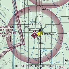
|
| Airport distance calculator |
|---|
|
|
| Sunrise and sunset |
|---|
|
Times for 25-May-2026
| | Local
(UTC-7) | | Zulu
(UTC) |
|---|
| Morning civil twilight | | 05:17 | | 12:17 |
| Sunrise | | 05:48 | | 12:48 |
| Sunset | | 20:24 | | 03:24 |
| Evening civil twilight | | 20:55 | | 03:55 |
|
| Current date and time |
|---|
| Zulu (UTC) | 25-May-2026 22:38:39 |
|---|
| Local (UTC-7) | 25-May-2026 15:38:39 |
|---|
|
| METAR |
|---|
KCIC
24nm NE | 252150Z 14018KT 10SM CLR 25/10 A2981
|
KOVE
28nm E | 252221Z AUTO 17018G25KT 7SM FEW003 25/10 A2982 RMK AO2 T02500100
|
KRBL
38nm N | 252154Z AUTO 16018G26KT 10SM CLR 26/12 A2977 RMK AO2 PK WND 16026/2152 SLP079 T02560122 $
|
KMYV
39nm SE | 252153Z AUTO 15014G22KT 10SM CLR 24/10 A2984 RMK AO2 SLP106 T02440100
|
KBAB
43nm SE | 252155Z AUTO 17015KT 10SM CLR 27/09 A2983 RMK AO2 SLP104 T02650089 $
|
|
| TAF |
|---|
KRBL
38nm N | 252053Z 2521/2618 17014G20KT P6SM FEW250 FM260200 23010KT P6SM SCT250 FM260900 VRB05KT P6SM BKN150
|
|
| NOTAMs |
|---|
NOTAMs are issued by the DoD/FAA and will open in a separate window not controlled by AirNav.
|
|

