FAA INFORMATION EFFECTIVE 14 MAY 2026
Location
| FAA Identifier: | CLI |
| Lat/Long: | 44-36-47.4000N 088-43-51.2000W
44-36.790000N 088-43.853333W
44.6131667,-88.7308889
(estimated) |
| Elevation: | 825.9 ft. / 251.7 m (surveyed) |
| Variation: | 02W (1995) |
| From city: | 1 mile SE of CLINTONVILLE, WI |
| Time zone: | UTC -5 (UTC -6 during Standard Time) |
| Zip code: | 54929 |
Airport Operations
| Airport use: | Open to the public |
| Activation date: | 02/1940 |
| Control tower: | no |
| ARTCC: | MINNEAPOLIS CENTER |
| FSS: | GREEN BAY FLIGHT SERVICE STATION |
| NOTAMs facility: | CLI (NOTAM-D service available) |
| Attendance: | MON-FRI 0800-1700 |
| Wind indicator: | lighted |
| Segmented circle: | no |
| Lights: | MIRL RWY 04/22 & RWY 14/32 PRESET TO LOW SS-SR; TO INCR INTST & ACTVT REIL RWY 32; MIRL RWY 04/22 & 14/32 - CTAF. PAPI RWY 32 OPRS CONSLY. |
| Beacon: | white-green (lighted land airport)
Operates sunset to sunrise. |
Airport Communications
| CTAF/UNICOM: | 122.8 |
| WX AWOS-3: | 120.675 (715-823-7691) |
| GREEN BAY APPROACH: | 126.3 [0800-1600 MON-FRI; EXCP HOLS] |
| GREEN BAY DEPARTURE: | 126.3 [0800-1600 MON-FRI; EXCP HOLS] |
| WX AWOS-3 at EZS (13 nm NE): | 118.65 (715-526-2967) |
- APCH/DEP SVC PRVDD BY MINNEAPOLIS ARTCC ON 124.4/317.7 (MOSINEE RCAG) WHEN GREEN BAY APCH CLSD.
Nearby radio navigation aids
| VOR radial/distance | | VOR name | | Freq | | Var |
|---|
| GRBr278/23.2 | | GREEN BAY VORTAC | | 115.50 | | 01E |
| OSHr347/38.1 | | OSHKOSH VOR/DME | | 116.75 | | 02E |
Airport Services
| Fuel available: | 100LL JET-A+
100LL:24 HR SELF SVC FUEL AVBL WITH CREDIT CARD. |
| Parking: | hangars and tiedowns |
| Airframe service: | NONE |
| Powerplant service: | NONE |
Runway Information
Runway 14/32
| Dimensions: | 4599 x 75 ft. / 1402 x 23 m |
| Surface: | asphalt, in fair condition |
| Weight bearing capacity: | | Single wheel: | 30.0 | | Double wheel: | 55.0 |
|
| Runway edge lights: | medium intensity |
| RUNWAY 14 | | RUNWAY 32 |
| Latitude: | 44-37.082822N | | 44-36.529763N |
| Longitude: | 088-44.294463W | | 088-43.571033W |
| Elevation: | 818.5 ft. | | 814.7 ft. |
| Traffic pattern: | left | | left |
| Runway heading: | 139 magnetic, 137 true | | 319 magnetic, 317 true |
| Markings: | nonprecision, in good condition | | nonprecision, in good condition |
| Visual slope indicator: | | | 2-light PAPI on left (3.00 degrees glide path) |
| Runway end identifier lights: | | | yes |
| Touchdown point: | yes, no lights | | yes, no lights |
| Obstructions: | 79 ft. trees, 1300 ft. from runway, 375 ft. right of centerline, 13:1 slope to clear | | 37 ft. trees, 355 ft. from runway, 260 ft. left of centerline, 4:1 slope to clear |
Runway 4/22
| Dimensions: | 3812 x 75 ft. / 1162 x 23 m |
| Surface: | asphalt, in good condition |
| Weight bearing capacity: | | Single wheel: | 40.0 | | Double wheel: | 70.0 |
|
| Runway edge lights: | medium intensity |
| RUNWAY 4 | | RUNWAY 22 |
| Latitude: | 44-36.594455N | | 44-37.055637N |
| Longitude: | 088-44.120738W | | 088-43.525342W |
| Elevation: | 825.9 ft. | | 810.6 ft. |
| Traffic pattern: | left | | left |
| Runway heading: | 045 magnetic, 043 true | | 225 magnetic, 223 true |
| Markings: | nonprecision, in good condition | | nonprecision, in good condition |
| Runway end identifier lights: | no | | no |
| Touchdown point: | yes, no lights | | yes, no lights |
Runway 9/27
| Dimensions: | 2002 x 170 ft. / 610 x 52 m |
| Surface: | turf, in fair condition |
| Runway edge markings: | MKD WITH WHITE CONES. |
| Operational restrictions: | CLSD FM 1 DEC TO 15 APR; TO CONFIRM RWY COND OTR TIMES CTC AMGR. |
| RUNWAY 9 | | RUNWAY 27 |
| Latitude: | 44-36.679675N | | 44-36.689617N |
| Longitude: | 088-43.960907W | | 088-43.499960W |
| Elevation: | 818.4 ft. | | 811.9 ft. |
| Traffic pattern: | left | | left |
| Runway heading: | 091 magnetic, 089 true | | 270 magnetic, 268 true |
| Markings: | none | | none |
| Runway end identifier lights: | no | | no |
| Touchdown point: | yes, no lights | | yes, no lights |
Airport Ownership and Management from official FAA records
| Ownership: | Publicly-owned |
| Owner: | CITY OF CLINTONVILLE
CITY HALL; 50 TENTH STREET
CLINTONVILLE, WI 54929
Phone 715-823-7600 |
| Manager: | CAZ MUSKE
50 10TH ST
CLINTONVILLE, WI 54929
Phone (715) 250-0220 |
Additional Remarks
| - | DEER, FOX & BIRDS ON & INVOF ARPT. |
| - | FOR CD CTC GREEN BAY APCH AT 920-431-5741. WHEN APCH CLSD, CTC MINNEAPOLIS ARTCC AT 651-463-5588. |
Instrument Procedures
NOTE: All procedures below are presented as PDF files. If you need a reader for these files, you should download the free Adobe Reader.NOT FOR NAVIGATION. Please procure official charts for flight.
FAA instrument procedures published for use from 14 May 2026 at 0901Z to 11 June 2026 at 0900Z.
IAPs - Instrument Approach Procedures |
|---|
| RNAV (GPS) RWY 04 | |
download (206KB) |
| RNAV (GPS) RWY 14 | |
download (219KB) |
| RNAV (GPS) RWY 22 | |
download (241KB) |
| RNAV (GPS) RWY 32 | |
download (228KB) |
| NOTE: Special Alternate Minimums apply | |
download (112KB) |
| NOTE: Special Take-Off Minimums/Departure Procedures apply | |
download (345KB) |
Other nearby airports with instrument procedures:
KEZS - Shawano Municipal Airport (13 nm NE)
KPCZ - Waupaca Municipal Airport (21 nm SW)
KATW - Appleton International Airport (23 nm SE)
KGRB - Green Bay/Austin Straubel International Airport (27 nm E)
KSTE - Stevens Point Municipal Airport (34 nm W)
|
|

Road maps at:
MapQuest
Bing
Google
| Aerial photo |
|---|
WARNING: Photo may not be current or correct
 Photo taken 22-Jun-2019
looking east.
Photo taken 22-Jun-2019
looking east.
Do you have a better or more recent aerial photo of Clintonville Municipal Airport that you would like to share? If so, please send us your photo.
|
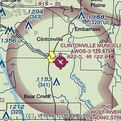
| Sectional chart |
|---|
|
| Airport distance calculator |
|---|
|
|
| Sunrise and sunset |
|---|
|
Times for 06-Jun-2026
| | Local
(UTC-5) | | Zulu
(UTC) |
|---|
| Morning civil twilight | | 04:35 | | 09:35 |
| Sunrise | | 05:12 | | 10:12 |
| Sunset | | 20:36 | | 01:36 |
| Evening civil twilight | | 21:12 | | 02:12 |
|
| Current date and time |
|---|
| Zulu (UTC) | 06-Jun-2026 07:36:38 |
|---|
| Local (UTC-5) | 06-Jun-2026 02:36:38 |
|---|
|
| METAR |
|---|
| KCLI | 060715Z AUTO 27005KT 10SM CLR 16/16 A2980 RMK AO2 T01600157
|
KEZS
13nm NE | 715-526-2967
060715Z AUTO 26003KT 10SM CLR 17/17 A2979 RMK AO2 T01680168
|
|
| TAF |
|---|
KATW
24nm SE | 060537Z 0606/0706 VRB03KT P6SM BKN250 FM060800 29003KT P6SM FEW250 TEMPO 0608/0611 3SM BR FM061400 29006KT P6SM SCT022 FM061800 31009G14KT P6SM SCT060 FM070000 10007KT P6SM SCT250
|
KGRB
27nm E | 060537Z 0606/0706 VRB03KT P6SM BKN250 FM060800 29003KT P6SM FEW250 TEMPO 0608/0611 3SM BR FM061400 29006KT P6SM SCT022 FM061800 31009G14KT P6SM SCT060 FM070000 10007KT P6SM SCT250
|
|
| NOTAMs |
|---|
NOTAMs are issued by the DoD/FAA and will open in a separate window not controlled by AirNav.
|
|

