FAA INFORMATION EFFECTIVE 16 APRIL 2026
Location
| FAA Identifier: | CPC |
| Lat/Long: | 34-16-22.3340N 078-42-53.9540W
34-16.372233N 078-42.899233W
34.2728706,-78.7149872
(estimated) |
| Elevation: | 99.4 ft. / 30.3 m (surveyed) |
| Variation: | 07W (1985) |
| From city: | 3 miles S of WHITEVILLE, NC |
| Time zone: | UTC -4 (UTC -5 during Standard Time) |
| Zip code: | 28472 |
Airport Operations
| Airport use: | Open to the public |
| Control tower: | no |
| ARTCC: | JACKSONVILLE CENTER |
| FSS: | RALEIGH FLIGHT SERVICE STATION |
| NOTAMs facility: | CPC (NOTAM-D service available) |
| Attendance: | MON-SAT 0800-1800, ALL SUN 0900-1800
FOR EMERGENCY SERVICE AFTER HRS CALL 910-654-3389 OR 910-625-5489. |
| Wind indicator: | lighted |
| Segmented circle: | yes |
| Lights: | ACTVT REIL RWY 06 & 24; MIRL RWY 06/24 - CTAF. PAPI RWY 06 & 24 ON CONSLY. |
| Beacon: | white-green (lighted land airport)
Operates sunset to sunrise. |
Airport Communications
| CTAF/UNICOM: | 122.8 |
| WX AWOS-3: | 118.375 (910-642-7508) |
| MYRTLE BEACH APPROACH: | 119.2 |
| MYRTLE BEACH DEPARTURE: | 119.2 |
- APCH/DEP SVC PRVDD BY JACKSONVILLE ARTCC ON FREQS 134.375/317.550 (MYRTLE BEACH RCAG) WHEN MYRTLE BEACH APCH CTL CLSD.
Nearby radio navigation aids
| VOR radial/distance | | VOR name | | Freq | | Var |
|---|
| CREr004/27.5 | | GRAND STRAND VORTAC | | 114.40 | | 03W |
Airport Services
| Fuel available: | 100LL JET-A1+
100LL:FUEL 24 HR CREDIT CARD SVC AVBL. |
| Parking: | tiedowns |
| Airframe service: | NONE |
| Powerplant service: | NONE |
| Bottled oxygen: | NONE |
| Bulk oxygen: | NONE |
Runway Information
Runway 6/24
| Dimensions: | 5500 x 75 ft. / 1676 x 23 m |
| Surface: | asphalt, in good condition |
| Weight bearing capacity: | | Single wheel: | 45.0 | | Double wheel: | 60.0 |
|
| Runway edge lights: | medium intensity |
| RUNWAY 6 | | RUNWAY 24 |
| Latitude: | 34-16.066762N | | 34-16.677692N |
| Longitude: | 078-43.302767W | | 078-42.495648W |
| Elevation: | 99.4 ft. | | 69.2 ft. |
| Traffic pattern: | left | | left |
| Runway heading: | 055 magnetic, 048 true | | 235 magnetic, 228 true |
| Markings: | nonprecision, in fair condition | | nonprecision, in fair condition |
| Visual slope indicator: | 2-light PAPI on left (3.00 degrees glide path) | | 2-light PAPI on left (3.25 degrees glide path) |
| Runway end identifier lights: | yes | | yes |
| Touchdown point: | yes, no lights | | yes, no lights |
| Obstructions: | 77 ft. trees, 2007 ft. from runway, 405 ft. left of centerline, 23:1 slope to clear | | 66 ft. trees, 2195 ft. from runway, 138 ft. left of centerline, 30:1 slope to clear |
Airport Ownership and Management from official FAA records
| Ownership: | Publicly-owned |
| Owner: | COLUMBUS COUNTY
111 WASHINGTON ST
WHITEVILLE, NC 28472
Phone 910-640-6601 |
| Manager: | PHIL EDWARDS
467 AIRPORT ROAD
WHITEVILLE, NC 28472
Phone 910-642-6187 |
Additional Remarks
| - | DEER AND TURKEYS ON INVOF ARPT. |
| - | ARPT UNATNDD EASTER SUNDAY, 4TH JULY, THANKSGIVING DAY, CHRISTMAS EVE AND CHRISTMAS DAY. |
| - | NO OFF-PAVEMENT LDG ALLOWED. |
| - | FOR CD CTC MYRTLE BEACH APCH AT 843-477-2727 OR 843-477-2704, WHEN APCH CLSD CTC JACKSONVILLE ARTCC AT 904-845-1592. |
Instrument Procedures
NOTE: All procedures below are presented as PDF files. If you need a reader for these files, you should download the free Adobe Reader.NOT FOR NAVIGATION. Please procure official charts for flight.
FAA instrument procedures published for use from 16 April 2026 at 0901Z to 14 May 2026 at 0900Z.
IAPs - Instrument Approach Procedures |
|---|
| RNAV (GPS) RWY 06 | |
download (195KB) |
| RNAV (GPS) RWY 24 | |
download (256KB) |
| NOTE: Special Alternate Minimums apply | |
download (168KB) |
| NOTE: Special Take-Off Minimums/Departure Procedures apply | |
download (387KB) |
Other nearby airports with instrument procedures:
5J9 - Twin City Airport (13 nm SW)
KEYF - Curtis L Brown Jr. Field Airport (21 nm N)
KLBT - Lumberton Regional Airport (26 nm NW)
KCRE - Grand Strand Airport (28 nm S)
KMAO - Marion County Airport (31 nm W)
|
|

Road maps at:
MapQuest
Bing
Google
| Aerial photo |
|---|
WARNING: Photo may not be current or correct
 Photo by King Martin
Photo taken 25-Jan-2016
looking northeast.
Photo by King Martin
Photo taken 25-Jan-2016
looking northeast.
Do you have a better or more recent aerial photo of Columbus County Regional Airport that you would like to share? If so, please send us your photo.
|
| Sectional chart |
|---|
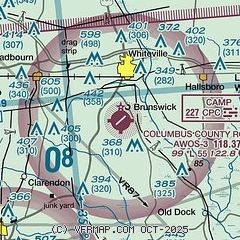
|
| Airport distance calculator |
|---|
|
|
| Sunrise and sunset |
|---|
|
Times for 05-May-2026
| | Local
(UTC-4) | | Zulu
(UTC) |
|---|
| Morning civil twilight | | 05:55 | | 09:55 |
| Sunrise | | 06:22 | | 10:22 |
| Sunset | | 20:01 | | 00:01 |
| Evening civil twilight | | 20:28 | | 00:28 |
|
| Current date and time |
|---|
| Zulu (UTC) | 05-May-2026 09:11:13 |
|---|
| Local (UTC-4) | 05-May-2026 05:11:13 |
|---|
|
| METAR |
|---|
| KCPC | 050855Z AUTO 00000KT 10SM CLR 10/09 A3004 RMK AO2 T01020090
|
|
| TAF |
|---|
KLBT
26nm NW | 050522Z 0506/0606 20005KT P6SM SCT250 FM051300 21008KT P6SM FEW250 FM051900 17011KT P6SM FEW250 FM060100 18006KT P6SM SCT250
|
KCRE
27nm S | 050522Z 0506/0606 21008KT P6SM SCT250 FM051400 19009KT P6SM FEW250 FM051800 17012G19KT P6SM FEW250 FM060100 18008KT P6SM SCT250
|
|
| NOTAMs |
|---|
NOTAMs are issued by the DoD/FAA and will open in a separate window not controlled by AirNav.
|
|

