FAA INFORMATION EFFECTIVE 16 APRIL 2026
Location
| FAA Identifier: | CRE |
| Lat/Long: | 33-48-42.3000N 078-43-26.2000W
33-48.705000N 078-43.436667W
33.8117500,-78.7239444
(estimated) |
| Elevation: | 31.6 ft. / 9.6 m (surveyed) |
| Variation: | 08W (2010) |
| From city: | 1 mile NW of NORTH MYRTLE BEACH, SC |
| Time zone: | UTC -4 (UTC -5 during Standard Time) |
| Zip code: | 29582 |
Airport Operations
| Airport use: | Open to the public |
| Control tower: | yes |
| ARTCC: | JACKSONVILLE CENTER |
| FSS: | ANDERSON FLIGHT SERVICE STATION |
| NOTAMs facility: | CRE (NOTAM-D service available) |
| Attendance: | 0700-2100 |
| Wind indicator: | lighted |
| Segmented circle: | yes |
| Lights: | AFTER 0000 ACTVT HIRL RY 05/23; REIL RY 05 AND MALSR RY 23 - CTAF. |
| Beacon: | white-green (lighted land airport)
Operates sunset to sunrise. |
Airport Communications
| CTAF: | 124.6 |
| UNICOM: | 122.95 |
| ATIS: | 119.625 |
| WX ASOS: | 119.625 (843-361-2802) |
| STRAND GROUND: | 121.8 257.6 [0700-2100] |
| STRAND TOWER: | 124.6 257.6 [0700-2100] |
| MYRTLE BEACH APPROACH: | 119.2 |
| MYRTLE BEACH DEPARTURE: | 119.2 |
| CLEARANCE DELIVERY: | 121.8 |
| WX AWOS-3PT at MYR (13 nm SW): | 123.925 (843-238-0335) |
| WX AWOS-3 at HYW (20 nm W): | 119.525 (843-397-8046) |
- APCH/DEP SVC PRVDD BY JACKSONVILLE ARTCC ON FREQS 134.375/317.550 (MYRTLE BEACH RCAG) WHEN APCH CTL CLSD.
Nearby radio navigation aids
| VOR radial/distance | | VOR name | | Freq | | Var |
|---|
| CRE at field | | GRAND STRAND VORTAC | | 114.40 | | 03W |
Airport Services
| Fuel available: | 100LL JET-A |
| Parking: | hangars and tiedowns |
| Airframe service: | NONE |
| Powerplant service: | NONE |
| Bottled oxygen: | NONE |
| Bulk oxygen: | NONE |
Runway Information
Runway 5/23
| Dimensions: | 5997 x 100 ft. / 1828 x 30 m |
| Surface: | asphalt, in good condition |
| Weight bearing capacity: | | PCN 29 /F/B/X/T | | Single wheel: | 76.0 | | Double wheel: | 112.0 |
|
| Runway edge lights: | high intensity |
| RUNWAY 5 | | RUNWAY 23 |
| Latitude: | 33-48.362028N | | 33-49.047935N |
| Longitude: | 078-43.863145W | | 078-43.009952W |
| Elevation: | 31.6 ft. | | 29.2 ft. |
| Traffic pattern: | left | | right |
| Runway heading: | 054 magnetic, 046 true | | 234 magnetic, 226 true |
| Markings: | precision, in good condition | | precision, in good condition |
| Visual slope indicator: | 2-light PAPI on left (3.00 degrees glide path) | | 2-light PAPI on right (2.98 degrees glide path) |
| Approach lights: | | | MALSR: 1,400 foot medium intensity approach lighting system with runway alignment indicator lights |
| Runway end identifier lights: | yes | | |
| Touchdown point: | yes, no lights | | yes, no lights |
| Instrument approach: | | | ILS/DME |
| Obstructions: | 59 ft. trees, 1434 ft. from runway, 273 ft. right of centerline, 20:1 slope to clear | | 98 ft. trees, 3450 ft. from runway, 672 ft. left of centerline, 33:1 slope to clear |
Airport Ownership and Management from official FAA records
| Ownership: | Publicly-owned |
| Owner: | HORRY COUNTY
PO BOX 1236
CONWAY, SC 29526
Phone 843-448-1580 |
| Manager: | JUDI OLMSTEAD
1100 JETPORT ROAD
MYRTLE BEACH, SC 29577
Phone 843-448-1580 |
Additional Remarks
| - | EXTENSIVE BANNER TOW OPERATIONS FM ARPT ALONG COAST LINE 10 NM NE TO 20 NM SW. |
| - | GULLS ON & INVOF ARPT. |
| - | FOR CD WHEN ATCT CLSD CTC MYRTLE BEACH APCH AT 843-477-2727/2704. WHEN MYR APCH CLSD CTC JACKSONVILLE ARTCC AT 904-845-1592. |
Instrument Procedures
NOTE: All procedures below are presented as PDF files. If you need a reader for these files, you should download the free Adobe Reader.NOT FOR NAVIGATION. Please procure official charts for flight.
FAA instrument procedures published for use from 16 April 2026 at 0901Z to 14 May 2026 at 0900Z.
IAPs - Instrument Approach Procedures |
|---|
| ILS OR LOC RWY 23 | |
download (250KB) |
| RNAV (GPS) RWY 05 | |
download (260KB) |
| RNAV (GPS) RWY 23 | |
download (237KB) |
| VOR RWY 05 | |
download (204KB) |
| VOR RWY 23 | |
download (208KB) |
| NOTE: Special Alternate Minimums apply | |
download (144KB) |
| NOTE: Special Take-Off Minimums/Departure Procedures apply | |
download (141KB) |
Other nearby airports with instrument procedures:
KMYR - Myrtle Beach International Airport (13 nm SW)
5J9 - Twin City Airport (18 nm NW)
KHYW - Conway-Horry County Airport (20 nm W)
KCPC - Columbus County Regional Airport (28 nm N)
KSUT - Cape Fear Regional Jetport/Howie Franklin Field Airport (33 nm E)
|
|

Road maps at:
MapQuest
Bing
Google
| Aerial photo |
|---|
WARNING: Photo may not be current or correct
 Photo by Fred Schwarz
Photo taken 22-May-2015
rom 2000 feet looking southwest.
Photo by Fred Schwarz
Photo taken 22-May-2015
rom 2000 feet looking southwest.
Do you have a better or more recent aerial photo of Grand Strand Airport that you would like to share? If so, please send us your photo.
|
| Sectional chart |
|---|
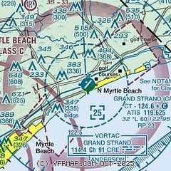
|
| Airport distance calculator |
|---|
|
|
| Sunrise and sunset |
|---|
|
Times for 12-May-2026
| | Local
(UTC-4) | | Zulu
(UTC) |
|---|
| Morning civil twilight | | 05:50 | | 09:50 |
| Sunrise | | 06:17 | | 10:17 |
| Sunset | | 20:05 | | 00:05 |
| Evening civil twilight | | 20:33 | | 00:33 |
|
| Current date and time |
|---|
| Zulu (UTC) | 12-May-2026 09:23:16 |
|---|
| Local (UTC-4) | 12-May-2026 05:23:16 |
|---|
|
| METAR |
|---|
| KCRE | 120853Z AUTO 02009KT 10SM CLR 12/10 A3014 RMK AO1 SLP208 T01220100 58006
|
KMYR
13nm SW | 120853Z AUTO 01008KT 10SM CLR 13/11 A3016 RMK AO2 SLP212 T01330106 58005 $
|
KHYW
20nm W | 120855Z AUTO 02006KT 10SM CLR 12/10 A3016 RMK AO2
|
|
| TAF |
|---|
| KCRE | 120520Z 1206/1306 03008KT P6SM BKN150 FM121600 09013KT P6SM SCT250 FM130000 09008KT P6SM BKN250
|
KMYR
13nm SW | 120520Z 1206/1306 03009KT P6SM BKN120 FM121600 09013KT P6SM BKN250 FM130000 09008KT P6SM BKN250
|
|
| NOTAMs |
|---|
NOTAMs are issued by the DoD/FAA and will open in a separate window not controlled by AirNav.
|
|


