FAA INFORMATION EFFECTIVE 14 MAY 2026
Location
| FAA Identifier: | CSQ |
| Lat/Long: | 41-01-17.2000N 094-21-47.9000W
41-01.286667N 094-21.798333W
41.0214444,-94.3633056
(estimated) |
| Elevation: | 1299.7 ft. / 396.1 m (surveyed) |
| Variation: | 04E (1995) |
| From city: | 3 miles S of CRESTON, IA |
| Time zone: | UTC -5 (UTC -6 during Standard Time) |
| Zip code: | 50801 |
Airport Operations
| Airport use: | Open to the public |
| Activation date: | 12/1958 |
| Control tower: | no |
| ARTCC: | MINNEAPOLIS CENTER |
| FSS: | FORT DODGE FLIGHT SERVICE STATION |
| NOTAMs facility: | CSQ (NOTAM-D service available) |
| Attendance: | MON-FRI 0800-1700, ALL SAT-SUN ON CALL |
| Wind indicator: | lighted |
| Segmented circle: | no |
| Lights: | ACTVT REIL RWY 16 & 34; PAPI RWY 16 & 34; MIRL RWY 16/34 - CTAF. MIRL RWY 16/34 PRESET LOW INTST; INCR INTST - CTAF. |
| Beacon: | white-green (lighted land airport)
Operates sunset to sunrise. |
Airport Communications
| CTAF/UNICOM: | 122.8 |
| WX AWOS-3: | 124.75 (641-782-6286) |
- APCH/DEP SVC PRVDD BY MINNEAPOLIS ARTCC ON FREQS 125.65/306.950 (DES MOINES RCAG).
Nearby radio navigation aids
| VOR radial/distance | | VOR name | | Freq | | Var |
|---|
| LMNr318/31.2 | | LAMONI VOR/DME | | 116.70 | | 07E |
Airport Services
| Fuel available: | 100LL JET-A |
| Parking: | hangars and tiedowns |
| Airframe service: | MINOR |
| Powerplant service: | MINOR |
Runway Information
Runway 16/34
| Dimensions: | 4901 x 75 ft. / 1494 x 23 m |
| Surface: | concrete, in excellent condition |
| Weight bearing capacity: | | PCN 13 /F/D/X/T | | Single wheel: | 15.0 |
|
| Runway edge lights: | medium intensity |
| RUNWAY 16 | | RUNWAY 34 |
| Latitude: | 41-01.657105N | | 41-00.878153N |
| Longitude: | 094-21.967552W | | 094-21.689012W |
| Elevation: | 1288.6 ft. | | 1294.9 ft. |
| Traffic pattern: | left | | left |
| Runway heading: | 161 magnetic, 165 true | | 341 magnetic, 345 true |
| Markings: | nonprecision, in good condition | | nonprecision, in good condition |
| Visual slope indicator: | 2-light PAPI on left (3.00 degrees glide path) | | 2-light PAPI on left (3.00 degrees glide path) |
| Runway end identifier lights: | yes | | yes |
| Touchdown point: | yes, no lights | | yes, no lights |
| Obstructions: | 13 ft. fence, 520 ft. from runway, 24:1 slope to clear | | 5 ft. tree, lighted, 326 ft. from runway, 135 ft. right of centerline, 25:1 slope to clear |
Runway 4/22
| Dimensions: | 1692 x 100 ft. / 516 x 30 m |
| Surface: | turf, in good condition |
| Runway edge markings: | YELLOW CONES. |
| Operational restrictions: | CLSD DURG WINTER. |
| RUNWAY 4 | | RUNWAY 22 |
| Latitude: | 41-01.239927N | | 41-01.437622N |
| Longitude: | 094-21.840830W | | 094-21.581472W |
| Elevation: | | | 1299.7 ft. |
| Traffic pattern: | left | | left |
| Runway heading: | 041 magnetic, 045 true | | 221 magnetic, 225 true |
Airport Ownership and Management from official FAA records
| Ownership: | Publicly-owned |
| Owner: | CITY OF CRESTON
116 W. ADAMS
CRESTON, IA 50801
Phone 641-782-2000
TADD CARR |
| Manager: | TYLER WEST
1945 CHERRY STREET ROAD
CRESTON, IA 50801
Phone 641-278-0203
641-782-2383 |
Additional Remarks
| A30A-04 | SHARP DROP AT RWY END. |
| - | REMOTE CTL OPS INVOF ARPT. |
| - | FOR CD CTC MINNEAPOLIS ARTCC AT 651-463-5588. |
Instrument Procedures
NOTE: All procedures below are presented as PDF files. If you need a reader for these files, you should download the free Adobe Reader.NOT FOR NAVIGATION. Please procure official charts for flight.
FAA instrument procedures published for use from 14 May 2026 at 0901Z to 11 June 2026 at 0900Z.
IAPs - Instrument Approach Procedures |
|---|
| RNAV (GPS) RWY 16 | |
download (235KB) |
| RNAV (GPS) RWY 34 | |
download (215KB) |
| NOTE: Special Alternate Minimums apply | |
download (16KB) |
| NOTE: Special Take-Off Minimums/Departure Procedures apply | |
download (158KB) |
Other nearby airports with instrument procedures:
KCRZ - Corning Municipal Airport (18 nm W)
KGFZ - Greenfield Municipal Airport (19 nm N)
3Y3 - Winterset Municipal Airport (26 nm NE)
I75 - Osceola Municipal Airport (31 nm E)
KLWD - Lamoni Municipal Airport (31 nm SE)
|
|

Road maps at:
MapQuest
Bing
Google
| Aerial photo |
|---|
WARNING: Photo may not be current or correct

Do you have a better or more recent aerial photo of Creston Municipal Airport that you would like to share? If so, please send us your photo.
|
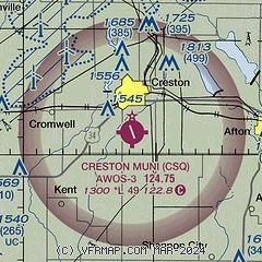
| Sectional chart |
|---|
|
| Airport distance calculator |
|---|
|
|
| Sunrise and sunset |
|---|
|
Times for 31-May-2026
| | Local
(UTC-5) | | Zulu
(UTC) |
|---|
| Morning civil twilight | | 05:16 | | 10:16 |
| Sunrise | | 05:49 | | 10:49 |
| Sunset | | 20:41 | | 01:41 |
| Evening civil twilight | | 21:14 | | 02:14 |
|
| Current date and time |
|---|
| Zulu (UTC) | 31-May-2026 21:57:31 |
|---|
| Local (UTC-5) | 31-May-2026 16:57:31 |
|---|
|
| METAR |
|---|
| KCSQ | 312135Z AUTO 19008KT 10SM CLR 29/18 A2989 RMK AO2
|
|
| TAF |
|---|
KDSM
44nm NE | 311736Z 3118/0118 11008KT P6SM SCT015 BKN025 FM311900 15010KT P6SM SCT020 BKN035 FM312100 14009KT P6SM SCT050 FM010700 10005KT P6SM FEW012 SCT025 BKN035 FM011500 06005KT P6SM SCT040
|
|
| NOTAMs |
|---|
NOTAMs are issued by the DoD/FAA and will open in a separate window not controlled by AirNav.
|
|

