FAA INFORMATION EFFECTIVE 11 JUNE 2026
Location
| FAA Identifier: | CUH |
| Lat/Long: | 35-57-00.1000N 096-46-24.3000W
35-57.001667N 096-46.405000W
35.9500278,-96.7734167
(estimated) |
| Elevation: | 925.1 ft. / 282.0 m (surveyed) |
| Variation: | 05E (2005) |
| From city: | 2 miles S of CUSHING, OK |
| Time zone: | UTC -5 (UTC -6 during Standard Time) |
| Zip code: | 74023 |
Airport Operations
| Airport use: | Open to the public |
| Activation date: | 11/1943 |
| Control tower: | no |
| ARTCC: | KANSAS CITY CENTER |
| FSS: | MC ALESTER FLIGHT SERVICE STATION |
| NOTAMs facility: | CUH (NOTAM-D service available) |
| Attendance: | MON-FRI 0800-1700
UNATNDD FED HOL. |
| Wind indicator: | lighted |
| Segmented circle: | yes |
| Lights: | ACTVT REIL RWY 18 & 36 - CTAF; PAPI RWY 18 & 36 ON CONSLY; MIRL RWY 18/36 SS-SR PRESET MED INTST; INCR INTST - CTAF. |
| Beacon: | white-green (lighted land airport)
Operates sunset to sunrise. |
Airport Communications
| CTAF/UNICOM: | 122.8 |
| WX AWOS-3PT: | 118.25 ((918) 225-6072) |
| WX AWOS-3PT at CQB (14 nm S): | 119.275 (405-258-6724) |
| WX ASOS at SWO (20 nm NW): | 135.725 (405-743-8150) |
- APCH/DEP CTL SVC PRVDD BY KANSAS CITY ARTCC (ZKC) ON FREQS 127.8/319.1 (PONCA CITY RCAG).
Nearby radio navigation aids
| VOR radial/distance | | VOR name | | Freq | | Var |
|---|
| SWOr131/22.2 | | STILLWATER VOR/DME | | 108.40 | | 07E |
Airport Services
| Fuel available: | 100LL JET-A
100LL:FUEL AVBL H24 WITH CREDIT CARD. |
| Parking: | hangars and tiedowns |
| Airframe service: | MAJOR |
| Powerplant service: | MAJOR |
| Bottled oxygen: | LOW |
| Bulk oxygen: | LOW |
Runway Information
Runway 18/36
| Dimensions: | 5201 x 100 ft. / 1585 x 30 m |
| Surface: | concrete/grooved, in good condition |
| Weight bearing capacity: | | PCN 4 /R/B/X/T | | Single wheel: | 30.0 |
|
| Runway edge lights: | medium intensity |
| RUNWAY 18 | | RUNWAY 36 |
| Latitude: | 35-57.435015N | | 35-56.577797N |
| Longitude: | 096-46.156885W | | 096-46.148665W |
| Elevation: | 916.0 ft. | | 878.7 ft. |
| Traffic pattern: | left | | left |
| Runway heading: | 175 magnetic, 180 true | | 355 magnetic, 360 true |
| Declared distances: | TORA:5201 TODA:5201 ASDA:4986 LDA:4986 | | TORA:5201 TODA:5201 ASDA:5201 LDA:4986 |
| Markings: | nonprecision, in fair condition | | nonprecision, in fair condition |
| Visual slope indicator: | 4-light PAPI on left (3.00 degrees glide path) | | 4-light PAPI on left (3.00 degrees glide path) |
| Runway end identifier lights: | yes | | yes |
| Touchdown point: | yes, no lights | | yes, no lights |
| Obstructions: | none | | 50 ft. trees, 1373 ft. from runway, 48 ft. right of centerline, 23:1 slope to clear |
Runway 8/26
| Dimensions: | 2700 x 40 ft. / 823 x 12 m |
| Surface: | turf, in good condition |
| RUNWAY 8 | | RUNWAY 26 |
| Latitude: | 35-57.030802N | | 35-57.030320N |
| Longitude: | 096-46.931708W | | 096-46.384420W |
| Elevation: | 923.8 ft. | | 900.6 ft. |
| Traffic pattern: | left | | left |
| Runway heading: | 085 magnetic, 090 true | | 265 magnetic, 270 true |
| Markings: | NSTD, in good condition | | NSTD, in good condition |
| Touchdown point: | yes, no lights | | yes, no lights |
| Obstructions: | 32 ft. trees, 387 ft. from runway, 12:1 slope to clear | | none |
Runway 2/20
| Dimensions: | 2650 x 60 ft. / 808 x 18 m |
| Surface: | turf, in good condition |
| RUNWAY 2 | | RUNWAY 20 |
| Latitude: | 35-56.817612N | | 35-57.191807N |
| Longitude: | 096-46.508175W | | 096-46.231150W |
| Elevation: | 891.1 ft. | | 905.1 ft. |
| Traffic pattern: | left | | left |
| Runway heading: | 026 magnetic, 031 true | | 206 magnetic, 211 true |
| Markings: | NSTD, in good condition | | NSTD, in good condition |
| Touchdown point: | yes, no lights | | yes, no lights |
| Obstructions: | 35 ft. trees, 528 ft. from runway, 15:1 slope to clear | | none |
Runway 11/29
| Dimensions: | 2500 x 50 ft. / 762 x 15 m |
| Surface: | turf, in good condition |
| RUNWAY 11 | | RUNWAY 29 |
| Latitude: | 35-57.061235N | | 35-56.845450N |
| Longitude: | 096-46.913700W | | 096-46.482002W |
| Elevation: | 925.1 ft. | | 891.0 ft. |
| Traffic pattern: | left | | left |
| Runway heading: | 117 magnetic, 122 true | | 297 magnetic, 302 true |
| Markings: | NSTD, in good condition | | NSTD, in good condition |
| Touchdown point: | yes, no lights | | yes, no lights |
| Obstructions: | 42 ft. trees, 475 ft. from runway, 11:1 slope to clear | | none |
Airport Ownership and Management from official FAA records
| Ownership: | Publicly-owned |
| Owner: | CITY OF CUSHING
PO BOX 311
CUSHING, OK 74023
Phone 918-225-2394 |
| Manager: | MIKE MIDDLETON
2414 TOM MALONEY DR
CUSHING, OK 74023
Phone 918-225-0881 |
Additional Remarks
| - | FOR CD CTC KANSAS CITY ARTCC AT 913-254-8508. |
| - | RWY 08/26 & 11/29 SOFT WHEN WET. |
Instrument Procedures
NOTE: All procedures below are presented as PDF files. If you need a reader for these files, you should download the free Adobe Reader.NOT FOR NAVIGATION. Please procure official charts for flight.
FAA instrument procedures published for use from 11 June 2026 at 0901Z to 09 July 2026 at 0900z.
IAPs - Instrument Approach Procedures |
|---|
| RNAV (GPS) RWY 18 | |
download (257KB) |
| RNAV (GPS) RWY 36 | |
download (223KB) |
| NOTE: Special Alternate Minimums apply | |
download (108KB) |
| NOTE: Special Take-Off Minimums/Departure Procedures apply | |
download (178KB) |
Other nearby airports with instrument procedures:
KCQB - Chandler Regional Airport (14 nm S)
3F7 - Jones Memorial Airport (19 nm SE)
KSWO - Stillwater Regional Airport (20 nm NW)
O47 - Prague Municipal Airport (28 nm S)
KGOK - Guthrie/Edmond Regional Airport (32 nm W)
|
|

Road maps at:
MapQuest
Bing
Google
| Aerial photo |
|---|
WARNING: Photo may not be current or correct
 Taken in the Summer of 2002
Do you have a better or more recent aerial photo of Cushing Municipal Airport that you would like to share? If so, please send us your photo.
|
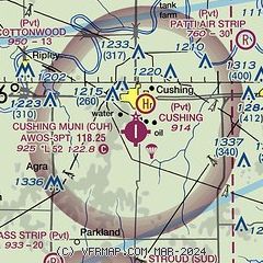
| Sectional chart |
|---|
|
| Airport distance calculator |
|---|
|
|
| Sunrise and sunset |
|---|
|
Times for 11-Jun-2026
| | Local
(UTC-5) | | Zulu
(UTC) |
|---|
| Morning civil twilight | | 05:41 | | 10:41 |
| Sunrise | | 06:11 | | 11:11 |
| Sunset | | 20:43 | | 01:43 |
| Evening civil twilight | | 21:13 | | 02:13 |
|
| Current date and time |
|---|
| Zulu (UTC) | 11-Jun-2026 19:00:42 |
|---|
| Local (UTC-5) | 11-Jun-2026 14:00:42 |
|---|
|
| METAR |
|---|
| KCUH | 111835Z AUTO 21014KT 10SM BKN042 31/21 A2978 RMK AO2 T03110213
|
KCQB
14nm S | 111830Z AUTO 21014G19KT 160V230 10SM SCT040 SCT049 33/23 A2979 RMK AO2 T03290233
|
KSWO
20nm NW | 111853Z 21011G17KT 10SM BKN049 OVC060 32/23 A2976 RMK AO2 SLP063 T03170228
|
|
| TAF |
|---|
KSWO
20nm NW | 111737Z 1118/1218 22020G25KT P6SM BKN035 FM112200 34015G20KT P6SM BKN050 PROB30 1122/1201 -TSRA BKN050CB FM120100 03010G15KT P6SM OVC070 FM120500 VRB05KT P6SM OVC080 FM121500 12010KT P6SM SCT090 BKN250
|
|
| NOTAMs |
|---|
NOTAMs are issued by the DoD/FAA and will open in a separate window not controlled by AirNav.
|
|

