FAA INFORMATION EFFECTIVE 09 JULY 2026
Location
| FAA Identifier: | SWO |
| Lat/Long: | 36-09-41.0020N 097-05-09.2160W
36-09.683367N 097-05.153600W
36.1613894,-97.0858933
(estimated) |
| Elevation: | 1000.3 ft. / 304.9 m (surveyed) |
| Variation: | 05E (2005) |
| From city: | 3 miles NW of STILLWATER, OK |
| Time zone: | UTC -5 (UTC -6 during Standard Time) |
| Zip code: | 74075 |
Airport Operations
| Airport use: | Open to the public |
| Activation date: | 05/1943 |
| Control tower: | yes |
| ARTCC: | KANSAS CITY CENTER |
| FSS: | MC ALESTER FLIGHT SERVICE STATION |
| NOTAMs facility: | SWO (NOTAM-D service available) |
| Attendance: | 0800-2200
AFT HR FUEL - 405-377-5326. |
| Pattern altitude: | 1800.3 ft. MSL
TPA LGT ACFT 800 FT AGL, TURBO PROPS/JETS 1500 FT AGL. |
| Wind indicator: | lighted |
| Segmented circle: | no |
| Lights: | ACTVT MALSR RWY 17; REIL RWY 35; PAPI RWY 22; MIRL RWY 04/22 & 17/35 - CTAF. MIRL RWY 17/35 PRESET LOW INTST; INCR INTST - CTAF. |
| Beacon: | white-green (lighted land airport)
Operates sunset to sunrise. |
| Fire and rescue: | ARFF index B |
| Airline operations: | 24 HRS PPR FOR UNSKED ACFT OPS WITH MORE THAN 9 PAX CALL AMGR 405-533-2222. |
Airport Communications
| CTAF: | 125.35 |
| UNICOM: | 122.95 |
| WX ASOS: | 135.725 (405-743-8150) |
| STILLWATER GROUND: | 121.6 [0800-2200] |
| STILLWATER TOWER: | 125.35 [0800-2200] |
| WX AWOS-3PT at CUH (20 nm SE): | 118.25 ((918) 225-6072) |
- APCH/DEP CTL SVC PRVDD BY KANSAS CITY ARTCC (ZKC) ON FREQS 127.8/319.1 (PONCA CITY RCAG).
Nearby radio navigation aids
| VOR radial/distance | | VOR name | | Freq | | Var |
|---|
| SWOr176/3.8 | | STILLWATER VOR/DME | | 108.40 | | 07E |
| PERr168/35.3 | | PIONEER VORTAC | | 113.20 | | 06E |
| ODGr103/36.3 | | WOODRING VOR/DME | | 109.00 | | 08E |
| NDB name | | Hdg/Dist | | Freq | | Var | | ID |
|---|
| GABEH | | 174/4.5 | | 255 | | 05E | | SW | ... .-- |
Airport Services
| Fuel available: | 100LL JET-A |
| Parking: | hangars and tiedowns |
| Airframe service: | MAJOR |
| Powerplant service: | MAJOR |
Runway Information
Runway 17/35
| Dimensions: | 7401 x 100 ft. / 2256 x 30 m |
| Surface: | concrete/grooved, in good condition |
| Weight bearing capacity: | | Single wheel: | 100.0, STRENGTHS BASED ON RESTRICTED OPS. | | Double wheel: | 157.0 | | Double tandem: | 310.0 |
|
| Runway edge lights: | medium intensity |
| RUNWAY 17 | | RUNWAY 35 |
| Latitude: | 36-10.338718N | | 36-09.118993N |
| Longitude: | 097-05.211477W | | 097-05.198207W |
| Elevation: | 1000.3 ft. | | 966.0 ft. |
| Traffic pattern: | left | | left |
| Runway heading: | 174 magnetic, 179 true | | 354 magnetic, 359 true |
| Declared distances: | TORA:7401 TODA:7401 ASDA:7401 LDA:7401 | | TORA:7401 TODA:7401 ASDA:7401 LDA:7401 |
| Markings: | precision, in good condition | | precision, in good condition |
| Visual slope indicator: | 4-light PAPI on left (3.00 degrees glide path)
UNUSBL BYD 9 DEGS LEFT & RIGHT OF CNTRLN. | | 4-light PAPI on left (3.00 degrees glide path)
UNUSBL BYD 9 DEGS LEFT & 8 DEGS RIGHT OF CNTRLN. |
| Approach lights: | MALSR: 1,400 foot medium intensity approach lighting system with runway alignment indicator lights | | |
| Runway end identifier lights: | | | yes |
| Touchdown point: | yes, no lights | | yes, no lights |
| Instrument approach: | ILS/DME | | |
Runway 4/22
| Dimensions: | 5002 x 75 ft. / 1525 x 23 m |
| Surface: | asphalt, in good condition |
| Weight bearing capacity: | | Single wheel: | 34.0 | | Double wheel: | 60.0 |
|
| Runway edge lights: | medium intensity |
| RUNWAY 4 | | RUNWAY 22 |
| Latitude: | 36-09.322087N | | 36-09.910045N |
| Longitude: | 097-05.434055W | | 097-04.721472W |
| Elevation: | 960.9 ft. | | 985.7 ft. |
| Traffic pattern: | left | | left |
| Runway heading: | 040 magnetic, 045 true | | 220 magnetic, 225 true |
| Declared distances: | TORA:5002 TODA:5002 ASDA:5002 LDA:5002 | | TORA:5002 TODA:5002 ASDA:5002 LDA:5002 |
| Markings: | basic, in good condition | | basic, in good condition |
| Visual slope indicator: | 4-light PAPI on left (3.00 degrees glide path)
UNUSBL BYD 9 DEGS RIGHT OF CNTRLN. | | 4-light PAPI on left (3.00 degrees glide path) |
| Touchdown point: | yes, no lights | | yes, no lights |
| Obstructions: | 3 ft. gnd, 520 ft. from runway, 45:1 slope to clear | | none |
Airport Ownership and Management from official FAA records
| Ownership: | Publicly-owned |
| Owner: | CITY OF STILLWATER
723 SOUTH LEWIS
STILLWATER, OK 74074
Phone 405-372-0025 |
| Manager: | KELLIE REED
3304 N AIRPORT INDUSTRIAL ACCESS RD
STILLWATER, OK 74075
Phone 405-533-8425 |
Additional Remarks
| A39-04/22 | PCR VALUE: 158/R/C/W/T |
| A39-17/35 | PCR VALUE: 582/R/C/W/T |
| - | STUDENT OPS & BIRDS ON & INVOF ARPT. |
| - | ALL RAMPS UNCONTROLLED. |
| - | AFT HRS FUEL AVBL WITH PPR; CTC 405-624-5463. |
| - | FOR GA TSNT PRKG ON HANGAR 1 RAMP CTC FBO ON UNICOM OR FONE 405-624-5463. |
| - | OPNS ABV PCR VALUE BY PPR. |
| - | ARFF INDEX B MAINTAINED; ARFF INDEX C PPR. |
| - | PTN OF TWY F NORTH OF T-HNGR 2 NOT VSBL FROM ATCT. |
| - | FOR CD IF UNA TO CTC ON FSS FREQ, CTC KANSAS CITY ARTCC AT 913-254-8508. |
Instrument Procedures
NOTE: All procedures below are presented as PDF files. If you need a reader for these files, you should download the free Adobe Reader.NOT FOR NAVIGATION. Please procure official charts for flight.
FAA instrument procedures published for use from 09 July 2026 at 0901Z to 06 August 2026 at 0900Z.
IAPs - Instrument Approach Procedures |
|---|
| ILS OR LOC RWY 17 **CHANGED** | |
download (285KB) |
| RNAV (GPS) RWY 17 **CHANGED** | |
download (265KB) |
| RNAV (GPS) RWY 35 **CHANGED** | |
download (254KB) |
| VOR/DME RWY 35 **CHANGED** | |
download (226KB) |
| VOR RWY 17 **CHANGED** | |
download (219KB) |
| NOTE: Special Alternate Minimums apply | |
download (123KB) |
| NOTE: Special Take-Off Minimums/Departure Procedures apply | |
download (389KB) |
Other nearby airports with instrument procedures:
F22 - Perry Municipal Airport (16 nm NW)
KCUH - Cushing Municipal Airport (20 nm SE)
KGOK - Guthrie/Edmond Regional Airport (25 nm SW)
KCQB - Chandler Regional Airport (29 nm SE)
KPNC - Ponca City Regional Airport (34 nm N)
|
|

Road maps at:
MapQuest
Bing
Google
| Aerial photo |
|---|
WARNING: Photo may not be current or correct
 Aerial photo provided by Beacon Aviation Inc. of Alba, TX
Taken in September 2005
Aerial photo provided by Beacon Aviation Inc. of Alba, TX
Taken in September 2005
Do you have a better or more recent aerial photo of Stillwater Regional Airport that you would like to share? If so, please send us your photo.
|
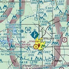
| Sectional chart |
|---|
|
CAUTION: Diagram may not be current
 Download PDF
of official airport diagram from the FAA
| Airport distance calculator |
|---|
|
|
| Sunrise and sunset |
|---|
|
Times for 30-Jul-2026
| | Local
(UTC-5) | | Zulu
(UTC) |
|---|
| Morning civil twilight | | 06:06 | | 11:06 |
| Sunrise | | 06:35 | | 11:35 |
| Sunset | | 20:35 | | 01:35 |
| Evening civil twilight | | 21:03 | | 02:03 |
|
| Current date and time |
|---|
| Zulu (UTC) | 31-Jul-2026 04:48:27 |
|---|
| Local (UTC-5) | 30-Jul-2026 23:48:27 |
|---|
|
| METAR |
|---|
| KSWO | 310353Z AUTO 15012KT 10SM CLR 32/20 A2988 RMK AO2 SLP102 T03170200
|
KCUH
20nm SE | 310435Z AUTO 18008KT 10SM CLR 31/19 A2990 RMK AO2 T03050190
|
|
| TAF |
|---|
| KSWO | 301738Z 3018/3118 15012KT P6SM SCT150 FM310100 16008KT P6SM SCT250 PROB30 3109/3114 -SHRA FM311400 22011KT P6SM BKN250
|
|
| NOTAMs |
|---|
NOTAMs are issued by the DoD/FAA and will open in a separate window not controlled by AirNav.
|
|


