FAA INFORMATION EFFECTIVE 14 MAY 2026
Location
| FAA Identifier: | DKK |
| Lat/Long: | 42-29-38.2000N 079-16-16.0000W
42-29.636667N 079-16.266667W
42.4939444,-79.2711111
(estimated) |
| Elevation: | 692.3 ft. / 211.0 m (surveyed) |
| Variation: | 10W (2015) |
| From city: | 3 miles E of DUNKIRK, NY |
| Time zone: | UTC -4 (UTC -5 during Standard Time) |
| Zip code: | 14048 |
Airport Operations
| Airport use: | Open to the public |
| Activation date: | 11/1943 |
| Control tower: | no |
| ARTCC: | CLEVELAND CENTER |
| FSS: | BUFFALO FLIGHT SERVICE STATION |
| NOTAMs facility: | DKK (NOTAM-D service available) |
| Attendance: | 0700-1700
EXC FEDERAL HOLS. |
| Wind indicator: | lighted |
| Segmented circle: | yes |
| Lights: | ACTVT HIRL RWY 06/24, MIRL RWY 15/33, PAPI 06, 24, 15, & 33, & REIL RWY 6 & 24 -CTAF. |
| Beacon: | white-green (lighted land airport)
Operates sunset to sunrise. |
Airport Communications
| CTAF/UNICOM: | 123.075 |
| WX ASOS: | 119.275 (716-366-7664) |
| BUFFALO APPROACH: | 126.5 |
| BUFFALO DEPARTURE: | 126.5 |
Nearby radio navigation aids
| VOR radial/distance | | VOR name | | Freq | | Var |
|---|
| JHWr347/19.5 | | JAMESTOWN VOR/DME | | 114.70 | | 07W |
Airport Services
| Fuel available: | 100LL JET-A JET-A+ |
| Parking: | hangars and tiedowns |
| Airframe service: | MINOR |
| Powerplant service: | MAJOR |
| Bottled oxygen: | NONE |
| Bulk oxygen: | HIGH/LOW |
Runway Information
Runway 6/24
| Dimensions: | 6000 x 100 ft. / 1829 x 30 m |
| Surface: | asphalt/grooved, in fair condition |
| Weight bearing capacity: | | Single wheel: | 49.6 | | Double wheel: | 68.0 | | Double tandem: | 130.0 |
|
| Runway edge lights: | high intensity |
| RUNWAY 6 | | RUNWAY 24 |
| Latitude: | 42-29.363342N | | 42-30.007513N |
| Longitude: | 079-16.687432W | | 079-15.675802W |
| Elevation: | 673.9 ft. | | 661.5 ft. |
| Traffic pattern: | left | | left |
| Runway heading: | 059 magnetic, 049 true | | 239 magnetic, 229 true |
| Markings: | nonprecision, in fair condition | | nonprecision, in fair condition |
| Visual slope indicator: | 4-light PAPI on left (3.00 degrees glide path) | | 4-light PAPI on left (3.00 degrees glide path) |
| Runway end identifier lights: | yes | | yes |
| Touchdown point: | yes, no lights | | yes, no lights |
| Obstructions: | none | | 30 ft. tree, 405 ft. from runway, 44 ft. right of centerline, 6:1 slope to clear |
Runway 15/33
| Dimensions: | 4000 x 100 ft. / 1219 x 30 m |
| Surface: | asphalt, in fair condition |
| Weight bearing capacity: | | Single wheel: | 49.6 | | Double wheel: | 68.0 | | Double tandem: | 130.0 |
|
| Runway edge lights: | medium intensity |
| RUNWAY 15 | | RUNWAY 33 |
| Latitude: | 42-29.811867N | | 42-29.312708N |
| Longitude: | 079-16.682273W | | 079-16.102027W |
| Elevation: | 660.4 ft. | | 692.3 ft. |
| Traffic pattern: | left | | left |
| Runway heading: | 149 magnetic, 139 true | | 329 magnetic, 319 true |
| Markings: | nonprecision, in fair condition | | nonprecision, in fair condition |
| Visual slope indicator: | 4-light PAPI on left (3.00 degrees glide path) | | 4-light PAPI on left (3.10 degrees glide path) |
| Runway end identifier lights: | | | no |
| Touchdown point: | yes, no lights | | yes, no lights |
| Obstructions: | 70 ft. tree, 787 ft. from runway, 300 ft. right of centerline, 8:1 slope to clear | | 62 ft. trees, 775 ft. from runway, 273 ft. right of centerline, 9:1 slope to clear |
Airport Ownership and Management from official FAA records
| Ownership: | Publicly-owned |
| Owner: | CHAUT CO
N. ERIE STREET
MAYVILLE, NY 14701
Phone 716-753-8406 |
| Manager: | JOHN MACHEMER
3163 AIRPORT DR
JAMESTOWN, NY 14701
Phone 716-581-0062 |
Additional Remarks
| - | DEER & BIRDS INVOF AIRPORT |
| - | FICONS NOT RGLRLY MNT. |
| - | COLD TEMPERATURE AIRPORT. ALTITUDE CORRECTION REQUIRED AT OR BELOW -21C. |
| - | FOR CD CTC BUFFALO ATCT AT 716-626-6939/6919. |
Instrument Procedures
NOTE: All procedures below are presented as PDF files. If you need a reader for these files, you should download the free Adobe Reader.NOT FOR NAVIGATION. Please procure official charts for flight.
FAA instrument procedures published for use from 14 May 2026 at 0901Z to 11 June 2026 at 0900Z.
IAPs - Instrument Approach Procedures |
|---|
| RNAV (GPS) RWY 15 | |
download (194KB) |
| RNAV (GPS) RWY 33 | |
download (223KB) |
| RNAV (GPS)-A | |
download (187KB) |
| RNAV (GPS)-B | |
download (198KB) |
| NOTE: Special Alternate Minimums apply | |
download (40KB) |
| NOTE: Special Take-Off Minimums/Departure Procedures apply | |
download (267KB) |
Other nearby airports with instrument procedures:
KJHW - Chautauqua County/Jamestown Airport (20 nm S)
9G0 - Buffalo Airfield (33 nm NE)
KBUF - Buffalo Niagara International Airport (36 nm NE)
KBQR - Buffalo-Lancaster Regional Airport (39 nm NE)
8G2 - Corry-Lawrence Airport (39 nm SW)
|
|

Road maps at:
MapQuest
Bing
Google
| Aerial photo |
|---|
WARNING: Photo may not be current or correct
 Photo by David Newcomer
Photo taken 10-Apr-2016
from 3,000 AGL looking north.
Photo by David Newcomer
Photo taken 10-Apr-2016
from 3,000 AGL looking north.
Do you have a better or more recent aerial photo of Chautauqua County/Dunkirk Airport that you would like to share? If so, please send us your photo.
|
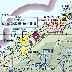
| Sectional chart |
|---|
|
| Airport distance calculator |
|---|
|
|
| Sunrise and sunset |
|---|
|
Times for 03-Jun-2026
| | Local
(UTC-4) | | Zulu
(UTC) |
|---|
| Morning civil twilight | | 05:08 | | 09:08 |
| Sunrise | | 05:42 | | 09:42 |
| Sunset | | 20:48 | | 00:48 |
| Evening civil twilight | | 21:22 | | 01:22 |
|
| Current date and time |
|---|
| Zulu (UTC) | 04-Jun-2026 02:08:06 |
|---|
| Local (UTC-4) | 03-Jun-2026 22:08:06 |
|---|
|
| METAR |
|---|
| KDKK | 040153Z AUTO 22004KT 10SM CLR A3023 RMK AO2 SLPNO
|
|
| TAF |
|---|
KJHW
22nm S | 031720Z 0318/0418 02006KT P6SM SKC FM031900 33007KT P6SM SKC FM040000 VRB03KT P6SM SKC FM041600 26004KT P6SM FEW250
|
|
| NOTAMs |
|---|
NOTAMs are issued by the DoD/FAA and will open in a separate window not controlled by AirNav.
|
|


