FAA INFORMATION EFFECTIVE 11 JUNE 2026
Location
| FAA Identifier: | FAR |
| Lat/Long: | 46-55-14.3000N 096-48-56.7000W
46-55.238333N 096-48.945000W
46.9206389,-96.8157500
(estimated) |
| Elevation: | 901.3 ft. / 274.7 m (surveyed) |
| Variation: | 04E (2005) |
| From city: | 3 miles NW of FARGO, ND |
| Time zone: | UTC -5 (UTC -6 during Standard Time) |
| Zip code: | 58102 |
Airport Operations
| Airport use: | Open to the public |
| Activation date: | 08/1937 |
| Control tower: | yes |
| ARTCC: | MINNEAPOLIS CENTER |
| FSS: | GRAND FORKS FLIGHT SERVICE STATION |
| NOTAMs facility: | FAR (NOTAM-D service available) |
| Attendance: | CONTINUOUS |
| Wind indicator: | lighted |
| Segmented circle: | no |
| Beacon: | white-green (lighted land airport) |
| Fire and rescue: | ARFF index C |
| Airline operations: | INDEX E ARFF AVBL 2 HOURS PPR CTC 701-476-6790. |
| International operations: | customs landing rights airport |
Airport Communications
| UNICOM: | 122.95 |
| ATIS: | 124.5 379.2 |
| WX ASOS: | PHONE 701-289-3069 |
| FARGO GROUND: | 121.9 348.6 |
| FARGO TOWER: | 133.8 290.4 |
| FARGO APPROACH: | 120.4 377.15 125.125 370.85 |
| FARGO DEPARTURE: | 120.4 377.15 125.125 370.85 |
| CLEARANCE DELIVERY: | 121.9 348.6 |
| EMERG: | 121.5 243.0 |
| IC: | 133.8 290.4 |
| TRSA: | 120.4 377.15 |
| WX AWOS-3 at JKJ (8 nm SE): | 120.0 (218-287-5049) |
Nearby radio navigation aids
| VOR radial/distance | | VOR name | | Freq | | Var |
|---|
| FARr359/10.1 | | FARGO VOR/DME | | 116.20 | | 09E |
| DTLr277/38.5 | | DETROIT LAKES VOR/DME | | 111.20 | | 02E |
| NDB name | | Hdg/Dist | | Freq | | Var | | ID |
|---|
| KENIE | | 176/5.3 | | 365 | | 04E | | AA | .- .- |
Airport Services
| Fuel available: | 100LL JET-A JET-A+ JET-A++ J8 |
| Parking: | hangars and tiedowns |
| Airframe service: | MAJOR |
| Powerplant service: | MAJOR |
| Bottled oxygen: | HIGH/LOW |
| Bulk oxygen: | HIGH/LOW |
Runway Information
Runway 18/36
| Dimensions: | 9001 x 150 ft. / 2744 x 46 m |
| Surface: | concrete/grooved, in good condition |
| Weight bearing capacity: | | Single wheel: | 100.0 | | Double wheel: | 200.0 | | Double tandem: | 400.0 | | Dual double tandem: | AUW-847 |
|
| Runway edge lights: | high intensity |
| RUNWAY 18 | | RUNWAY 36 |
| Latitude: | 46-55.972068N | | 46-54.491518N |
| Longitude: | 096-48.966422W | | 096-48.984135W |
| Elevation: | 899.8 ft. | | 899.3 ft. |
| Traffic pattern: | left | | left |
| Runway heading: | 176 magnetic, 180 true | | 356 magnetic, 000 true |
| Declared distances: | TORA:9001 TODA:9001 ASDA:9001 LDA:9001 | | TORA:9001 TODA:9001 ASDA:9001 LDA:9001 |
| Markings: | precision, in good condition | | precision, in good condition |
| Visual slope indicator: | 4-light PAPI on left (3.00 degrees glide path) | | 4-light PAPI on right (3.00 degrees glide path) |
| RVR equipment: | touchdown, rollout | | touchdown, rollout |
| Approach lights: | MALSR: 1,400 foot medium intensity approach lighting system with runway alignment indicator lights | | MALSR: 1,400 foot medium intensity approach lighting system with runway alignment indicator lights |
| Touchdown point: | yes, no lights | | yes, no lights |
| Instrument approach: | ILS | | ILS/DME |
Runway 9/27
| Dimensions: | 6302 x 100 ft. / 1921 x 30 m |
| Surface: | concrete/grooved, in good condition |
| Weight bearing capacity: | | Single wheel: | 60.0 | | Double wheel: | 100.0 |
|
| Runway edge lights: | medium intensity |
| RUNWAY 9 | | RUNWAY 27 |
| Latitude: | 46-55.628260N | | 46-55.619742N |
| Longitude: | 096-49.639503W | | 096-48.126390W |
| Elevation: | 896.2 ft. | | 898.6 ft. |
| Traffic pattern: | left | | left |
| Runway heading: | 086 magnetic, 090 true | | 266 magnetic, 270 true |
| Declared distances: | TORA:6302 TODA:6302 ASDA:6302 LDA:6302 | | TORA:6302 TODA:6302 ASDA:6302 LDA:6302 |
| Markings: | nonprecision, in good condition | | nonprecision, in good condition |
| Visual slope indicator: | 4-light PAPI on left (3.00 degrees glide path) | | 4-light PAPI on left (3.00 degrees glide path) |
| Runway end identifier lights: | yes | | yes |
| Touchdown point: | yes, no lights | | yes, no lights |
| Obstructions: | none | | 25 ft. pole, lighted, 1086 ft. from runway, 468 ft. left of centerline, 35:1 slope to clear |
Runway 13/31
| Dimensions: | 3801 x 75 ft. / 1159 x 23 m |
| Surface: | concrete/grooved, in good condition |
| Weight bearing capacity: | | PCN 17 /R/D/W/T | | Single wheel: | 26.0 | | Double wheel: | 35.0 |
|
| Runway edge lights: | medium intensity |
| Operational restrictions: | RWY 13/31 NOT AVBL FOR PART 121/PART 380 OPS WITH SKED PAX CARRYING OPS MORE THAN 9 PAX SEATS AND NON-SKED PAX CARRYING OPS MORE THAN 30 PAX SEATS. |
| RUNWAY 13 | | RUNWAY 31 |
| Latitude: | 46-54.847493N | | 46-54.387813N |
| Longitude: | 096-49.289312W | | 096-48.670738W |
| Elevation: | 901.3 ft. | | 898.5 ft. |
| Traffic pattern: | left | | left |
| Runway heading: | 133 magnetic, 137 true | | 313 magnetic, 317 true |
| Declared distances: | TORA:3801 TODA:3801 ASDA:3801 LDA:3801 | | TORA:3801 TODA:3801 ASDA:3801 LDA:3801 |
| Markings: | basic, in good condition | | basic, in good condition |
| Visual slope indicator: | 2-light PAPI on right (3.00 degrees glide path) | | 2-light PAPI on left (3.00 degrees glide path) |
| Touchdown point: | yes, no lights | | yes, no lights |
| Obstructions: | 7 ft. road, 550 ft. from runway, 180 ft. right of centerline, 47:1 slope to clear | | 8 ft. road, 432 ft. from runway, 147 ft. left of centerline, 29:1 slope to clear |
Airport Ownership and Management from official FAA records
| Ownership: | Publicly-owned |
| Owner: | MUNI ARPT AUTH OF THE CITY OF FARGO
PO BOX 2845
FARGO, ND 58108
Phone 701-241-1501 |
| Manager: | SHAWN DOBBERSTEIN
PO BOX 2845
FARGO, ND 58108
Phone 701-241-1501 |
Additional Remarks
| A39-18/36 | PCR VALUE: 855/R/D/W/U |
| A39-09/27 | PCR VALUE: 263/R/D/W/U |
| - | TWY B N OF TWY D RSTRD TO ACFT LESS THAN 130,000 LBS. |
| - | REMARKS: SEE FLIP AP/1 SUPPLEMENTARY ARPT INFO INCL BASH INFO. |
| - | CAUTION: USE EXTREME CAUTION FOR UAS OPS IN VCNTY. |
| - | ANG: BIRD HAZARD (BASH PHASE II) MAR-MAY, AUG-DEC. |
| - | FLIGHT NOTIFICATION SERVICE (ADCUS) AVAILABLE MON-FRI 0830-1700. |
| - | MILITARY: ANG: OFFL BUS ONLY CTC BASE OPS DSN 362-8508, C701-451-2508 OPR 1130-2200Z++ CLSD FRI, SAT, SUN & HOL EXC DUR SKED TRNG. OTHER TRAN ACFT CTC JET CNTR C701-235-3600; CSTMS AVBL 24 HR. RCR AVBL FR ANG OPS ON 262.0. RGT TFC RWY 18. |
| - | BIRDS ON AND INVOF ARPT. |
Instrument Procedures
NOTE: All procedures below are presented as PDF files. If you need a reader for these files, you should download the free Adobe Reader.NOT FOR NAVIGATION. Please procure official charts for flight.
FAA instrument procedures published for use from 11 June 2026 at 0901Z to 09 July 2026 at 0900z.
IAPs - Instrument Approach Procedures |
|---|
| ILS OR LOC RWY 18 | |
download (247KB) |
| ILS OR LOC RWY 36 | |
download (283KB) |
| RNAV (GPS) RWY 09 | |
download (194KB) |
| RNAV (GPS) RWY 18 | |
download (247KB) |
| RNAV (GPS) RWY 27 | |
download (188KB) |
| RNAV (GPS) RWY 36 | |
download (240KB) |
| VOR RWY 36 | |
download (245KB) |
| NOTE: Special Alternate Minimums apply | |
download (53KB) |
| NOTE: Special Take-Off Minimums/Departure Procedures apply **CHANGED** | |
download (443KB) |
Other nearby airports with instrument procedures:
KJKJ - Moorhead Municipal Airport/Florence Klingensmith Field (8 nm SE)
5N8 - Casselton Robert Miller Regional Airport (17 nm W)
K74 - Robert Odegaard Field Airport (18 nm SW)
04Y - Hawley Municipal Airport (19 nm E)
D00 - Norman County Ada/Twin Valley Airport (27 nm NE)
|
|

Road maps at:
MapQuest
Bing
Google
| Aerial photo |
|---|
WARNING: Photo may not be current or correct
 As seen circa 2015
looking north.
As seen circa 2015
looking north.
Do you have a better or more recent aerial photo of Hector International Airport that you would like to share? If so, please send us your photo.
|
| Sectional chart |
|---|
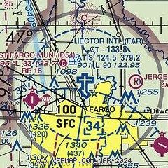
|
CAUTION: Diagram may not be current
 Download PDF
of official airport diagram from the FAA
| Airport distance calculator |
|---|
|
|
| Sunrise and sunset |
|---|
|
Times for 12-Jun-2026
| | Local
(UTC-5) | | Zulu
(UTC) |
|---|
| Morning civil twilight | | 04:54 | | 09:54 |
| Sunrise | | 05:33 | | 10:33 |
| Sunset | | 21:21 | | 02:21 |
| Evening civil twilight | | 22:01 | | 03:01 |
|
| Current date and time |
|---|
| Zulu (UTC) | 13-Jun-2026 04:42:43 |
|---|
| Local (UTC-5) | 12-Jun-2026 23:42:43 |
|---|
|
| METAR |
|---|
| KFAR | 130353Z 31008KT 10SM CLR 18/07 A2981 RMK AO2 SLP092 T01780072
|
KJKJ
8nm SE | 130415Z AUTO 31007KT 10SM CLR 17/09 A2982 RMK AO2
|
|
| TAF |
|---|
| KFAR | 121721Z 1218/1318 28020G29KT P6SM SCT050 FM130200 32010G18KT P6SM FEW050 FM131600 30018G28KT P6SM BKN025
|
|
| NOTAMs |
|---|
NOTAMs are issued by the DoD/FAA and will open in a separate window not controlled by AirNav.
|
|


