FAA INFORMATION EFFECTIVE 14 MAY 2026
Location
| FAA Identifier: | FFT |
| Lat/Long: | 38-10-54.2340N 084-54-24.3010W
38-10.903900N 084-54.405017W
38.1817317,-84.9067503
(estimated) |
| Elevation: | 812.5 ft. / 247.7 m (surveyed) |
| Variation: | 05W (2015) |
| From city: | 1 mile SW of FRANKFORT, KY |
| Time zone: | UTC -4 (UTC -5 during Standard Time) |
| Zip code: | 40601 |
Airport Operations
| Airport use: | Open to the public |
| Activation date: | 07/1954 |
| Control tower: | no |
| ARTCC: | INDIANAPOLIS CENTER |
| FSS: | LOUISVILLE FLIGHT SERVICE STATION |
| NOTAMs facility: | FFT (NOTAM-D service available) |
| Attendance: | MON-FRI 0700-2000, ALL SAT-SUN 0900-1800 |
| Wind indicator: | yes |
| Segmented circle: | yes |
| Lights: | ACTVT REIL RWY 07 & 25; PAPI RWY 07 & 25; MIRL RWY 07/25 - CTAF. |
| Beacon: | white-green (lighted land airport)
Operates sunset to sunrise. |
Airport Communications
| CTAF/UNICOM: | 122.8 |
| WX ASOS: | 119.275 (502-227-5087) |
| LEXINGTON APPROACH: | 120.75 |
| LEXINGTON DEPARTURE: | 120.75 |
| CLEARANCE DELIVERY: | 118.65 |
| WX ASOS at LEX (17 nm SE): | PHONE 859-203-5240 |
Nearby radio navigation aids
| VOR radial/distance | | VOR name | | Freq | | Var |
|---|
| FFT at field | | FRANKFORT VOR | | 109.40 | | 03W |
| HYKr302/24.2 | | LEXINGTON VOR/DME | | 112.60 | | 00E |
| IIUr081/32.0 | | LOUISVILLE VORTAC | | 114.80 | | 01E |
| FLMr229/39.7 | | FALMOUTH VOR/DME | | 117.00 | | 04W |
| NDB name | | Hdg/Dist | | Freq | | Var | | ID |
|---|
| GOODALL | | 352/36.9 | | 311 | | 03W | | DVK | -.. ...- -.- |
Airport Services
| Fuel available: | 100LL JET-A+ |
| Parking: | hangars and tiedowns |
| Airframe service: | MAJOR |
| Powerplant service: | MAJOR |
Runway Information
Runway 7/25
| Dimensions: | 5506 x 100 ft. / 1678 x 30 m |
| Surface: | asphalt, in good condition |
| Weight bearing capacity: | | PCN 29 /F/C/X/T | | Single wheel: | 76.0 | | Double wheel: | 100.0 | | Double tandem: | 82.0 |
|
| Runway edge lights: | medium intensity |
| RUNWAY 7 | | RUNWAY 25 |
| Latitude: | 38-10.704345N | | 38-11.103415N |
| Longitude: | 084-54.921027W | | 084-53.888983W |
| Elevation: | 812.5 ft. | | 783.6 ft. |
| Traffic pattern: | left | | left |
| Runway heading: | 069 magnetic, 064 true | | 249 magnetic, 244 true |
| Markings: | nonprecision, in fair condition | | nonprecision, in fair condition |
| Visual slope indicator: | 4-light PAPI on left (3.00 degrees glide path) | | 4-light PAPI on left (3.50 degrees glide path)
PAPI RWY 25 UNUSBL BYD 8 DEGS RIGHT OF CNTRLN. |
| Runway end identifier lights: | yes | | yes |
| Touchdown point: | yes, no lights | | yes, no lights |
| Instrument approach: | | | LOC/DME |
| Obstructions: | 58 ft. tree, 1684 ft. from runway, 472 ft. right of centerline, 25:1 slope to clear | | 50 ft. tree, 1721 ft. from runway, 355 ft. right of centerline, 30:1 slope to clear |
Airport Ownership and Management from official FAA records
| Ownership: | Publicly-owned |
| Owner: | COMMONWEALTH OF KENTUCKY
90 AIRPORT RD
FRANKFORT, KY 40601
Phone 502-564-3714 |
| Manager: | DREW UNDERWOOD
88 AIRPORT ROAD
FRANKFORT, KY 40601
Phone 502-564-0339
MANAGER'S CELL (502) 545-8111 |
Additional Remarks
| - | CAUTION: DANIEL BOONE HELI 1/2 NM N OF RWY 25 THR; MIL HEL TFC OPS N OF RWY. |
| - | CTC ANG OPS 42.25/139.35/226.6. |
| - | DEER & BIRDS ON & INVOF ARPT. |
| - | MIL HEL USE RIGHT BASE TO RWY 25. |
| - | PVT AP WITH TURF RWY LCTD 3/4 NM NW OF RWY 07 THR. |
| - | NOISE ABATEMENT PROCS: RWY 7 DEPG ACFT MNTN RWY HDG TO 1800 FT MSL BFR TURNING. |
| - | MILITARY: ARNG OPS - UHF FREQ 226.55 |
Instrument Procedures
NOTE: All procedures below are presented as PDF files. If you need a reader for these files, you should download the free Adobe Reader.NOT FOR NAVIGATION. Please procure official charts for flight.
FAA instrument procedures published for use from 14 May 2026 at 0901Z to 11 June 2026 at 0900Z.
IAPs - Instrument Approach Procedures |
|---|
| RNAV (GPS) RWY 07 | |
download (249KB) |
| RNAV (GPS) RWY 25 | |
download (233KB) |
| LOC RWY 25 | |
download (231KB) |
| VOR RWY 25 | |
download (176KB) |
| NOTE: Special Alternate Minimums apply | |
download (142KB) |
| NOTE: Special Take-Off Minimums/Departure Procedures apply | |
download (393KB) |
Other nearby airports with instrument procedures:
KLEX - Blue Grass Airport (17 nm SE)
27K - Georgetown-Scott County Regional Airport (22 nm E)
0I8 - Cynthiana-Harrison County Airport (31 nm E)
KBRY - Samuels Field Airport (36 nm SW)
KLOU - Bowman Field Airport (36 nm W)
|
|

Road maps at:
MapQuest
Bing
Google
| Aerial photo |
|---|
WARNING: Photo may not be current or correct
 Photo taken 27-Apr-2009
looking south.
Photo taken 27-Apr-2009
looking south.
Do you have a better or more recent aerial photo of Capital City Airport that you would like to share? If so, please send us your photo.
|
| Sectional chart |
|---|
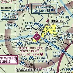
|
CAUTION: Diagram may not be current

| Airport distance calculator |
|---|
|
|
| Sunrise and sunset |
|---|
|
Times for 18-May-2026
| | Local
(UTC-4) | | Zulu
(UTC) |
|---|
| Morning civil twilight | | 05:57 | | 09:57 |
| Sunrise | | 06:27 | | 10:27 |
| Sunset | | 20:45 | | 00:45 |
| Evening civil twilight | | 21:15 | | 01:15 |
|
| Current date and time |
|---|
| Zulu (UTC) | 18-May-2026 21:45:18 |
|---|
| Local (UTC-4) | 18-May-2026 17:45:18 |
|---|
|
| METAR |
|---|
| KFFT | 182053Z AUTO A3004 RMK AO2 SLPNO 6//// 57017 PWINO PNO $
|
KLEX
17nm SE | 182054Z 19014G23KT 10SM CLR 30/16 A3006 RMK AO2 PK WND 18029/2022 SLP169 T03000156 58019
|
|
| TAF |
|---|
KLEX
17nm SE | 181723Z 1818/1918 20016G24KT P6SM SCT250 FM190000 19009KT P6SM SCT250 FM190300 18006KT P6SM BKN250 FM191400 21015G23KT P6SM BKN250
|
|
| NOTAMs |
|---|
NOTAMs are issued by the DoD/FAA and will open in a separate window not controlled by AirNav.
|
|


