FAA INFORMATION EFFECTIVE 14 MAY 2026
Location
| FAA Identifier: | FLP |
| Lat/Long: | 36-17-27.2000N 092-35-24.9000W
36-17.453333N 092-35.415000W
36.2908889,-92.5902500
(estimated) |
| Elevation: | 719.9 ft. / 219.4 m (surveyed) |
| Variation: | 00E (2020) |
| From city: | 1 mile N of FLIPPIN, AR |
| Time zone: | UTC -5 (UTC -6 during Standard Time) |
| Zip code: | 72634 |
Airport Operations
| Airport use: | Open to the public |
| Activation date: | 10/1948 |
| Control tower: | no |
| ARTCC: | MEMPHIS CENTER |
| FSS: | JONESBORO FLIGHT SERVICE STATION |
| NOTAMs facility: | FLP (NOTAM-D service available) |
| Attendance: | MON-SAT 0900-1500 |
| Wind indicator: | lighted |
| Segmented circle: | yes |
| Lights: | ACTVT REIL RWY 04, 22; PAPI RWY 04, 22; MIRL RWY 04/22 - CTAF. |
| Beacon: | white-green (lighted land airport)
Operates sunset to sunrise. |
Airport Communications
| CTAF/UNICOM: | 123.0 |
| WX AWOS-3PT: | 132.075 (870-451-0691) |
| WX ASOS at BPK (7 nm NE): | 133.975 (870-481-5946) |
- APCH/DEP SVC PRVDD BY MEMPHIS ARTCC ON FREQS 126.85/281.55 (HARRISON RCAG).
Nearby radio navigation aids
| VOR radial/distance | | VOR name | | Freq | | Var |
|---|
| HROr089/30.2 | | HARRISON VOR/DME | | 112.50 | | 04E |
Airport Services
| Fuel available: | 100LL JET-A
100LL:FUEL AVBL 24 HRS SELF SVC (100LL & JET A). |
| Parking: | tiedowns |
| Airframe service: | MINOR |
| Powerplant service: | MINOR |
| Bottled oxygen: | NONE |
| Bulk oxygen: | NONE |
Runway Information
Runway 4/22
| Dimensions: | 5001 x 75 ft. / 1524 x 23 m |
| Surface: | asphalt, in good condition |
| Weight bearing capacity: | |
| Runway edge lights: | medium intensity |
| RUNWAY 4 | | RUNWAY 22 |
| Latitude: | 36-17.195248N | | 36-17.711628N |
| Longitude: | 092-35.811953W | | 092-35.018567W |
| Elevation: | 652.3 ft. | | 719.5 ft. |
| Traffic pattern: | left | | left |
| Runway heading: | 051 | | 231 |
| Markings: | nonprecision, in good condition | | nonprecision, in good condition |
| Visual slope indicator: | 2-light PAPI on left (3.50 degrees glide path) | | 2-light PAPI on left (3.50 degrees glide path) |
| Runway end identifier lights: | yes | | yes |
| Touchdown point: | yes, no lights | | yes, no lights |
| Obstructions: | 20 ft. tree, 700 ft. from runway, 100 ft. left of centerline, 25:1 slope to clear | | 40 ft. trees, 525 ft. from runway, 180 ft. left of centerline, 8:1 slope to clear |
Airport Ownership and Management from official FAA records
| Ownership: | Publicly-owned |
| Owner: | MARION COUNTY
BOX 545
YELLVILLE, AR 72687
Phone 870-449-6231 |
| Manager: | SYLVIA HATHAWAY
954 AIRPORT 980
FLIPPIN, AR 72634
Phone 870-453-2241 |
Additional Remarks
| - | FOR CD CTC MEMPHIS ARTCC AT 901-368-8453/8449. |
| - | NO LINE OF SIGHT BTN RWY ENDS. |
| - | WILDLIFE ON & INVOF ARPT. |
Instrument Procedures
NOTE: All procedures below are presented as PDF files. If you need a reader for these files, you should download the free Adobe Reader.NOT FOR NAVIGATION. Please procure official charts for flight.
FAA instrument procedures published for use from 14 May 2026 at 0901Z to 11 June 2026 at 0900Z.
IAPs - Instrument Approach Procedures |
|---|
| RNAV (GPS) RWY 04 | |
download (257KB) |
| RNAV (GPS) RWY 22 | |
download (248KB) |
| NOTE: Special Alternate Minimums apply | |
download (23KB) |
| NOTE: Special Take-Off Minimums/Departure Procedures apply | |
download (131KB) |
Other nearby airports with instrument procedures:
KBPK - Baxter County Airport (7 nm NE)
4A5 - Searcy County Airport (24 nm S)
KHRO - Boone County Airport (27 nm W)
KBBG - Branson Airport (33 nm NW)
7M2 - Mountain View Airport-Wilcox Memorial Field (35 nm SE)
|
|

Road maps at:
MapQuest
Bing
Google
| Aerial photo |
|---|
WARNING: Photo may not be current or correct
 Photo courtesy of the Arkansas Department of Aeronautics
Taken in the Spring of 2007
Photo courtesy of the Arkansas Department of Aeronautics
Taken in the Spring of 2007
Do you have a better or more recent aerial photo of Marion County Regional Airport that you would like to share? If so, please send us your photo.
|
| Sectional chart |
|---|
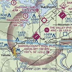
|
| Airport distance calculator |
|---|
|
|
| Sunrise and sunset |
|---|
|
Times for 10-Jun-2026
| | Local
(UTC-5) | | Zulu
(UTC) |
|---|
| Morning civil twilight | | 05:23 | | 10:23 |
| Sunrise | | 05:53 | | 10:53 |
| Sunset | | 20:26 | | 01:26 |
| Evening civil twilight | | 20:57 | | 01:57 |
|
| Current date and time |
|---|
| Zulu (UTC) | 11-Jun-2026 01:58:17 |
|---|
| Local (UTC-5) | 10-Jun-2026 20:58:17 |
|---|
|
| METAR |
|---|
KFLP
6nm E | 110056Z AUTO 17004KT 10SM CLR 29/22 A2982 RMK AO2 SLP092 T02890222
|
KBPK
8nm NE | 110153Z AUTO 21006KT 10SM CLR 27/22 A2981 RMK AO2 SLP082 T02720217 $
|
|
| TAF |
|---|
KBPK
8nm NE | 101721Z 1018/1118 21012G17KT P6SM SCT035 FM110000 20007KT P6SM SCT250 FM111500 19015G22KT P6SM BKN250
|
|
| NOTAMs |
|---|
NOTAMs are issued by the DoD/FAA and will open in a separate window not controlled by AirNav.
|
|


