FAA INFORMATION EFFECTIVE 16 APRIL 2026
Location
| FAA Identifier: | FMN |
| Lat/Long: | 36-44-28.5040N 108-13-47.7900W
36-44.475067N 108-13.796500W
36.7412511,-108.2299417
(estimated) |
| Elevation: | 5506.6 ft. / 1678.4 m (surveyed) |
| Variation: | 12E (1985) |
| From city: | 1 mile NW of FARMINGTON, NM |
| Time zone: | UTC -6 (UTC -7 during Standard Time) |
| Zip code: | 87401 |
Airport Operations
| Airport use: | Open to the public |
| Control tower: | yes |
| ARTCC: | DENVER CENTER |
| FSS: | ALBUQUERQUE FLIGHT SERVICE STATION |
| NOTAMs facility: | FMN (NOTAM-D service available) |
| Attendance: | 0600-2200 |
| Wind indicator: | lighted |
| Segmented circle: | yes |
| Lights: | WHEN ATCT CLSD ACTVT REIL RWY 23 & 25; PAPI RWY 05 & 23; VASI RWY 07 & 25; MIRL RWY 05/23 & 07/25 - CTAF. REIL RWY 25 & MIRL RWY 07/25 PRESET LOW INTST; INCR INTST - CTAF. |
| Beacon: | white-green (lighted land airport)
Operates sunset to sunrise. |
| Fire and rescue: | ARFF index A |
Airport Communications
| CTAF: | 118.9 |
| UNICOM: | 122.95 |
| ATIS: | 127.15 |
| WX ASOS: | 127.15 (505-421-0068) |
| FARMINGTON GROUND: | 121.7 [0600-2200] |
| FARMINGTON TOWER: | 118.9 257.8 [0600-2200] |
| EMERG: | 121.5 243.0 |
- APCH/DEP CTL SVC PRVDD BY DENVER ARTCC (ZDV) ON FREQS 118.575/348.7 (FARMINGTON RCAG).
Nearby radio navigation aids
| VOR radial/distance | | VOR name | | Freq | | Var |
|---|
| RSKr252/6.3 | | RATTLESNAKE VORTAC | | 115.30 | | 14E |
| DROr209/33.8 | | DURANGO VOR/DME | | 116.55 | | 14E |
Airport Services
| Fuel available: | 100LL JET-A JET-A1+ |
| Parking: | hangars and tiedowns |
| Airframe service: | MAJOR |
| Powerplant service: | MAJOR |
| Bottled oxygen: | LOW |
| Bulk oxygen: | LOW |
Runway Information
Runway 7/25
| Dimensions: | 6704 x 100 ft. / 2043 x 30 m |
| Surface: | asphalt/porous friction courses, in good condition |
| Weight bearing capacity: | | Single wheel: | 50.0 | | Double wheel: | 90.0 |
|
| Runway edge lights: | medium intensity |
| RUNWAY 7 | | RUNWAY 25 |
| Latitude: | 36-44.465593N | | 36-44.498110N |
| Longitude: | 108-14.395637W | | 108-13.023943W |
| Elevation: | 5476.9 ft. | | 5502.8 ft. |
| Traffic pattern: | left | | left |
| Runway heading: | 076 magnetic, 088 true | | 256 magnetic, 268 true |
| Displaced threshold: | 239 ft. | | 217 ft. |
| Declared distances: | TORA:6704 TODA:6704 ASDA:6487 LDA:6248 | | TORA:6704 TODA:6704 ASDA:6465 LDA:6248 |
| Markings: | precision, in good condition | | precision, in good condition |
| Visual slope indicator: | 4-box VASI on left (3.00 degrees glide path) | | 4-box VASI on left (3.00 degrees glide path) |
| Runway end identifier lights: | | | yes |
| Touchdown point: | yes, no lights | | yes, no lights |
| Instrument approach: | | | ILS/DME |
Runway 5/23
| Dimensions: | 6501 x 150 ft. / 1982 x 46 m |
| Surface: | asphalt/grooved, in excellent condition |
| Weight bearing capacity: | | Single wheel: | 47.0 | | Double wheel: | 66.0 |
|
| Runway edge lights: | medium intensity |
| RUNWAY 5 | | RUNWAY 23 |
| Latitude: | 36-44.238783N | | 36-44.697203N |
| Longitude: | 108-14.487268W | | 108-13.284470W |
| Elevation: | 5471.6 ft. | | 5503.7 ft. |
| Traffic pattern: | left | | left |
| Runway heading: | 053 magnetic, 065 true | | 233 magnetic, 245 true |
| Displaced threshold: | no | | 511 ft. |
| Declared distances: | TORA:6501 TODA:6501 ASDA:5590 LDA:5590 | | TORA:6501 TODA:6501 ASDA:6101 LDA:5590 |
| Markings: | nonprecision, in good condition | | nonprecision, in good condition |
| Visual slope indicator: | 4-light PAPI on left (3.00 degrees glide path) | | 4-light PAPI on right (3.00 degrees glide path) |
| Runway end identifier lights: | | | yes |
| Touchdown point: | yes, no lights | | yes, no lights |
Airport Ownership and Management from official FAA records
| Ownership: | Publicly-owned |
| Owner: | CITY OF FARMINGTON
800 MUNICIPAL DR
FARMINGTON, NM 87401-2663
Phone 505-599-1100 |
| Manager: | MICHAEL LEWIS
800 MUNICIPAL DR
FARMINGTON, NM 87401-2663
Phone 505-599-1394 |
Additional Remarks
| A39-05/23 | PCR VALUE: 100/F/D/X/T |
| A39-07/25 | PCR VALUE: 250/F/D/X/T |
| - | FOR CD CTC FARMINGTON ATCT GROUND CONTROL 121.7, WHEN ATCT CLSD CTC DENVER ARTCC AT 303-651-4257. |
| - | ARPT SFC CONDS UNMON OUTSIDE OF ATNDD HRS. |
Instrument Procedures
NOTE: All procedures below are presented as PDF files. If you need a reader for these files, you should download the free Adobe Reader.NOT FOR NAVIGATION. Please procure official charts for flight.
FAA instrument procedures published for use from 16 April 2026 at 0901Z to 14 May 2026 at 0900Z.
IAPs - Instrument Approach Procedures |
|---|
| ILS OR LOC RWY 25 **CHANGED** | |
download (310KB) |
| RNAV (GPS) RWY 05 **CHANGED** | |
download (258KB) |
| RNAV (GPS) RWY 07 **CHANGED** | |
download (256KB) |
| RNAV (GPS) RWY 23 **CHANGED** | |
download (300KB) |
| RNAV (GPS) RWY 25 **CHANGED** | |
download (254KB) |
| VOR/DME RWY 05 **CHANGED** | |
download (240KB) |
| VOR/DME RWY 07 **CHANGED** | |
download (245KB) |
| VOR RWY 25 **CHANGED** | |
download (246KB) |
| NOTE: Special Alternate Minimums apply | |
download (143KB) |
Departure Procedures |
|---|
| CHACO ONE | |
download (138KB) |
| PLATA ONE | |
download (164KB) |
| NOTE: Special Take-Off Minimums/Departure Procedures apply | |
download (287KB) |
Other nearby airports with instrument procedures:
KDRO - Durango-La Plata County Airport (34 nm NE)
KCEZ - Cortez Municipal Airport (39 nm NW)
KPSO - Stevens Field Airport (65 nm NE)
KTEX - Telluride Regional Airport (74 nm N)
KRQE - Window Rock Airport (77 nm SW)
|
|

Road maps at:
MapQuest
Bing
Google
| Aerial photo |
|---|
WARNING: Photo may not be current or correct
 Photo by Austin Heermann
Photo taken 30-Aug-2008
from 10,500 ft MSL looking west
Photo by Austin Heermann
Photo taken 30-Aug-2008
from 10,500 ft MSL looking west
Do you have a better or more recent aerial photo of Four Corners Regional Airport that you would like to share? If so, please send us your photo.
|
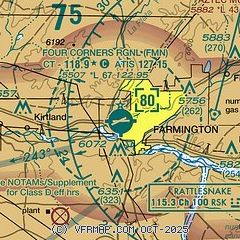
| Sectional chart |
|---|
|
| Airport distance calculator |
|---|
|
|
| Sunrise and sunset |
|---|
|
Times for 20-Apr-2026
| | Local
(UTC-6) | | Zulu
(UTC) |
|---|
| Morning civil twilight | | 06:06 | | 12:06 |
| Sunrise | | 06:33 | | 12:33 |
| Sunset | | 19:50 | | 01:50 |
| Evening civil twilight | | 20:17 | | 02:17 |
|
| Current date and time |
|---|
| Zulu (UTC) | 20-Apr-2026 22:33:57 |
|---|
| Local (UTC-6) | 20-Apr-2026 16:33:57 |
|---|
|
| METAR |
|---|
| KFMN | 202153Z 10SM CLR 26/M06 A3006 RMK AO2 SLP136 T02561061
|
|
| TAF |
|---|
| KFMN | 201726Z 2018/2118 13007KT P6SM SCT180 FM202000 26009KT P6SM SCT100 SCT180 FM210300 05006KT P6SM FEW150 FM210900 09007KT P6SM SKC
|
|
| NOTAMs |
|---|
NOTAMs are issued by the DoD/FAA and will open in a separate window not controlled by AirNav.
|
|


