FAA INFORMATION EFFECTIVE 14 MAY 2026
Location
| FAA Identifier: | CEZ |
| Lat/Long: | 37-18-10.8090N 108-37-40.9590W
37-18.180150N 108-37.682650W
37.3030025,-108.6280442
(estimated) |
| Elevation: | 5917.6 ft. / 1803.7 m (surveyed) |
| Variation: | 12E (2000) |
| From city: | 3 miles SW of CORTEZ, CO |
| Time zone: | UTC -6 (UTC -7 during Standard Time) |
| Zip code: | 81321 |
Airport Operations
| Airport use: | Open to the public |
| Activation date: | 07/1949 |
| Control tower: | no |
| ARTCC: | DENVER CENTER |
| FSS: | DENVER FLIGHT SERVICE STATION |
| NOTAMs facility: | CEZ (NOTAM-D service available) |
| Attendance: | DAWN-DUSK |
| Wind indicator: | lighted |
| Segmented circle: | yes |
| Lights: | ACTVT REIL RWY 03 & 21; MIRL RWY 03/21 - CTAF. PAPI RWY 03 & VASI RWY 21 ON CONSLY. |
| Beacon: | white-green (lighted land airport)
Operates sunset to sunrise. |
| Landing fee: | yes |
| Airline operations: | PPR FOR UNSKED ACR OPS WITH MORE THAN 30 PAX SEATS - AMGR. |
Airport Communications
| CTAF/UNICOM: | 122.8 |
| WX ASOS: | 135.625 (970-564-0193) |
- APCH/DEP CTL SVC PRVDD BY DEN ARTCC (ZDV) ON FREQS 118.575/348.7 (CORTEZ RCAG).
Nearby radio navigation aids
| VOR radial/distance | | VOR name | | Freq | | Var |
|---|
| CEZr197/6.1 | | CORTEZ VOR/DME | | 114.35 | | 14E |
| DVCr141/33.6 | | DOVE CREEK VORTAC | | 114.60 | | 14E |
Airport Services
| Fuel available: | 100LL JET-A |
| Parking: | hangars and tiedowns |
| Airframe service: | MAJOR |
| Powerplant service: | MAJOR |
| Bulk oxygen: | HIGH |
Runway Information
Runway 3/21
| Dimensions: | 7205 x 100 ft. / 2196 x 30 m |
| Surface: | asphalt/porous friction courses, in good condition |
| Weight bearing capacity: | | Single wheel: | 40.0 | | Double wheel: | 56.0 |
|
| Runway edge lights: | medium intensity |
| RUNWAY 3 | | RUNWAY 21 |
| Latitude: | 37-17.735920N | | 37-18.624353N |
| Longitude: | 108-38.175202W | | 108-37.190017W |
| Elevation: | 5913.2 ft. | | 5909.2 ft. |
| Traffic pattern: | left | | left |
| Runway heading: | 030 magnetic, 042 true | | 210 magnetic, 222 true |
| Declared distances: | TORA:7205 TODA:7205 ASDA:7205 LDA:7205 | | TORA:7205 TODA:7205 ASDA:7205 LDA:7205 |
| Markings: | nonprecision, in good condition | | nonprecision, in good condition |
| Visual slope indicator: | 4-light PAPI on left (3.00 degrees glide path) | | 4-box VASI on left (3.00 degrees glide path) |
| Runway end identifier lights: | yes | | yes |
| Touchdown point: | yes, no lights | | yes, no lights |
| Obstructions: | 59 ft. trees, 2000 ft. from runway, 350 ft. right of centerline, 30:1 slope to clear
133 FT POLE ON CNTRLN. | | 16 ft. road, 680 ft. from runway, 300 ft. right of centerline, 30:1 slope to clear |
Airport Ownership and Management from official FAA records
| Ownership: | Publicly-owned |
| Owner: | CITY OF CORTEZ
123 ROGER SMITH AVE.
CORTEZ, CO 81321
Phone (970) 565-7458 |
| Manager: | KYLE SLOAN
123 ROGER SMITH AVE.
CORTEZ, CO 81321
Phone 970-570-2980 |
Additional Remarks
| - | ACFT GTR THAN 20000 LBS DUAL WHEEL RSTRD TO TWY CONNECTOR A2; BACK TAXI ON RWY TO & FM TWY CONNECTOR A2 TO APRON. |
| - | FOR CD CTC DENVER ARTCC ON FREQ. IF UNA, CTC FSS ON FREQ VIA RCO. IF UNA, CTC DENVER ARTCC AT 303-651-4257. |
Instrument Procedures
NOTE: All procedures below are presented as PDF files. If you need a reader for these files, you should download the free Adobe Reader.NOT FOR NAVIGATION. Please procure official charts for flight.
FAA instrument procedures published for use from 14 May 2026 at 0901Z to 11 June 2026 at 0900Z.
IAPs - Instrument Approach Procedures |
|---|
| RNAV (GPS) RWY 03 | |
download (310KB) |
| RNAV (GPS) Y RWY 21 | |
download (346KB) |
| RNAV (GPS) Z RWY 21 | |
download (339KB) |
| VOR RWY 21 | |
download (319KB) |
| NOTE: Special Alternate Minimums apply | |
download (140KB) |
Departure Procedures |
|---|
| CORTEZ TWO | |
download (201KB) |
|
|---|
| LEDVE ONE (OBSTACLE) | |
download (289KB) |
| NOTE: Special Take-Off Minimums/Departure Procedures apply | |
download (105KB) |
Other nearby airports with instrument procedures:
KFMN - Four Corners Regional Airport (39 nm SE)
KDRO - Durango-La Plata County Airport (43 nm E)
KBDG - Blanding Municipal Airport (44 nm NW)
U64 - Monticello Airport (51 nm NW)
KTEX - Telluride Regional Airport (52 nm NE)
|
|

Road maps at:
MapQuest
Bing
Google
| Aerial photo |
|---|
WARNING: Photo may not be current or correct
 Photo by Austin Heermann
Photo taken 30-Aug-2008
Photo by Austin Heermann
Photo taken 30-Aug-2008
Do you have a better or more recent aerial photo of Cortez Municipal Airport that you would like to share? If so, please send us your photo.
|
| Sectional chart |
|---|
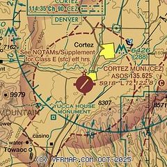
|
| Airport distance calculator |
|---|
|
|
| Sunrise and sunset |
|---|
|
Times for 07-Jun-2026
| | Local
(UTC-6) | | Zulu
(UTC) |
|---|
| Morning civil twilight | | 05:24 | | 11:24 |
| Sunrise | | 05:55 | | 11:55 |
| Sunset | | 20:32 | | 02:32 |
| Evening civil twilight | | 21:03 | | 03:03 |
|
| Current date and time |
|---|
| Zulu (UTC) | 07-Jun-2026 09:31:08 |
|---|
| Local (UTC-6) | 07-Jun-2026 03:31:08 |
|---|
|
| METAR |
|---|
| KCEZ | 070853Z AUTO 21017KT 10SM CLR 22/M05 A2994 RMK AO2 PK WND 21027/0831 SLP033 T02221050 51006
|
|
| TAF |
|---|
KFMN
38nm SE | 070522Z 0706/0806 VRB06KT P6SM FEW250 FM071700 27008KT P6SM SCT200 FM071900 26015G25KT P6SM SCT150 FM080200 25010KT P6SM BKN200
|
KDRO
42nm E | 070541Z 0706/0806 32005KT P6SM SKC FM071600 26015G24KT P6SM FEW120 FM080000 27018G25KT P6SM FEW120 BKN250 FM080300 27005KT P6SM BKN250
|
|
| NOTAMs |
|---|
NOTAMs are issued by the DoD/FAA and will open in a separate window not controlled by AirNav.
|
|

