FAA INFORMATION EFFECTIVE 22 JANUARY 2026
Location
| FAA Identifier: | FTK |
| Lat/Long: | 37-54-25.4350N 085-58-19.3300W
37-54.423917N 085-58.322167W
37.9070653,-85.9720361
(estimated) |
| Elevation: | 754.3 ft. / 229.9 m (surveyed) |
| Variation: | 03W (1995) |
| From city: | 1 mile W of FORT KNOX, KY |
| Time zone: | UTC -5 (UTC -4 during Daylight Saving Time) |
| Zip code: | 40121 |
Airport Operations
| Airport use: | Private use. Permission required prior to landing |
| Activation date: | 05/1941 |
| Control tower: | yes |
| ARTCC: | INDIANAPOLIS CENTER |
| FSS: | LOUISVILLE FLIGHT SERVICE STATION |
| NOTAMs facility: | FTK (NOTAM-D service available) |
| Attendance: | CONTINUOUS
SEE FLIP AP/1 SUPPLEMENTARY ARPT RMK. |
| Pattern altitude: | TPA W OF AIRFIELD: 1500 FT AGL ROTARY WING, 2300 FT AGL FIXED WING, 2300 FT OVHD. |
| Segmented circle: | no |
| Lights: | ACTVT SSALR RWY 18; ODALS RWY 36; REIL RWY 18; PAPI RWY 18 & 36; HIRL 18/36 - CTAF. 0400-1200Z++. |
| Beacon: | white-white-green (lighted military airport)
ROTG BCN LCTD ON ATCT. Operates sunset to sunrise. |
Airport Communications
| CTAF: | 133.35 |
| ATIS: | 109.6 |
| GODMAN GROUND: | 121.9 239.3 [1230-0400Z++ MON-SAT; CLSD WKENDS & HOL. CONTACT GODMAN ADVISORY.] |
| GODMAN TOWER: | 133.35 233.7 [1230-0400Z++ MON-SAT; CLSD WKENDS & HOL. CONTACT GODMAN ADVISORY.] |
| LOUISVILLE APPROACH: | 123.675 |
| LOUISVILLE DEPARTURE: | 123.675 |
| EMERG: | 121.5 243.0 |
| OPS: | 126.2 234.4 |
| PMSV METRO: | 139.65 |
| PTD: | 126.2 234.4 |
| WX AWOS-3 at EKX (13 nm S): | 118.55 (270-763-6433) |
| WX ASOS at SDF (20 nm NE): | PHONE 502-676-6814 |
- FT CAMPBELL FLT COORD CENTER FREQS 242.4; 139.3; AND 46.80.
- FULL SVC DURG FCST HR.
Nearby radio navigation aids
| VOR radial/distance | | VOR name | | Freq | | Var |
|---|
| FTK at field | | FORT KNOX VOR/DME | | 109.60 | | 01W |
| MYSr088/(12.9) | | MYSTIC VOR | | 108.20 | | 01W |
| EWOr319/21.7 | | NEW HOPE VOR/DME | | 113.95 | | 01E |
| IIUr237/22.1 | | LOUISVILLE VORTAC | | 114.80 | | 01E |
| NDB name | | Hdg/Dist | | Freq | | Var | | ID |
|---|
| GODMAN | | 179/3.1 | | 396 | | 03W | | GOI | --. --- .. |
Airport Services
| Fuel available: | A++
A++:MIL; AVBL 1200-0400Z++ MON-SAT AND 1ST & 3RD SUN, CLSD REMAINING SUN & HOL; REQ FUEL SVC 502-624-7763/2763 WHEN ALFD OPS & TWR CLSD. |
| Oil available: | 233.7 |
Runway Information
Runway 18/36
| Dimensions: | 5184 x 150 ft. / 1580 x 46 m |
| Surface: | asphalt |
| Weight bearing capacity: | |
| Runway edge lights: | high intensity |
| RUNWAY 18 | | RUNWAY 36 |
| Latitude: | 37-54.850970N | | 37-53.998342N |
| Longitude: | 085-58.218713W | | 085-58.155262W |
| Elevation: | 753.6 ft. | | 727.6 ft. |
| Traffic pattern: | left | | left |
| Markings: | nonprecision, in good condition | | nonprecision, in good condition |
| Visual slope indicator: | 4-light PAPI on left (3.00 degrees glide path) | | 4-light PAPI on left (3.00 degrees glide path) |
| Approach lights: | SSALR: simplified short approach lighting system with runway alignment indicator lights | | ODALS: omnidirectional approach lighting system |
| Runway end identifier lights: | yes | | |
| Touchdown point: | yes, no lights | | yes, no lights |
| Instrument approach: | ILS/DME | | |
Runway 15/33
| Dimensions: | 4853 x 75 ft. / 1479 x 23 m |
| Surface: | asphalt |
| Weight bearing capacity: | |
| Runway edge lights: | medium intensity |
| RUNWAY 15 | | RUNWAY 33 |
| Latitude: | 37-54.763060N | | 37-54.083183N |
| Longitude: | 085-58.732102W | | 085-58.201105W |
| Elevation: | 754.3 ft. | | 729.7 ft. |
| Traffic pattern: | left | | left |
| Markings: | nonprecision, in good condition | | nonprecision, in good condition |
| Runway end identifier lights: | yes | | yes |
| Touchdown point: | yes, no lights | | yes, no lights |
Airport Ownership and Management from official FAA records
| Ownership: | U.S. Army |
| Owner: | US ARMY ATCA-ASO
CAMERON STA
ALEXANDRIA, VA 22314 |
| Manager: | RICKEY WEBB
Phone 502-624-5737 |
Additional Remarks
| - | DEER & COYOTE INVOF ARPT SPCLY 1 HR PRIOR SR & SS. |
| - | MISC: ALL WX FCST PMSV BRIEFINGS & SUPPORT 1100-0400++ MON-FRI; CLSD WKEND & HOL. OTR TIMES - SCOTT OWS D576-9755/9702/C618-256-9755/9702; HTTPS://15OWS.US.AF.MIL WX OBS AUTO & AUGMENTED. |
| - | TSNT ACFT PRKG ON GREEN RAMP UNLESS ALTN PRKG COORD. C-130 & LRGR PARK ON CONC PAD BTW TWY A & B. |
| - | MISC: RANGE INFO - 38.90; 136.075. |
| - | MISC: IR LGT INSTL APCH END RWY 15 ASSAULT STRIP. |
| - | SEE FLIP AP/1 & FT KNOX REG 95-1 SUPPLEMENTARY ARPT INFO. |
| - | RSTD: PPR FOR TSNT - D464-5536/C502-624-5536; VIP CTC OPS 20 MIN PRIOR TO LDG. |
| - | COMM: AIR TO AIR UHF 237.5 WI FORT KNOX ASP. |
| - | COMM: PTD OPS 1230-2100Z++ MON-FRI; CLSD HOL. PTD - 126.2, 234.4; ATIS - 109.6; LOUSIVILLE APP/DEP 132.075, 327.0. |
| - | AIRFIELD OPS 126.2, 234.4; 1230-2100Z++ MON-FRI; CLSD HOL. FICON & VEHICLE ACES TO FLIGHTLINE UNAVBL WHEN AIRFIELD OPS CLSD. |
| - | NON-MOV AREA RED, BLUE, YELLOW, GOLD & TWY D FM BLUE RAMP TO POINT NORTH. |
| - | TRANS ALERT SVC NOT AVBL. |
| - | NO SHOULDERS RWY 18/36, 15/33, TWY B, C, D & G. TWY F UNLGT. |
| - | MISC: RWY 33 & 36 CLEAR ZONES NSTD. |
| - | WHEN TWR & AIRFIELD OPS CLSD USE 126.2 FOR IFR/SVFR CLNCS, RELEASES & ARR. IF UNBL CTC LOUISVILLE APP/DEP C502-375-7499. |
| - | CTN: RAILROAD CROSSES NW - SE 625 FT FM AER 18 CNTRLN; ILS APCH RWY 18 & FIXED WING DEP RWY 36 NA WHEN RAIL CARS PRESENT. FENCE 565 FT FM AER 18. RSTD AREA 1 NM E OF ARPT. OVERFLIGHT OF GOLD DEPOSITORY 1 NM S OF RWY 36 NA. EXTV UAS OPS IN CLASS D & R3704A/B. R/W AIRCREWS PLANNING OPS WI R3704A MUST RCV RANGE BRIEFING PRIOR TO OPS. |
| - | RSTD: TWY D RSTRD TO R/W ONLY. |
Instrument Procedures
NOTE: All procedures below are presented as PDF files. If you need a reader for these files, you should download the free Adobe Reader.NOT FOR NAVIGATION. Please procure official charts for flight.
FAA instrument procedures published for use from 22 January 2026 at 0901Z to 19 February 2026 at 0900z.
IAPs - Instrument Approach Procedures |
|---|
| ILS OR LOC/DME RWY 18 | |
download (175KB) |
| RNAV (GPS) RWY 15 | |
download (152KB) |
| RNAV (GPS) RWY 18 | |
download (187KB) |
| RNAV (GPS) RWY 36 | |
download (146KB) |
| VOR/DME RWY 15 | |
download (158KB) |
| VOR/DME RWY 18 | |
download (169KB) |
| VOR/DME RWY 36 | |
download (165KB) |
| NOTE: Special Take-Off Minimums/Departure Procedures apply | |
download (370KB) |
Other nearby airports with instrument procedures:
KEKX - Addington Field Airport (13 nm S)
KSDF - Louisville Muhammad Ali International Airport (20 nm NE)
KBRY - Samuels Field Airport (23 nm E)
I93 - Breckinridge County Airport (23 nm W)
KLOU - Bowman Field Airport (24 nm NE)
|
|

Road maps at:
MapQuest
Bing
Google
| Aerial photo |
|---|
WARNING: Photo may not be current or correct

Do you have a better or more recent aerial photo of Godman Army Airfield that you would like to share? If so, please send us your photo.
|
| Sectional chart |
|---|
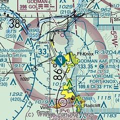
|
| Airport distance calculator |
|---|
|
|
| Sunrise and sunset |
|---|
|
Times for 08-Feb-2026
| | Local
(UTC-5) | | Zulu
(UTC) |
|---|
| Morning civil twilight | | 07:15 | | 12:15 |
| Sunrise | | 07:43 | | 12:43 |
| Sunset | | 18:14 | | 23:14 |
| Evening civil twilight | | 18:41 | | 23:41 |
|
| Current date and time |
|---|
| Zulu (UTC) | 08-Feb-2026 06:53:31 |
|---|
| Local (UTC-5) | 08-Feb-2026 01:53:31 |
|---|
|
| METAR |
|---|
| KFTK | 080555Z AUTO 06004KT 10SM BKN140 OVC170 M05/M13 A3035 RMK AO2 SLP289 T10501129 11031 21062 55007 $
|
KEKX
12nm SE | 080635Z AUTO 08004KT 10SM CLR M05/M13 A3035 RMK AO2 T10531129
|
|
| NOTAMs |
|---|
NOTAMs are issued by the DoD/FAA and will open in a separate window not controlled by AirNav.
|
|

