FAA INFORMATION EFFECTIVE 16 APRIL 2026
Location
| FAA Identifier: | GGE |
| Lat/Long: | 33-18-41.1000N 079-19-13.1000W
33-18.685000N 079-19.218333W
33.3114167,-79.3203056
(estimated) |
| Elevation: | 39.5 ft. / 12.0 m (surveyed) |
| Variation: | 08W (2015) |
| From city: | 3 miles S of GEORGETOWN, SC |
| Time zone: | UTC -4 (UTC -5 during Standard Time) |
| Zip code: | 29440 |
Airport Operations
| Airport use: | Open to the public |
| Activation date: | 06/1944 |
| Control tower: | no |
| ARTCC: | JACKSONVILLE CENTER |
| FSS: | ANDERSON FLIGHT SERVICE STATION |
| NOTAMs facility: | GGE (NOTAM-D service available) |
| Attendance: | 0700-2100 |
| Wind indicator: | lighted |
| Segmented circle: | yes |
| Lights: | ACTVT RY 5/23 MIRL, PAPI RY 5 & RY 23, REIL RY 05 AND ODALS RY 05 0300-1000 - CTAF. |
| Beacon: | white-green (lighted land airport)
Operates sunset to sunrise. |
Airport Communications
| CTAF/UNICOM: | 123.0 |
| WX AWOS-3: | 118.275 (843-527-3851) |
| MYRTLE BEACH APPROACH: | 127.4 [0630-2200] |
| MYRTLE BEACH DEPARTURE: | 127.4 [0630-2200] |
- APCH/DEP SVC PRVDD BY JACKSONVILLE ARTCC ON FREQS 134.375/317.550 (MYRTLE BEACH RCAG) WHEN MYRTLE BEACH APCH CTL CLSD.
Nearby radio navigation aids
| NDB name | | Hdg/Dist | | Freq | | Var | | ID |
|---|
| EVANS | | 152/39.5 | | 420 | | 06W | | CFY | -.-. ..-. -.-- |
Airport Services
| Fuel available: | 100LL JET-A |
| Parking: | hangars and tiedowns |
| Airframe service: | MAJOR |
| Powerplant service: | MAJOR |
| Bottled oxygen: | HIGH |
Runway Information
Runway 5/23
| Dimensions: | 6005 x 100 ft. / 1830 x 30 m |
| Surface: | asphalt, in excellent condition |
| Weight bearing capacity: | | Single wheel: | 40.0 | | Double wheel: | 60.0 |
|
| Runway edge lights: | medium intensity |
| RUNWAY 5 | | RUNWAY 23 |
| Latitude: | 33-18.451797N | | 33-19.194577N |
| Longitude: | 079-19.705243W | | 079-18.925452W |
| Elevation: | 39.5 ft. | | 33.5 ft. |
| Traffic pattern: | left | | left |
| Runway heading: | 049 magnetic, 041 true | | 229 magnetic, 221 true |
| Markings: | nonprecision, in good condition | | nonprecision, in good condition |
| Visual slope indicator: | 2-light PAPI on left (3.00 degrees glide path) | | 2-light PAPI on left (3.00 degrees glide path) |
| Approach lights: | ODALS: omnidirectional approach lighting system | | |
| Runway end identifier lights: | yes | | |
| Touchdown point: | yes, no lights | | yes, no lights |
| Obstructions: | none | | 68 ft. tree, 2149 ft. from runway, 349 ft. right of centerline, 28:1 slope to clear |
Runway 11/29
| Dimensions: | 4539 x 150 ft. / 1383 x 46 m |
| Surface: | asphalt, in fair condition
RWY SFC IS VERY RUF WITH GRASS GROWING THRU THE CRACKS. |
| Weight bearing capacity: | | Single wheel: | 20.0 | | Double wheel: | 30.0 |
|
| Runway edge lights: | medium intensity |
| RUNWAY 11 | | RUNWAY 29 |
| Latitude: | 33-18.574292N | | 33-18.425962N |
| Longitude: | 079-19.528242W | | 079-18.654558W |
| Elevation: | 37.2 ft. | | 23.0 ft. |
| Traffic pattern: | left | | left |
| Runway heading: | 109 magnetic, 101 true | | 289 magnetic, 281 true |
| Markings: | basic, in good condition | | basic, in good condition |
| Touchdown point: | yes, no lights | | yes, no lights |
| Obstructions: | none | | 104 ft. tree, 1408 ft. from runway, 38 ft. right of centerline, 11:1 slope to clear |
Airport Ownership and Management from official FAA records
| Ownership: | Publicly-owned |
| Owner: | GEORGETOWN COUNTY
PO DRAWER 421270
GEORGETOWN, SC 29440
Phone 843-546-4189 |
| Manager: | JIM TAYLOR
129 AIRPORT RD.
GEORGETOWN, SC 29440
Phone 843-545-3638
FAX NUMBER 843-545-3413 |
Additional Remarks
| A39-05/23 | PCR VALUE: 220/F/A/X/T |
| - | GCO AVBL ON FREQ 121.725 THRU MYR CD. |
| - | RY 11/29 CLSD TO ACFT 12,500 LBS & OVER. |
| - | FOR CD IF UNA VIA GCO CTC JACKSONVILLE ARTCC AT 904-845-1592. |
Instrument Procedures
NOTE: All procedures below are presented as PDF files. If you need a reader for these files, you should download the free Adobe Reader.NOT FOR NAVIGATION. Please procure official charts for flight.
FAA instrument procedures published for use from 16 April 2026 at 0901Z to 14 May 2026 at 0900Z.
IAPs - Instrument Approach Procedures |
|---|
| RNAV (GPS) RWY 05 | |
download (240KB) |
| RNAV (GPS) RWY 23 | |
download (233KB) |
| NOTE: Special Alternate Minimums apply | |
download (64KB) |
| NOTE: Special Take-Off Minimums/Departure Procedures apply | |
download (387KB) |
Other nearby airports with instrument procedures:
KPHH - Robert F Swinnie Airport (13 nm NW)
KMYR - Myrtle Beach International Airport (30 nm NE)
KHYW - Conway-Horry County Airport (33 nm N)
KLRO - Mount Pleasant Regional Airport-Faison Field (34 nm SW)
KCKI - Williamsburg Regional Airport (36 nm NW)
|
|

Road maps at:
MapQuest
Bing
Google
| Aerial photo |
|---|
WARNING: Photo may not be current or correct

Do you have a better or more recent aerial photo of Georgetown County Airport that you would like to share? If so, please send us your photo.
|
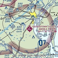
| Sectional chart |
|---|
|
| Airport distance calculator |
|---|
|
|
| Sunrise and sunset |
|---|
|
Times for 25-Apr-2026
| | Local
(UTC-4) | | Zulu
(UTC) |
|---|
| Morning civil twilight | | 06:10 | | 10:10 |
| Sunrise | | 06:37 | | 10:37 |
| Sunset | | 19:54 | | 23:54 |
| Evening civil twilight | | 20:20 | | 00:20 |
|
| Current date and time |
|---|
| Zulu (UTC) | 25-Apr-2026 12:08:17 |
|---|
| Local (UTC-4) | 25-Apr-2026 08:08:17 |
|---|
|
| METAR |
|---|
| KGGE | 251155Z AUTO 22003KT 10SM CLR 18/18 A2986 RMK AO2
|
|
| TAF |
|---|
KMYR
29nm NE | 251120Z 2512/2612 23007KT P6SM FEW200 FM251600 18014G20KT P6SM FEW050 BKN200 FM260100 20010KT P6SM BKN090 PROB30 2602/2606 6SM -TSRA OVC040CB FM260800 32005KT 6SM -SHRA BR OVC030
|
|
| NOTAMs |
|---|
NOTAMs are issued by the DoD/FAA and will open in a separate window not controlled by AirNav.
|
|

