FAA INFORMATION EFFECTIVE 16 APRIL 2026
Location
| FAA Identifier: | GHW |
| Lat/Long: | 45-38-37.7885N 095-19-13.6161W
45-38.629808N 095-19.226935W
45.6438301,-95.3204489
(estimated) |
| Elevation: | 1393.9 ft. / 424.9 m (surveyed) |
| Variation: | 04E (2000) |
| From city: | 3 miles E of GLENWOOD, MN |
| Time zone: | UTC -5 (UTC -6 during Standard Time) |
| Zip code: | 56334 |
Airport Operations
| Airport use: | Open to the public |
| Activation date: | 06/1938 |
| Control tower: | no |
| ARTCC: | MINNEAPOLIS CENTER |
| FSS: | PRINCETON FLIGHT SERVICE STATION |
| NOTAMs facility: | GHW (NOTAM-D service available) |
| Attendance: | MON-FRI 0800-1530 |
| Wind indicator: | lighted |
| Segmented circle: | no |
| Lights: | MIRL RY 15/33 PRESET LOW INTST; TO INCREASE INTST AND ACTIVATE PAPI RY 15 AND 33 - CTAF. |
| Beacon: | white-green (lighted land airport)
Operates sunset to sunrise. |
Airport Communications
| CTAF: | 122.9 |
| WX AWOS-3: | 118.925 (320-634-5660) |
| WX ASOS at AXN (14 nm N): | 118.375 (320-763-7174) |
| WX AWOS-3 at D39 (17 nm E): | 118.475 (320-352-0136) |
- APCH/DEP SVC PRVDD BY MINNEAPOLIS ARTCC ON FREQS 126.1/269.2 (ALEXANDRIA RCAG).
Nearby radio navigation aids
| VOR radial/distance | | VOR name | | Freq | | Var |
|---|
| AXNr184/19.2 | | ALEXANDRIA VOR/DME | | 115.95 | | 07E |
| MOXr075/27.6 | | MORRIS VOR/DME | | 109.60 | | 05E |
| BDHr342/32.6 | | WILLMAR VOR/DME | | 113.70 | | 04E |
Airport Services
| Fuel available: | 100LL
100LL:SELF SVC FUEL AVBL 24 HR WITH CREDIT CARD. |
| Parking: | hangars and tiedowns |
| Airframe service: | NONE |
| Powerplant service: | NONE |
| Bottled oxygen: | NONE |
| Bulk oxygen: | NONE |
Runway Information
Runway 15/33
| Dimensions: | 4500 x 75 ft. / 1372 x 23 m |
| Surface: | asphalt, in good condition |
| Runway edge lights: | medium intensity |
| RUNWAY 15 | | RUNWAY 33 |
| Latitude: | 45-38.888977N | | 45-38.184248N |
| Longitude: | 095-19.376603W | | 095-19.053067W |
| Elevation: | 1390.9 ft. | | 1376.7 ft. |
| Traffic pattern: | left | | left |
| Runway heading: | 158 magnetic, 162 true | | 338 magnetic, 342 true |
| Markings: | nonprecision, in good condition | | nonprecision, in good condition |
| Visual slope indicator: | 4-light PAPI on left (3.00 degrees glide path) | | 4-light PAPI on left (3.00 degrees glide path) |
| Runway end identifier lights: | no | | no |
| Touchdown point: | yes, no lights | | yes, no lights |
Runway 5/23
| Dimensions: | 2778 x 196 ft. / 847 x 60 m |
| Surface: | turf, in good condition |
| Runway edge markings: | RWY 05-23 MARKED WITH YELLOW CONES |
| RUNWAY 5 | | RUNWAY 23 |
| Latitude: | 45-38.658263N | | 45-38.903287N |
| Longitude: | 095-19.521625W | | 095-18.971443W |
| Elevation: | 1393.9 ft. | | 1393.5 ft. |
| Traffic pattern: | left | | left |
| Runway heading: | 054 magnetic, 058 true | | 234 magnetic, 238 true |
| Markings: | NSTD | | NSTD |
| Runway end identifier lights: | no | | no |
| Touchdown point: | yes, no lights | | yes, no lights |
| Obstructions: | 8 ft. other, 139 ft. from runway, 78 ft. right of centerline, 17:1 slope to clear
IRRIGATION BOOM. | | none |
Airport Ownership and Management from official FAA records
| Ownership: | Publicly-owned |
| Owner: | CITY OF GLENWOOD
137 E MINNESOTA
GLENWOOD, MN 56334
Phone 320-634-5433 |
| Manager: | DAVID IVERSON
137 E. MINNESOTA AVE
GLENWOOD, MN 56334
Phone 320-634-5433 |
Additional Remarks
| - | RY 05/23 NOT PLOWED WINTER MONTHS. |
| - | DEER ON & INVOF ARPT. |
| - | GCO AVBL ON FREQ 121.725 THRU MINNEAPOLIS ARTCC & FLT SVCS. |
| - | FOR CD IF UNA VIA GCO CTC MINNEAPOLIS ARTCC AT 651-463-5588. |
Instrument Procedures
NOTE: All procedures below are presented as PDF files. If you need a reader for these files, you should download the free Adobe Reader.NOT FOR NAVIGATION. Please procure official charts for flight.
FAA instrument procedures published for use from 16 April 2026 at 0901Z to 14 May 2026 at 0900Z.
IAPs - Instrument Approach Procedures |
|---|
| RNAV (GPS) RWY 15 | |
download (234KB) |
| RNAV (GPS) RWY 33 | |
download (241KB) |
| VOR RWY 33 | |
download (215KB) |
| NOTE: Special Alternate Minimums apply | |
download (45KB) |
| NOTE: Special Take-Off Minimums/Departure Procedures apply | |
download (156KB) |
Other nearby airports with instrument procedures:
KAXN - Alexandria Regional Airport/Chandler Field (14 nm N)
D39 - Sauk Centre Municipal Airport (17 nm E)
KBBB - Benson Municipal Airport (23 nm SW)
14Y - Todd Field Airport (24 nm NE)
KMOX - Morris Municipal Airport - Charlie Schmidt Field (27 nm W)
|
|

Road maps at:
MapQuest
Bing
Google
| Aerial photo |
|---|
WARNING: Photo may not be current or correct
 Photo by Nick Tognacci
Photo taken 04-May-2014
from 5500 feet looking north.
Photo by Nick Tognacci
Photo taken 04-May-2014
from 5500 feet looking north.
Do you have a better or more recent aerial photo of Glenwood Municipal Airport that you would like to share? If so, please send us your photo.
|
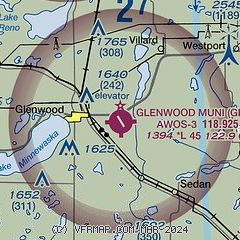
| Sectional chart |
|---|
|
| Airport distance calculator |
|---|
|
|
| Sunrise and sunset |
|---|
|
Times for 08-May-2026
| | Local
(UTC-5) | | Zulu
(UTC) |
|---|
| Morning civil twilight | | 05:26 | | 10:26 |
| Sunrise | | 06:00 | | 11:00 |
| Sunset | | 20:36 | | 01:36 |
| Evening civil twilight | | 21:09 | | 02:09 |
|
| Current date and time |
|---|
| Zulu (UTC) | 08-May-2026 19:28:38 |
|---|
| Local (UTC-5) | 08-May-2026 14:28:38 |
|---|
|
| METAR |
|---|
| KGHW | 081915Z AUTO 25015G19KT 10SM FEW100 20/M03 A2963 RMK AO2 T02041030 $
|
KAXN
14nm N | 081853Z AUTO 28013G20KT 10SM FEW095 20/M06 A2965 RMK AO2 SLP044 T02001061
|
KD39
17nm E | 081915Z AUTO 25011G18KT 10SM SCT100 19/M04 A2964 RMK AO2 T01871042
|
|
| TAF |
|---|
KAXN
14nm N | 081732Z 0818/0918 28010KT P6SM SCT120 FM082100 29017G25KT P6SM FEW250 FM090200 32008KT P6SM FEW250 PROB30 0906/0910 4SM -SHRA OVC035 FM091300 35011G19KT P6SM SCT100
|
|
| NOTAMs |
|---|
NOTAMs are issued by the DoD/FAA and will open in a separate window not controlled by AirNav.
|
|

