FAA INFORMATION EFFECTIVE 14 MAY 2026
Location
| FAA Identifier: | GLS |
| Lat/Long: | 29-15-55.2000N 094-51-37.5000W
29-15.920000N 094-51.625000W
29.2653333,-94.8604167
(estimated) |
| Elevation: | 5.6 ft. / 1.7 m (surveyed) |
| Variation: | 02E (2015) |
| From city: | 3 miles SW of GALVESTON, TX |
| Time zone: | UTC -5 (UTC -6 during Standard Time) |
| Zip code: | 77554 |
Airport Operations
| Airport use: | Open to the public |
| Activation date: | 08/1938 |
| Control tower: | yes |
| ARTCC: | HOUSTON CENTER |
| FSS: | MONTGOMERY COUNTY FLIGHT SERVICE STATION |
| NOTAMs facility: | GLS (NOTAM-D service available) |
| Attendance: | 0600-2000 |
| Wind indicator: | lighted |
| Segmented circle: | yes |
| Lights: | HIRL RWY 14/32, MIRL RWY 18/36 PRESET ON MED INTST. TO INCR INTST & ACTVT MALSR RWY 14 - CTAF. PAPI RWYS 14, 18, 32 & 36 OPR CONSLY. |
| Beacon: | white-green (lighted land airport)
Operates sunset to sunrise. |
| International operations: | customs landing rights airport |
Airport Communications
| CTAF: | 120.575 |
| UNICOM: | 123.05 |
| WX ASOS: | 123.950 (409-740-5483) |
| GALVESTON GROUND: | 118.625 [0600-1800] |
| GALVESTON TOWER: | 120.575 [0600-1800] |
| HOUSTON APPROACH: | 134.45 |
| HOUSTON DEPARTURE: | 134.45 |
| CLEARANCE DELIVERY: | 135.35 ;WHEN TWR CLSD |
| ALEXANDRIA DP: | 134.45 |
| BLTWY RNAV DP: | 134.45 |
| BLUBELL STAR: | 124.225 |
| BORRN RNAV DP: | 134.45 |
| CESAN STAR: | 121.3 |
| CRIED DP: | 134.45 |
| DREMR DP: | 134.45 |
| EL DORADO DP: | 134.45 |
| GIFFA DP: | 134.45 |
| HOODO RNAV DP: | 134.45 |
| HUDZY STAR: | 120.05 |
| INDIE RNAV DP: | 134.45 |
| KARRR RNAV DP: | 134.45 |
| LEONA DP: | 134.45 |
| LUFKIN DP: | 134.45 |
| LURIC DP: | 134.45 |
| MMALT RNAV DP: | 134.45 |
| OHIIO STAR: | 120.05 |
| STRYA DP: | 134.45 |
| STYCK DP: | 134.45 |
| TKNIQ STAR: | 119.625 |
| TRUAX DP: | 134.45 |
| TSHIRT STAR: | 119.175 |
| TSHRT STAR: | 119.175 |
| WAPPL STAR: | 120.05 |
| WATFO DP: | 134.45 |
| WYLSN RNAV DP: | 134.45 |
Nearby radio navigation aids
| VOR radial/distance | | VOR name | | Freq | | Var |
|---|
| VUH at field | | SCHOLES VOR/DME | | 113.00 | | 06E |
| MHFr192/17.9 | | TRINITY VOR/DME | | 114.75 | | 07E |
Airport Services
| Fuel available: | 100LL JET-A+
100LL:AFT HRS SVC 409-750-0195. |
| Parking: | hangars and tiedowns |
| Airframe service: | MAJOR |
| Powerplant service: | MAJOR |
| Bottled oxygen: | NONE |
| Bulk oxygen: | NONE |
Runway Information
Runway 18/36
| Dimensions: | 6001 x 150 ft. / 1829 x 46 m |
| Surface: | concrete, in good condition |
| Weight bearing capacity: | | Single wheel: | 74.0 | | Double wheel: | 92.0 | | Double tandem: | 162.0 |
|
| Runway edge lights: | medium intensity |
| RUNWAY 18 | | RUNWAY 36 |
| Latitude: | 29-16.410232N | | 29-15.420192N |
| Longitude: | 094-51.544178W | | 094-51.561075W |
| Elevation: | 5.6 ft. | | 4.6 ft. |
| Traffic pattern: | left | | left |
| Runway heading: | 179 magnetic, 181 true | | 359 magnetic, 001 true |
| Declared distances: | TORA:6001 TODA:6001 ASDA:6001 LDA:6001 | | TORA:6001 TODA:6001 ASDA:6001 LDA:6001 |
| Markings: | nonprecision, in good condition | | nonprecision, in good condition |
| Visual slope indicator: | 4-light PAPI on left (3.00 degrees glide path) | | 4-light PAPI on left (3.00 degrees glide path) |
| Runway end identifier lights: | yes | | yes |
| Touchdown point: | yes, no lights | | yes, no lights |
| Obstructions: | none | | 120 ft. bldg, 2970 ft. from runway, 240 ft. right of centerline, 23:1 slope to clear |
Runway 14/32
| Dimensions: | 6000 x 150 ft. / 1829 x 46 m |
| Surface: | asphalt/concrete, in good condition
FIRST 1300 FT NW END IS CONC. |
| Weight bearing capacity: | | Single wheel: | 90.0 | | Double wheel: | 115.0 | | Double tandem: | 192.0 |
|
| Runway edge lights: | high intensity |
| RUNWAY 14 | | RUNWAY 32 |
| Latitude: | 29-16.303015N | | 29-15.543382N |
| Longitude: | 094-52.058840W | | 094-51.334838W |
| Elevation: | 5.3 ft. | | 4.6 ft. |
| Traffic pattern: | left | | left |
| Runway heading: | 138 magnetic, 140 true | | 318 magnetic, 320 true |
| Declared distances: | TORA:6000 TODA:6000 ASDA:6000 LDA:6000 | | TORA:6000 TODA:6000 ASDA:5819 LDA:5819 |
| Markings: | precision, in good condition | | precision, in good condition |
| Visual slope indicator: | 4-light PAPI on left (3.00 degrees glide path) | | 4-light PAPI on left (3.00 degrees glide path) |
| Approach lights: | MALSR: 1,400 foot medium intensity approach lighting system with runway alignment indicator lights | | |
| Runway end identifier lights: | | | yes |
| Touchdown point: | yes, no lights | | yes, no lights |
| Instrument approach: | ILS | | |
| Obstructions: | none | | 80 ft. bldg, 2492 ft. from runway, 130 ft. left of centerline, 28:1 slope to clear |
Airport Ownership and Management from official FAA records
| Ownership: | Publicly-owned |
| Owner: | CITY OF GALVESTON
PO BOX 779
GALVESTON, TX 77552
Phone 409-797-3590 |
| Manager: | MIKE SHAHAN
2115 TERMINAL DRIVE
GALVESTON, TX 77554
Phone 409-797-3590 |
Additional Remarks
| - | FLOCKS OF BIRDS INVOF ARPT BLW 200 FT AGL. |
| - | FOR CD WHEN ATCT IS CLSD CTC HOUSTON APCH AT 281-443-5844 TO CNL IFR AT 281-443-5888. |
| - | HELS OPRG ON & INVOF ARPT. |
| - | 178 FT LGTD BLDG 1800 FT NE OF RWY 18 THR. |
| - | PAEW ADJ RWYS & TWYS. |
Instrument Procedures
NOTE: All procedures below are presented as PDF files. If you need a reader for these files, you should download the free Adobe Reader.NOT FOR NAVIGATION. Please procure official charts for flight.
FAA instrument procedures published for use from 14 May 2026 at 0901Z to 11 June 2026 at 0900Z.
STARs - Standard Terminal Arrivals |
|---|
| CESAN FOUR (RNAV) | |
2 pages:
[1] [2] (406KB) |
| HUDZY FIVE | |
2 pages:
[1] [2] (284KB) |
| KIDDZ FIVE (RNAV) | |
2 pages:
[1] [2] (563KB) |
| OHIIO FOUR | |
download (266KB) |
| SNDAY ONE (RNAV) | |
download (234KB) |
| TKNIQ THREE (RNAV) | |
2 pages:
[1] [2] (331KB) |
| TSHRT TWO | |
2 pages:
[1] [2] (342KB) |
| WAPPL SEVEN (RNAV) | |
2 pages:
[1] [2] (407KB) |
| WAPPL SEVEN (RNAV), CONT.2 | |
download (284KB) |
IAPs - Instrument Approach Procedures |
|---|
| ILS OR LOC RWY 14 | |
download (277KB) |
| RNAV (GPS) RWY 14 | |
download (213KB) |
| RNAV (GPS) RWY 18 | |
download (223KB) |
| RNAV (GPS) RWY 32 | |
download (244KB) |
| RNAV (GPS) RWY 36 | |
download (259KB) |
| VOR RWY 14 | |
download (222KB) |
| NOTE: Special Alternate Minimums apply | |
download (147KB) |
Departure Procedures |
|---|
| ALEXANDRIA THREE | |
2 pages:
[1] [2] (356KB) |
| BLTWY SEVEN (RNAV) | |
download (191KB) |
| BORRN SIX (RNAV) | |
2 pages:
[1] [2] (340KB) |
| CRIED ONE | |
download (197KB) |
| EL DORADO ONE | |
2 pages:
[1] [2] (270KB) |
| GIFFA ONE | |
download (193KB) |
| HOODO SEVEN (RNAV) | |
download (236KB) |
| INDIE EIGHT (RNAV) | |
download (220KB) |
| KARRR SEVEN (RNAV) | |
2 pages:
[1] [2] (288KB) |
| LEONA FOUR | |
2 pages:
[1] [2] (372KB) |
| LUFKIN FOUR | |
2 pages:
[1] [2] (289KB) |
| LURIC EIGHT (RNAV) | |
download (239KB) |
| MMALT SEVEN (RNAV) | |
download (246KB) |
| STRYA EIGHT (RNAV) | |
download (229KB) |
| STYCK EIGHT (RNAV) | |
download (216KB) |
| WATFO SIX (RNAV) | |
download (200KB) |
| WYLSN EIGHT (RNAV) | |
download (204KB) |
| NOTE: Special Take-Off Minimums/Departure Procedures apply | |
download (69KB) |
Other nearby airports with instrument procedures:
KLVJ - Pearland Regional Airport (25 nm NW)
KEFD - Ellington Airport (26 nm NW)
T41 - La Porte Municipal Airport (26 nm NW)
54T - RWJ Airpark (30 nm N)
KHOU - William P Hobby Airport (32 nm NW)
|
|

Road maps at:
MapQuest
Bing
Google
| Aerial photo |
|---|
WARNING: Photo may not be current or correct
 Photo by Danny Schnautz
Photo taken 07-Nov-2020
looking north-northwest at 3,500.
Photo by Danny Schnautz
Photo taken 07-Nov-2020
looking north-northwest at 3,500.
Do you have a better or more recent aerial photo of Scholes International Airport at Galveston that you would like to share? If so, please send us your photo.
|
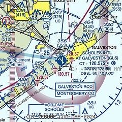
| Sectional chart |
|---|
|
CAUTION: Diagram may not be current

| Airport distance calculator |
|---|
|
|
| Sunrise and sunset |
|---|
|
Times for 06-Jun-2026
| | Local
(UTC-5) | | Zulu
(UTC) |
|---|
| Morning civil twilight | | 05:54 | | 10:54 |
| Sunrise | | 06:21 | | 11:21 |
| Sunset | | 20:16 | | 01:16 |
| Evening civil twilight | | 20:42 | | 01:42 |
|
| Current date and time |
|---|
| Zulu (UTC) | 07-Jun-2026 00:48:51 |
|---|
| Local (UTC-5) | 06-Jun-2026 19:48:51 |
|---|
|
| METAR |
|---|
| KGLS | 070037Z AUTO 15011KT 10SM SCT014 BKN019 BKN024 28/26 A2983 RMK AO2 T02830256
|
|
| TAF |
|---|
| KGLS | 062024Z 0620/0718 17011KT P6SM VCSH FEW010 SCT030 FM070100 17011KT P6SM SCT025 BKN050 FM070500 16015KT P6SM OVC050 FM071200 17015KT P6SM VCSH SCT020 BKN030
|
|
| NOTAMs |
|---|
NOTAMs are issued by the DoD/FAA and will open in a separate window not controlled by AirNav.
|
|


