FAA INFORMATION EFFECTIVE 19 FEBRUARY 2026
Location
| FAA Identifier: | GTB |
| Lat/Long: | 44-03-20.2000N 075-43-11.6200W
44-03.336667N 075-43.193667W
44.0556111,-75.7198944
(estimated) |
| Elevation: | 689.9 ft. / 210.3 m (surveyed) |
| Variation: | 13W (1990) |
| From city: | 1 mile NE of FORT DRUM, NY |
| Time zone: | UTC -5 (UTC -4 during Daylight Saving Time) |
| Zip code: | 13602 |
Airport Operations
| Airport use: | Private use. Permission required prior to landing |
| Control tower: | yes |
| ARTCC: | BOSTON CENTER |
| FSS: | BURLINGTON FLIGHT SERVICE STATION |
| NOTAMs facility: | GTB (NOTAM-D service available) |
| Attendance: | MON-FRI 0700-2200
OTR TIMES PPR. ARPT CLSD HOLS. |
| Pattern altitude: | R/W 1400 FT, F/W 2000 FT TURBO JET 2500 FT, OVERHEAD 3000 FT. |
| Segmented circle: | no |
| Lights: | SS-SR |
| Beacon: | white-white-green (lighted military airport)
LCTD ON 847'MSL TOWER WEST OF RWY 8. Operates sunset to sunrise. |
Airport Communications
| ATIS: | 119.525 |
| WHEELER-SACK GROUND: | 123.45 229.8 |
| WHEELER-SACK TOWER: | 118.75 290.25 49.8FM |
| WHEELER-SACK APPROACH: | 124.875 307.125 |
| WHEELER-SACK DEPARTURE: | 124.875 307.125 |
| CLEARANCE DELIVERY: | 123.65 |
| BASE OPS: | 126.2 233.7 |
| FLT FLW: | 141.025 319.25 |
| IC: | 307.125 |
| PMSV METRO: | 317.5 |
| WX ASOS at ART (13 nm W): | 132.325 (315-639-4002) |
- 344.6 PMSV AVBL THRU GRIFFISS AFB.
- ATCT-ARAC.
Nearby radio navigation aids
| VOR radial/distance | | VOR name | | Freq | | Var |
|---|
| ARTr079/16.1 | | WATERTOWN VORTAC | | 109.80 | | 12W |
Airport Services
Runway Information
Runway 3/21
| Dimensions: | 10000 x 150 ft. / 3048 x 46 m |
| Surface: | concrete, in good condition |
| Weight bearing capacity: | |
| Runway edge lights: | high intensity |
| RUNWAY 3 | | RUNWAY 21 |
| Latitude: | 44-02.728400N | | 44-04.310450N |
| Longitude: | 075-43.548150W | | 075-42.919583W |
| Elevation: | 679.3 ft. | | 660.5 ft. |
| Traffic pattern: | left | | right |
| Displaced threshold: | 1363 ft. | | no |
| Markings: | precision, in good condition | | precision, in good condition |
| Visual slope indicator: | 4-light PAPI on left (3.00 degrees glide path) | | 4-light PAPI on left (3.00 degrees glide path) |
| RVR equipment: | touchdown, rollout | | touchdown, rollout |
| Approach lights: | ALSF1: standard 2,400 foot high intensity approach lighting system with centerline sequenced flashers (category I) | | ALSF1: standard 2,400 foot high intensity approach lighting system with centerline sequenced flashers (category I) |
| Touchdown point: | yes, no lights | | yes, no lights |
| Instrument approach: | ILS/DME | | ILS/DME |
Runway 15/33
| Dimensions: | 5002 x 144 ft. / 1525 x 44 m |
| Surface: | concrete |
| Weight bearing capacity: | |
| Runway edge lights: | high intensity |
| RUNWAY 15 | | RUNWAY 33 |
| Latitude: | 44-03.708493N | | 44-03.138572N |
| Longitude: | 075-43.482278W | | 075-42.658322W |
| Elevation: | 665.9 ft. | | 689.9 ft. |
| Traffic pattern: | right | | left |
| Markings: | precision, in poor condition | | precision, in poor condition |
| RVR equipment: | touchdown, rollout | | touchdown, rollout |
| Approach lights: | MALSR: 1,400 foot medium intensity approach lighting system with runway alignment indicator lights | | |
| Touchdown point: | yes, no lights | | yes, no lights |
Runway 8/26
| Dimensions: | 4501 x 150 ft. / 1372 x 46 m |
| Surface: | asphalt/concrete
RWY 08/26 CNTR 75 FT CONC BTN RWY 03 AND TWY D, PCN 54, REMAINDER ASPH. |
| Weight bearing capacity: | |
| Runway edge lights: | low intensity |
| RUNWAY 8 | | RUNWAY 26 |
| Latitude: | 44-02.709683N | | 44-02.958150N |
| Longitude: | 075-43.725450W | | 075-42.757867W |
| Elevation: | 675.3 ft. | | 685.4 ft. |
| Traffic pattern: | right | | left |
| Markings: | basic, in poor condition | | basic, in poor condition |
| Touchdown point: | yes, no lights | | yes, no lights |
Airport Ownership and Management from official FAA records
| Ownership: | U.S. Army |
| Owner: | US ARMY AERONAUTICAL SVCS AGENCY
FORT BELVOIR, VA 22060 |
Additional Remarks
| - | SERVICE-L-AOE JASU-3(ASU600-270-DDP). FUEL-A++ (MIL); AVBL 1400-0300Z++MON-FRI, EXC HOL, OT PN. |
| - | MISC: WX SVC AVBL 24/7. DSN 772-6065, C315-772-6065. BACK-UP WX BRIEF AVBL FR 15 OWS SCOTT AFB DSN 576-9755/9702, C618-256-9755/9702. PRI WX SENSORS AUTOMATED H24. DRG AUGMENTATION/BACK-UP WX OBSERVATION PT IS OBST 033 DEGS-162 DEGS. PMSV FREQ NOT MONITORED SAT, SUN, AND FEDERAL HOL. |
| - | NS ABTMT - QUIET HRS 0300-1100Z++. |
| - | CUST/AG/IMG: 24 HR PN, CONSULT FCG. AERIAL PORT MSN ACFT PLAN ARR BTN 1300-0300Z++ MON-FRI EXC HOL, OT RQR ADVANCED COORD AND APVL. |
| - | RWY 03/21 ACLT STOP AND TKOF RUN DIST AVBL 10000 FT. |
| - | TFC PAT - R/W 1400 FT, F/W 2000 FT. TURBO JET 2500 FT. OVHD 3000 FT. |
| - | TWY G RSTD TO C130 OR SMALLER, MAX ACN 25. |
| - | SECTION OF RWY 08/26 BTN RWY 03/21 AND TWY D RATED CONC PCN 54 R/B/W/T. |
| - | TRAN ALERT: NO CATERING, CLEANING, LAV, TRASH REMOVAL, WATER, OR CREW TRNSP SVC AVBL. |
| - | BASE OPS OPR 1200-0400Z++ MON-FRI; CLSD SAT, SUN AND FEDERAL HOL. ALL TRAN ACFT INBD FOR PRK CTC BASE OPS 10 NM PRIOR TO LDG, MIL AIRCREWS MUST REGISTER WITH BASE OPS IF RON. TRAN R/W PRK SOUTH END OF NORTH RAMP. TWY G, N, P, R AND TWY L EAST OF TWY B DESIGNATED NONMOVEMENT AREA. ACFT INBD FOR AVN FLD MAINT ACT (AFMA) MUST ARR NO LATER THAN 1900Z++ CTC DSN 772-7536 C315-772-7536. EMERG CTC MT OPS CNTR DSN 772-8620 C315-772-8620. |
| - | FLUID - SP DE-ICE TYPE I AND IV AVBL WITH 3 HR PN. |
| - | RSTD: PPR CTC BASE OPS DSN 772-5681 C315-772-5681/5682. TENANT ACFT HAVE PRIORITY FOR LCL PAT OPS, TRAN MAY BE LTD. RWY 15-33.TWY G RSTD TO C130 OR SMALLER. SOD LDG/OPS RSTD TO CNTR, SOD. OASIS RST TO TENANT R/W HOT REFUL OPS, LDG/DEP PROHIBITED WHEN CLSD. TWY B BTN TWY A AND N RAMP CLSD. |
| - | CTN: UAS OPR WI 20NM KGTB SFC-FL290. EXTSY MIL ACFT ACTIVITY VCNTY ARPT MIL ACFT REFER TO FLIP AP/1 PRIOR TO OPS ON FORT DRUM OR WI R-5201. NARROW TWY A,B INT ARC 40 FT WIDE. N RAMP EDGE LGT US. TWY B EDGE LGT US BTN TWY A AND SABRE HELIPAD. W RAMP UNLGTD. RSC NOT MNTN WHEN BASE OPS IS CLSD. WILDLIFE HAZ, REFER TO AP/1. |
Instrument Procedures
NOTE: All procedures below are presented as PDF files. If you need a reader for these files, you should download the free Adobe Reader.NOT FOR NAVIGATION. Please procure official charts for flight.
FAA instrument procedures published for use from 19 February 2026 at 0901Z to 19 March 2026 at 0900Z.
IAPs - Instrument Approach Procedures |
|---|
| HI-ILS OR LOC RWY 03 | |
download (176KB) |
| HI-ILS OR LOC RWY 21 | |
download (253KB) |
| ILS OR LOC RWY 03 | |
download (174KB) |
| ILS OR LOC RWY 21 | |
download (175KB) |
| RNAV (GPS) RWY 03 | |
download (100KB) |
| RNAV (GPS) RWY 15 | |
download (81KB) |
| RNAV (GPS) RWY 21 | |
download (97KB) |
| RNAV (GPS) RWY 33 | |
download (87KB) |
| Radar Approach Procedures available | |
download (130KB) |
Departure Procedures |
|---|
| WATERTOWN TWO | |
download (91KB) |
| NOTE: Special Take-Off Minimums/Departure Procedures apply | |
download (454KB) |
Other nearby airports with instrument procedures:
KART - Watertown International Airport (13 nm W)
KOGS - Ogdensburg International Airport (39 nm N)
KPTD - Potsdam Municipal Airport/Damon Field (50 nm NE)
KRME - Griffiss International Airport (51 nm S)
KFZY - Oswego County Airport (51 nm SW)
|
|

Road maps at:
MapQuest
Bing
Google
| Aerial photo |
|---|
WARNING: Photo may not be current or correct

Do you have a better or more recent aerial photo of Wheeler-Sack Army Airfield that you would like to share? If so, please send us your photo.
|
| Sectional chart |
|---|
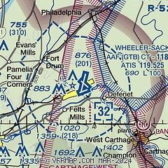
|
 Download PDF
of official airport diagram from the FAA
| Airport distance calculator |
|---|
|
|
| Sunrise and sunset |
|---|
|
Times for 19-Feb-2026
| | Local
(UTC-5) | | Zulu
(UTC) |
|---|
| Morning civil twilight | | 06:28 | | 11:28 |
| Sunrise | | 06:57 | | 11:57 |
| Sunset | | 17:36 | | 22:36 |
| Evening civil twilight | | 18:06 | | 23:06 |
|
| Current date and time |
|---|
| Zulu (UTC) | 19-Feb-2026 23:33:03 |
|---|
| Local (UTC-5) | 19-Feb-2026 18:33:03 |
|---|
|
| METAR |
|---|
| KGTB | 192255Z AUTO 14004KT 10SM OVC022 04/M02 A2994 RMK AO2 SLP145 T00361022
|
KART
14nm W | 192256Z AUTO 00000KT 10SM OVC027 03/M05 A2997 RMK AO2 SLP152 T00281050
|
|
| TAF |
|---|
| KGTB | 191700Z 1917/2023 17012KT 9999 FEW020 QNH2995INS BECMG 1918/1919 15010KT 9999 SCT025 OVC030 620303 QNH2980INS BECMG 2014/2015 12010G15KT 4800 -RASN OVC008 620159 QNH2953INS TX04/1917Z TN00/2001Z
|
KART
14nm W | 191729Z 1918/2018 03006KT P6SM SCT025 FM192000 00000KT P6SM BKN025 FM200600 07006KT P6SM SCT025 FM200700 08004KT P6SM BKN025 PROB30 2013/2015 4SM -FZRA OVC025 FM201600 08007KT 2SM -SHRA BR BKN012
|
|
| NOTAMs |
|---|
NOTAMs are issued by the DoD/FAA and will open in a separate window not controlled by AirNav.
|
|


