FAA INFORMATION EFFECTIVE 14 MAY 2026
Location
| FAA Identifier: | GUC |
| Lat/Long: | 38-32-03.6000N 106-55-54.3000W
38-32.060000N 106-55.905000W
38.5343333,-106.9317500
(estimated) |
| Elevation: | 7679.6 ft. / 2340.7 m (surveyed) |
| Variation: | 12E (1990) |
| From city: | 1 mile SW of GUNNISON, CO |
| Time zone: | UTC -6 (UTC -7 during Standard Time) |
| Zip code: | 81230 |
Airport Operations
| Airport use: | Open to the public |
| Activation date: | 08/1947 |
| Control tower: | no |
| ARTCC: | DENVER CENTER |
| FSS: | DENVER FLIGHT SERVICE STATION |
| NOTAMs facility: | GUC (NOTAM-D service available) |
| Attendance: | 0600-2100
ARPT CONDS UNMON AT NGT FM LAST ACR ARR/DEP TIL 0530 LCL. SEE NOTAMS FOR MOST UP-TO-DATE CONDS. |
| Wind indicator: | lighted |
| Segmented circle: | yes |
| Lights: | ACTVT MALSF RWY 06; PAPI RWY 06 & 24 - CTAF. REIL RWY 24; HIRL RWY 06/24 OPER 0600-2230. |
| Beacon: | white-green (lighted land airport)
ROTG BCN OPERS SS-2230 & 0600-SR. |
| Fire and rescue: | ARFF index B |
| Airline operations: | CLSD TO UNSKED ACR OPS WITH MORE THAN 30 PAX SEATS EXCP PPR. CALL AMGR 970-641-2304. |
Airport Communications
| CTAF/UNICOM: | 122.7 |
| WX AWOS-3PT: | 135.075 (970-641-3240) |
- APCH/DEP CTL SVC PRVDD BY DENVER ARTCC (ZDV) ON FREQ 124.5/350.25 (GUNNISON RCAG RCAG).
Nearby radio navigation aids
| VOR radial/distance | | VOR name | | Freq | | Var |
|---|
| HBUr032/7.1 | | BLUE MESA VOR/DME | | 114.90 | | 14E |
Airport Services
| Fuel available: | 100LL JET-A+ |
| Parking: | hangars and tiedowns |
| Airframe service: | NONE |
| Powerplant service: | NONE |
| Bottled oxygen: | NONE |
| Bulk oxygen: | HIGH/LOW |
Runway Information
Runway 6/24
| Dimensions: | 9400 x 150 ft. / 2865 x 46 m |
| Surface: | asphalt/grooved, in excellent condition |
| Weight bearing capacity: | | Single wheel: | 75.0 | | Double wheel: | 160.0 | | Double tandem: | 250.0 |
|
| Runway edge lights: | high intensity |
| RUNWAY 6 | | RUNWAY 24 |
| Latitude: | 38-31.946395N | | 38-32.384462N |
| Longitude: | 106-56.705175W | | 106-54.814778W |
| Elevation: | 7658.0 ft. | | 7679.5 ft. |
| Traffic pattern: | right | | left |
| Runway heading: | 062 magnetic, 074 true | | 242 magnetic, 254 true |
| Declared distances: | TORA:9400 TODA:9400 ASDA:9400 LDA:9400 | | TORA:9400 TODA:9400 ASDA:9400 LDA:9400 |
| Markings: | precision, in good condition | | nonprecision, in good condition |
| Visual slope indicator: | 4-light PAPI on left (3.20 degrees glide path) | | 4-light PAPI on left (3.60 degrees glide path)
PAPI UNUSBL BYD 2.5 NM; DOES NOT PRVD OBST CLNC BYD 2.5 NM FROM THR. |
| Approach lights: | MALSF: 1,400 foot medium intensity approach lighting system with sequenced flashers | | |
| Runway end identifier lights: | | | yes |
| Touchdown point: | yes, no lights | | yes, no lights |
| Instrument approach: | ILS/DME | | |
Runway 17/35
| Dimensions: | 2981 x 150 ft. / 909 x 46 m |
| Surface: | turf/gravel, in fair condition |
| RUNWAY 17 | | RUNWAY 35 |
| Latitude: | 38-31.969608N | | 38-31.478655N |
| Longitude: | 106-56.363600W | | 106-56.363860W |
| Elevation: | 7660.9 ft. | | 7647.3 ft. |
| Traffic pattern: | right | | left |
| Runway heading: | 168 magnetic, 180 true | | 348 magnetic, 000 true |
| Displaced threshold: | no | | 233 ft. |
| Declared distances: | TORA:2981 TODA:2981 ASDA:2981 LDA:2981 | | TORA:2981 TODA:2981 ASDA:2981 LDA:2748 |
| Markings: | none, in fair condition | | none, in fair condition |
| Touchdown point: | yes, no lights | | yes, no lights |
Airport Ownership and Management from official FAA records
| Ownership: | Publicly-owned |
| Owner: | COUNTY OF GUNNISON
519 RIO GRANDE
GUNNISON, CO 81230
Phone 970-641-2304 |
| Manager: | RICHARD LAMPORT
519 RIO GRANDE
GUNNISON, CO 81230
Phone (970) 642-7388 |
Additional Remarks
| A39-06/24 | PCR VALUE: 410/F/B/X/T |
| - | HIGH TRRN ALL QUADS. |
| - | RWY 17/35 CLSD 1 DEC - 1 MAY. |
| - | COLD TEMPERATURE AIRPORT. ALTITUDE CORRECTION REQUIRED AT OR BELOW -25C. |
| - | MIGRATORY BIRD ACT 1 JAN -THRU- 1 JUN. |
Instrument Procedures
NOTE: All procedures below are presented as PDF files. If you need a reader for these files, you should download the free Adobe Reader.NOT FOR NAVIGATION. Please procure official charts for flight.
FAA instrument procedures published for use from 14 May 2026 at 0901Z to 11 June 2026 at 0900Z.
IAPs - Instrument Approach Procedures |
|---|
| ILS OR LOC RWY 06 | |
download (447KB) |
| RNAV (RNP) RWY 06 | |
download (450KB) |
| RNAV (RNP) RWY 24 | |
download (426KB) |
| GPS-B | |
download (435KB) |
| VOR OR GPS-A | |
download (385KB) |
| NOTE: Special Alternate Minimums apply | |
download (145KB) |
| NOTE: Special Take-Off Minimums/Departure Procedures apply | |
download (145KB) |
Other nearby airports with instrument procedures:
KASE - Aspen-Pitkin County Airport/Sardy Field (41 nm N)
KANK - Salida Airport/Harriett Alexander Field (41 nm E)
KAEJ - Central Colorado Regional Airport (42 nm NE)
KMTJ - Montrose Regional Airport (45 nm W)
KLXV - Lake County Airport (50 nm NE)
|
|

Road maps at:
MapQuest
Bing
Google
| Aerial photo |
|---|
WARNING: Photo may not be current or correct

Do you have a better or more recent aerial photo of Gunnison-Crested Butte Regional Airport that you would like to share? If so, please send us your photo.
|
| Sectional chart |
|---|
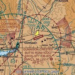
|
| Airport distance calculator |
|---|
|
|
| Sunrise and sunset |
|---|
|
Times for 23-May-2026
| | Local
(UTC-6) | | Zulu
(UTC) |
|---|
| Morning civil twilight | | 05:20 | | 11:20 |
| Sunrise | | 05:51 | | 11:51 |
| Sunset | | 20:18 | | 02:18 |
| Evening civil twilight | | 20:49 | | 02:49 |
|
| Current date and time |
|---|
| Zulu (UTC) | 23-May-2026 12:26:07 |
|---|
| Local (UTC-6) | 23-May-2026 06:26:07 |
|---|
|
| METAR |
|---|
| KGUC | 231156Z AUTO 33006KT 10SM CLR M02/M03 A3021 RMK AO2 SLP198 T10171033 10072 21017 52013 FZRANO $
|
|
| TAF |
|---|
| KGUC | 231133Z 2312/2412 VRB03KT P6SM FEW250 FM231700 27013G23KT P6SM FEW100 FEW250 FM240000 30010KT P6SM FEW100 FEW250 FM240300 VRB04KT P6SM FEW100 FEW250
|
|
| NOTAMs |
|---|
NOTAMs are issued by the DoD/FAA and will open in a separate window not controlled by AirNav.
|
|


