FAA INFORMATION EFFECTIVE 19 MARCH 2026
Location
| FAA Identifier: | HSA |
| Lat/Long: | 30-22-04.0970N 089-27-16.6050W
30-22.068283N 089-27.276750W
30.3678047,-89.4546125
(estimated) |
| Elevation: | 22.8 ft. / 6.9 m (surveyed) |
| Variation: | 02W (2020) |
| From city: | 8 miles NW of BAY ST LOUIS, MS |
| Time zone: | UTC -5 (UTC -6 during Standard Time) |
| Zip code: | 39556 |
Airport Operations
| Airport use: | Open to the public |
| Activation date: | 05/1970 |
| Control tower: | yes |
| ARTCC: | HOUSTON CENTER |
| FSS: | GREENWOOD FLIGHT SERVICE STATION |
| NOTAMs facility: | HSA (NOTAM-D service available) |
| Attendance: | MON-FRI 0700-1900, ALL SAT-SUN 0800-2000 |
| Wind indicator: | lighted |
| Segmented circle: | yes |
| Lights: | ACTVT MALSR RWY 18; REIL RWY 36; PAPI RWY 18 & 36; HIRL RWY 18/36 - CTAF. |
| Beacon: | white-green (lighted land airport)
Operates sunset to sunrise. |
| Fire and rescue: | ARFF index A |
| Airline operations: | ACR ACFT OF AT LEAST 31 PAX SEATS OR MORE OR CARGO OPS RQRG INCRD ARFF INDEX, 48 HRS PPR 228-342-5415. |
| International operations: | customs landing rights airport |
Airport Communications
| CTAF: | 127.15 |
| UNICOM: | 122.95 |
| WX AWOS-3PT: | 118.375 (228-466-9320) |
| STENNIS GROUND: | 121.725 229.4 [0700-2100] |
| STENNIS TOWER: | 127.15 229.4 [0700-2100] |
| GULFPORT APPROACH: | 124.6 ;130-309 127.5 ;310-129 |
| GULFPORT DEPARTURE: | 124.6 ;130-309 127.5 ;310-129 |
| WX AWOS-3PT at MJD (12 nm NW): | 119.075 (601-798-4136) |
| WX ASOS at ASD (19 nm W): | 132.475 (985-259-6242) |
- APCH/DEP SVC PRVDD BY HOUSTON ARTCC (ZHU) ON FREQS 127.65/285.475 (MOBILE RCAG) WHEN GULFPORT APCH CLSD.
Nearby radio navigation aids
| VOR radial/distance | | VOR name | | Freq | | Var |
|---|
| PCUr124/18.4 | | PICAYUNE VOR/DME | | 113.95 | | 05E |
| GPTr261/19.7 | | GULFPORT VORTAC | | 109.00 | | 02E |
| NDB name | | Hdg/Dist | | Freq | | Var | | ID |
|---|
| HANCO | | 181/5.0 | | 221 | | 02W | | HS | .... ... |
| BOGALUSA | | 146/37.3 | | 353 | | 00W | | GVB | --. ...- -... |
Airport Services
| Fuel available: | 100LL JET-A+
100LL:FOR FUEL & FBO SVCS AFT HRS CALL 228-463-2389. |
| Parking: | hangars and tiedowns |
| Airframe service: | MAJOR
FOR ALL RPRS CALL 228-463-2389. |
| Powerplant service: | MAJOR |
Runway Information
Runway 18/36
| Dimensions: | 8498 x 150 ft. / 2590 x 46 m |
| Surface: | asphalt/grooved, in good condition |
| Weight bearing capacity: | | Double tandem: | 472.0 | | Dual double tandem: | 955.0 |
|
| Runway edge lights: | high intensity |
| RUNWAY 18 | | RUNWAY 36 |
| Latitude: | 30-22.769195N | | 30-21.367378N |
| Longitude: | 089-27.274515W | | 089-27.278977W |
| Elevation: | 22.5 ft. | | 12.7 ft. |
| Traffic pattern: | left | | left |
| Runway heading: | 182 magnetic, 180 true | | 002 magnetic, 000 true |
| Declared distances: | TORA:8498 TODA:8498 ASDA:8498 LDA:8498 | | TORA:8498 TODA:8498 ASDA:8498 LDA:8498 |
| Markings: | precision, in good condition | | nonprecision, in good condition |
| Visual slope indicator: | 4-light PAPI on left (3.00 degrees glide path) | | 4-light PAPI on left (3.00 degrees glide path) |
| Approach lights: | MALSR: 1,400 foot medium intensity approach lighting system with runway alignment indicator lights | | |
| Runway end identifier lights: | no | | yes |
| Touchdown point: | yes, no lights | | yes, no lights |
| Instrument approach: | ILS | | |
| Obstructions: | 40 ft. tree, 2100 ft. from runway, 200 ft. left of centerline, 47:1 slope to clear | | 55 ft. trees, 2100 ft. from runway, 34:1 slope to clear |
Airport Ownership and Management from official FAA records
| Ownership: | Publicly-owned |
| Owner: | HANCOCK CO PORT & HARBOR CMSN
14054 FRED & AL KEY RD
KILN, MS 39556
Phone 228-467-7070 |
| Manager: | AUSTIN JENKINS, C.M., ACE
7250 STENNIS AIRPORT RD
KILN, MS 39556
Phone 228-467-7070 |
Additional Remarks
| A39-18/36 | PCR VALUE: 411/F/B/X/T |
| - | WHEN ATCT CLSD, FOR CD CTC HOUSTON ARTCC AT 281-230-5622. |
| - | AVOID FLYING OVR SCHOOLS .4 NM E OF RWY 18/36 WHEN POSS. |
| - | FBO ATNDD MON-FRI 0700-2000, SAT-SUN 0800-1800. |
| - | AFT HRS CALLOUT - 228-463-2389. |
| - | NMRS LOW FLYING FISH SPOTTER ACFT OPS NEAR SHORELINE BTN GULFPORT & BAY ST. LOUIS. |
| - | BIRDS ON & INVOF ARPT. |
Instrument Procedures
NOTE: All procedures below are presented as PDF files. If you need a reader for these files, you should download the free Adobe Reader.NOT FOR NAVIGATION. Please procure official charts for flight.
FAA instrument procedures published for use from 19 March 2026 at 0901Z to 16 April 2026 at 0900Z.
IAPs - Instrument Approach Procedures |
|---|
| ILS Y OR LOC Y RWY 18 **CHANGED** | |
download (421KB) |
| ILS Z OR LOC Z RWY 18 **CHANGED** | |
download (417KB) |
| RNAV (GPS) RWY 18 **CHANGED** | |
download (335KB) |
| RNAV (GPS) RWY 36 **CHANGED** | |
download (341KB) |
| NDB RWY 18 **CHANGED** | |
download (315KB) |
| NOTE: Special Alternate Minimums apply | |
download (163KB) |
Other nearby airports with instrument procedures:
KMJD - Picayune Municipal Airport (12 nm NW)
KASD - Slidell Airport (19 nm W)
KGPT - Gulfport-Biloxi International Airport (20 nm E)
M13 - Poplarville/Pearl River County Airport (25 nm N)
KBIX - Keesler Air Force Base (28 nm E)
|
|

Road maps at:
MapQuest
Bing
Google
| Aerial photo |
|---|
WARNING: Photo may not be current or correct

Do you have a better or more recent aerial photo of Stennis International Airport that you would like to share? If so, please send us your photo.
|
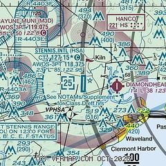
| Sectional chart |
|---|
|
CAUTION: Diagram may not be current

| Airport distance calculator |
|---|
|
|
| Sunrise and sunset |
|---|
|
Times for 14-Apr-2026
| | Local
(UTC-5) | | Zulu
(UTC) |
|---|
| Morning civil twilight | | 06:08 | | 11:08 |
| Sunrise | | 06:33 | | 11:33 |
| Sunset | | 19:24 | | 00:24 |
| Evening civil twilight | | 19:48 | | 00:48 |
|
| Current date and time |
|---|
| Zulu (UTC) | 14-Apr-2026 09:41:00 |
|---|
| Local (UTC-5) | 14-Apr-2026 04:41:00 |
|---|
|
| METAR |
|---|
| KHSA | 140150Z 00000KT 10SM CLR 22/18 A3019
|
KMJD
12nm NW | 140915Z AUTO 00000KT 3SM BR CLR 15/15 A3013 RMK AO2
|
KASD
18nm SW | 140918Z AUTO 00000KT 10SM BKN020 16/14 A3013 RMK AO2 T01560144
|
KGPT
19nm E | 140853Z AUTO 16008KT 10SM CLR 21/16 A3014 RMK AO2 SLP205 T02110161 56019
|
|
| TAF |
|---|
KASD
18nm SW | 140520Z 1406/1506 00000KT P6SM SKC FM141500 16005KT P6SM FEW070 FEW250
|
KGPT
19nm E | 140520Z 1406/1506 15009KT P6SM SCT016
|
|
| NOTAMs |
|---|
NOTAMs are issued by the DoD/FAA and will open in a separate window not controlled by AirNav.
|
|


