FAA INFORMATION EFFECTIVE 14 MAY 2026
Location
| FAA Identifier: | MJD |
| Lat/Long: | 30-29-14.9000N 089-39-04.3000W
30-29.248333N 089-39.071667W
30.4874722,-89.6511944
(estimated) |
| Elevation: | 55.3 ft. / 16.9 m (surveyed) |
| Variation: | 01E (2000) |
| From city: | 2 miles SE of PICAYUNE, MS |
| Time zone: | UTC -5 (UTC -6 during Standard Time) |
| Zip code: | 39466 |
Airport Operations
| Airport use: | Open to the public |
| Activation date: | 11/1999 |
| Control tower: | no |
| ARTCC: | HOUSTON CENTER |
| FSS: | GREENWOOD FLIGHT SERVICE STATION |
| NOTAMs facility: | GWO (NOTAM-D service available) |
| Attendance: | 0800-1700 |
| Wind indicator: | lighted |
| Segmented circle: | yes |
| Lights: | ACTVT PAPI RWY 18 & 36; MIRL RWY 18/36 - CTAF. |
| Beacon: | white-green (lighted land airport)
Operates sunset to sunrise. |
Airport Communications
| CTAF/UNICOM: | 122.8 |
| WX AWOS-3PT: | 119.075 (601-798-4136) |
| GULFPORT APPROACH: | 124.6 |
| GULFPORT DEPARTURE: | 124.6 |
| WX ASOS at ASD (12 nm SW): | 132.475 (985-259-6242) |
| WX AWOS-3PT at HSA (12 nm SE): | 118.375 (228-466-9320) |
- APCH/DEP SVC PRVDD BY HOUSTON ARTCC (ZHU) ON FREQS 127.65/285.475 (MOBILE RCAG) WHEN GULFPORT APCH CTL (GPT) CLSD.
Nearby radio navigation aids
| VOR radial/distance | | VOR name | | Freq | | Var |
|---|
| PCUr132/6.0 | | PICAYUNE VOR/DME | | 113.95 | | 05E |
| GPTr277/30.1 | | GULFPORT VORTAC | | 109.00 | | 02E |
| NDB name | | Hdg/Dist | | Freq | | Var | | ID |
|---|
| HANCO | | 284/10.3 | | 221 | | 02W | | HS | .... ... |
| BOGALUSA | | 155/26.0 | | 353 | | 00W | | GVB | --. ...- -... |
Airport Services
| Fuel available: | 100LL JET-A
A:CCTV AT TERMINAL AND FUEL PUMPS.
100LL:FUEL AVBL 24 HRS WITH CREDIT CARD. |
| Parking: | hangars and tiedowns |
| Airframe service: | MAJOR |
| Powerplant service: | MAJOR |
Runway Information
Runway 18/36
| Dimensions: | 5000 x 75 ft. / 1524 x 23 m |
| Surface: | asphalt, in good condition |
| Weight bearing capacity: | |
| Runway edge lights: | medium intensity |
| RUNWAY 18 | | RUNWAY 36 |
| Latitude: | 30-29.661407N | | 30-28.836837N |
| Longitude: | 089-39.071017W | | 089-39.072255W |
| Elevation: | 55.1 ft. | | 48.9 ft. |
| Traffic pattern: | left | | left |
| Runway heading: | 179 magnetic, 180 true | | 359 magnetic, 000 true |
| Markings: | nonprecision, in fair condition | | nonprecision, in fair condition |
| Visual slope indicator: | 2-light PAPI on left (3.00 degrees glide path) | | 2-light PAPI on left (3.00 degrees glide path) |
| Touchdown point: | yes, no lights | | yes, no lights |
| Obstructions: | 56 ft. trees, 1715 ft. from runway, 27:1 slope to clear | | 29 ft. tree, 1200 ft. from runway, 300 ft. left of centerline, 34:1 slope to clear |
Airport Ownership and Management from official FAA records
| Ownership: | Publicly-owned |
| Owner: | CITY OF PICAYUNE
203 GOODYEAR BLVD
PICAYUNE, MS 39466
Phone 601-798-9770 |
| Manager: | WAYNE WILSON
148 RUNWAY RD
PICAYUNE, MS 39466
Phone 601-590-0260
ARPT HAS 24 HR LGTD & SCTY CAMERAS AT FUEL-FARM & TRML BLDG. 24 HR ACES FOR PILOTS & PAX AT TRML BLDG. ALTN FONE 601-749-7017. |
Additional Remarks
| - | BIRDS & GEESE INVOF ARPT. |
| - | CK NOTAMS FOR OCNL RSTRD ASP USE BY STENNIS SPACE CNTR. |
| - | FOR CD CTC GULFPORT APCH AT 228-265-6151, WHEN APCH CLSD CTC HOUSTON ARTCC AT 281-230-5622. |
| - | COURTESY VEHICLE AVBL. |
| - | (CONTACT TITLE) JIM LUKE, CITY MAYOR. |
Instrument Procedures
NOTE: All procedures below are presented as PDF files. If you need a reader for these files, you should download the free Adobe Reader.NOT FOR NAVIGATION. Please procure official charts for flight.
FAA instrument procedures published for use from 14 May 2026 at 0901Z to 11 June 2026 at 0900Z.
IAPs - Instrument Approach Procedures |
|---|
| RNAV (GPS) RWY 36 | |
download (294KB) |
| RNAV (GPS) Y RWY 18 | |
download (253KB) |
| RNAV (GPS) Z RWY 18 | |
download (257KB) |
| VOR-A | |
download (174KB) |
| NOTE: Special Alternate Minimums apply | |
download (37KB) |
| NOTE: Special Take-Off Minimums/Departure Procedures apply | |
download (116KB) |
Other nearby airports with instrument procedures:
KASD - Slidell Airport (12 nm SW)
KHSA - Stennis International Airport (12 nm SE)
M13 - Poplarville/Pearl River County Airport (19 nm NE)
KBXA - George R Carr Memorial Air Field (22 nm NW)
KGPT - Gulfport-Biloxi International Airport (30 nm E)
|
|

Road maps at:
MapQuest
Bing
Google
| Aerial photo |
|---|
WARNING: Photo may not be current or correct

Do you have a better or more recent aerial photo of Picayune Municipal Airport that you would like to share? If so, please send us your photo.
|
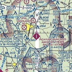
| Sectional chart |
|---|
|
| Airport distance calculator |
|---|
|
|
| Sunrise and sunset |
|---|
|
Times for 30-May-2026
| | Local
(UTC-5) | | Zulu
(UTC) |
|---|
| Morning civil twilight | | 05:31 | | 10:31 |
| Sunrise | | 05:58 | | 10:58 |
| Sunset | | 19:54 | | 00:54 |
| Evening civil twilight | | 20:21 | | 01:21 |
|
| Current date and time |
|---|
| Zulu (UTC) | 30-May-2026 06:18:06 |
|---|
| Local (UTC-5) | 30-May-2026 01:18:06 |
|---|
|
| METAR |
|---|
KHSA
13nm SE | 300050Z 18010KT 10SM FEW018 26/23 A2988
|
KASD
15nm SW | 300553Z AUTO 00000KT 10SM CLR 22/22 A2990 RMK AO2 SLP126 T02220217 10272 20222 403110206 50003 $
|
|
| TAF |
|---|
KASD
15nm SW | 300520Z 3006/3106 00000KT P6SM FEW035 SCT250
|
|
| NOTAMs |
|---|
NOTAMs are issued by the DoD/FAA and will open in a separate window not controlled by AirNav.
|
|

